II. Materials and Methods
2.1 Study area
This study was carried out in the southern part of Zimbabwe
(Fig. 2.2) in the Mzingwane catchment, within the Limpopo basin. The Limpopo
basin (Fig.2.1) covers up to 1.3 % of the African continent. The Mzingwane
catchment is one of the seven catchment areas that have been demarcated by the
new water legislation of 1998. The six other catchments are Gwayi, Sanyati,
Manyame, Mazoe, Save and Runde. The Mzingwane catchment is located in a semi
arid region that is characterized by highly variable rainfall concentrated in
one rainy season, separated by relatively long dry seasons (Lawrence and
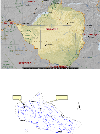
Hasnip, 2004). The Mzingwane catchment is divided into four sub catchments,
which are Upper Mzingwane, Lower Mzingwane, Mwenezi and Shashe (Fig. 2.3). The
annual rainfall in the Mzingwane catchment ranges from 300mm in the south to
635mm in the north (Table 2.1). Temporal distribution of rainfall follows the
general pattern of southern African region. The coldest month (July) when
minimum temperature goes below 0oC as well as the hottest month
(October) are both comprised in the dry months that go from April to October.
The hottest areas are found around Beitbridge (Conley, 1996 in Mwenge, 2004).
The Mzingwane catchment has three major rivers: the Shashe, Umzingwane and
Mwenezi. These rivers flow in the southeastern direction into the Limpopo River
carrying and depositing sediments along their courses. There is almost no flow
in the dry season and riverbeds are sandy alluvial of considerable thickness
providing big storage of water3. One of the major features of
aridity of the catchment is that the mean annual potential evapotranspiration
rates are higher than the mean annual rainfall (1800mm as compared to 465mm).
This status indicates low runoff generation and aquifer recharge (Mwenge,
2004).
3 Waternet CN133, 2003 in Mwenge, 2004
Table 2.1. Limpopo basin: areas and rainfall by country
Country
Total area of
the country
(km2)
Area of the
country within
the basin
(km2)
As % of
total area of
basin (%)
As % of total
area of
country (%)
Average annual
rainfall in the
basin
area
(mm)
|
|
|
|
|
min. max. mean
|
|
Botswana
|
581730
|
80118
|
19.9
|
13.8
|
290 555
|
425
|
|
Zimbabwe
|
390760
|
51467
|
12.38
|
13.2
|
300 635
|
465
|
|
South Africa
|
11221040
|
185298
|
4631
|
65.2
|
290 1040
|
590
|
|
Mozambique
|
801590
|
84981
|
21.1
|
10.6
|
355 865
|
535
|
|
For Limpopo
|
|
401864
|
100.0
|
|
290 1040
|
530
|
(From FAO, 1997)
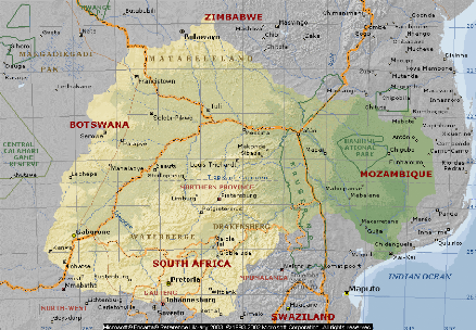
Fig. 2.1. Map of the Limpopo basin (from Encarta library 2003)
Nature Park (Matopos)
UPPER MZINGWANE
Communal lands (Insiza district)
N
MWENEZI
SHASHE
LOWER MZINGWANE
Rivers.shp
Boundary.shp
Fig 2. 2. Map of Zimbabwe (from Encarta Library 2003)
0 100 Kilometers
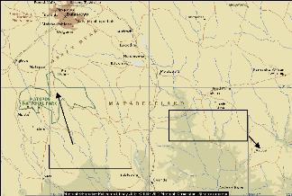
Fig. 2. 3. Map of the Mzingwane Catchment (Limpopo basin in
Zimbabwe)
The Limpopo River in southeastern Africa, rising as the
Krokodil River in the mountainous Witwatersrand region of northern South
Africa, is a trans-boundary river shared by Botswana, South Africa, Mozambique
and Zimbabwe. The Krokodil River then becomes the Limpopo and continues
northeast along the border between Botswana and South Africa, then east along
the border between Zimbabwe and South Africa. It flows southeast through
southern Mozambique before entering the Indian Ocean near Xai-Xai. The Limpopo
river is one of the most anthropogenically impacted Rivers in the Southern
African region and has vast tracks of its length covered by sand and silt and
seasonal flow only during the rainy season which spans from November to
April.
Site description
The eight selected small reservoirs are located in the
Mzingwane catchment, with four in the Matobo (Matopos) National Park and four
in the Insiza district around Avoca Business centre (Fig.2.4). The National
Park is located 34 km south of Bulawayo, at 28o Longitude East and
20o Latitude South. It represents one of the major tourist
attractions in Zimbabwe. It contains majestic granite scenery; the landscape
has been carved out from an almost flat surface of granite by millions of years
of weathering, resulting in great «whalebacks» and domes, and
castle-like formations (Tregold, 1996). The vegetation in the park is quite
different from that of the surrounding countryside, and supports many species
of animals and prolific bird life. The park is comprised of a game reserve and
a recreational park, both of which contain a number of small reservoirs. The
recreational park (western part) is separated from the game reserve (eastern
part) by the main road Bulawayo-Kezi. Mpopoma and Chitampa reservoirs, in the
game reserve, are respectively located at 7 and 2 km from the entrance gate. In
the recreational park, Mezilume reservoir is located at approximately 5 km from
the game park entrance gate while Maleme is at 7 km. Mezilume and Maleme are
located in the so-called Central Wild Area while Chitampa and Mpopoma are
located in the Whovi Wild Area (Game Park). Fish are abundant in most of these
reservoirs. Avoca Business Centre (in Insiza district) is located at 127 km
east of Bulawayo and its geographic coordinates are 20o 47' latitude
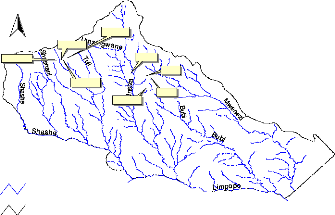
south and 29o 31'longitude east. Fig 2.3 and 2.4 show the location
of selected small reservoirs.
Dams in Matopos NP
Dams in communal lands
Fig 2.4. Location of the study sites
Bo un d ary.s h p
N
Maleme
Chitampa
Mpopoma
~~~~ Sibasa
~
~~
Dewa
Mezilume
~
Denje
Makoshe
Rivers.shp
~ Gps coordinatesfrk.dbf
Fig.2.5 Location of reservoirs in the Mzingwane catchment
A summary of the studied reservoirs located in communal lands
is presented in Table 2.2. The main users of the reservoir are farmers located
mainly downstream of the dam. Sibasa is an old perennial reservoir known to
have survived the drought period being recharged by groundwater.
Table 2.2. Some characteristics of small reservoir the studied
reservoirs in the communal lands, Insiza district, Zimbabwe.
|
Characteristics
|
|
Reservoirs
|
|
|
Makoshe
|
Sibasa
|
Denje
|
Dewa
|
|
Location
Capacity (m3)
Type
Construction period
Nature
|
Ward 6 926,000 Earthy 1997-98
-
|
Ward 11 -
Earthy
1945-50
Perennial
|
Ward 7
- Earthy
-
Not perennial
|
Ward 7
- Earthy
-
Not perennial
|
2.1.1 Land and water use in the communal Lands
Makoshe reservoir is located in a relatively flat area and its
water occupies a large surface. Many standing trees are still present in the
reservoir showing that the area was vegetated before the construction of the
reservoir. The substrate is mainly composed of dark grayish sand (Table 3.2)
(expansive and slippery since mixed with clay) and the littoral land fairly
covered by vegetation. The area may be subject to erosion in time of heavy
rainfalls. Big rocks are located mainly along the dam wall and some are
scattered in the reservoir. Water from the reservoir is allocated to the
following uses: irrigation, domestic, livestock, fishing, garden and drip
irrigation. Drip irrigation is pumping water for 18 ha plot for some
beneficiaries involved in the construction of the reservoir. Approximately 200
households that belong to two villages, Bambanani-Makoshe and Mbawulo, utilize
Makoshe reservoir's water. There are no farms upstream of the reservoir, all
the gardens and farms being located downstream of the reservoir. A number of
birds were observed belonging to the genus Phalacrocorax,
Ceryle, Ceyx, Hirundo and Nectarinia.
The shoreline vegetation of Sibasa reservoir is dominated by
Cyperus spp and the Water Clover Marsilea vestita. The water
is having a whitish (milky) colour. The reservoir is located at 200 m to the
first homestead of Sibasa village that is slightly elevated compared to the
reservoir. The reservoir is mainly allocated to livestock use, though it is
used as well for domestic purposes and recreation (fishing). No farm is located
in the close vicinity of the reservoir. A white granite hill is located
upstream of the reservoir. Some trees are found in the surroundings of the
reservoir as well as some rocks, which are also part of the substrates in the
reservoir. The area has suffered from a shortage of rainfall the whole period
except January where 211 mm of rain where recorded (Table 2.3). Few birds
belonging to Phalacrocorax sp., and Ceryle rudis
were observed actively fishing in the reservoir.
Table 2.3. Rainfall pattern in Filabusi district and Sibasa
village area during 2004/2005 (Insiza District)
|
Area
|
Oct
|
Nov
|
Dec
|
Jan
|
Feb
|
March
|
April
|
Total
|
Mean
|
|
Filabusi DA
|
15.2
|
0
|
1.31
|
112.5
|
4.5
|
31
|
0
|
164.5
|
23.5
|
|
Sibasa village
|
0
|
6
|
0
|
211
|
0
|
0
|
0
|
211
|
31
|
|
Matopos area
|
-
|
6.8
|
163.1
|
160.9
|
105.9
|
55.1
|
5.5
|
497.3
|
82.9
|
Source: Filabusi District Administration and Meteorological
Office in Harare, Zimbabwe
Denje reservoir is mainly located in a rocky and slightly
slanted area with a low vegetation cover in its littoral zone (score 2 in Table
3.1). The littoral vegetation includes Cyperus spp, Typha
spp. and Phragmites spp. A communal garden is
situated about 5 meters away from the reservoir. The garden uses manure as a
fertilizer. The littoral soils have a yellowish brown colour and the reservoir
water has a whitish brown colour. The highest soil pH value (7.8) of the
communal reservoirs studied was recorded at Denje. A small business centre is
located upstream of the reservoir at approximately 200 m. This Denje business
centre as well as the population of Denje village gets water from the
reservoir.
Cyperus spp. is the main constituent of the
littoral vegetation at Dewa reservoir with
some areas also covered by
Polygonum spp. From previously green during the
first
sampling (February), the vegetation at the shore and areas surrounding
the reservoir has
decayed. The colour of the waters is gray whitish brown while
the colour of dry soils is grayish brown (Table 3.1). The littoral zone is full
of dung making reference to the considerable number of cattle (10 heads per 10
m2 of littoral area) that is ever grazing in the area. The cattle
observed were composed of cows, donkeys, goats and sheep. A small communal
garden is located in the littoral zone area at approximately 5m from the water
level. Manure is the main, if not the sole, type of fertilizer used in the
area. The reservoir' s water is mainly used for cattle and domestic purposes.
Some points of cloth washing are also located in the same area. Few fishermen
were observed on the reservoir. No bird was observed during the two sampling
visits. No human settlement is present upstream of the reservoir that is mostly
dominated by rocky hills.
| 

