|
Environmental impacts on Lake Azuéï in
Haiti due to degradation of its watershed
By
Jodany Fortuné
fjodanyg@yahoo.fr ou
jodanyfortune76@gmail.com
November 03, 2011
University of Puerto Rico, RP
Environmental impacts on Lake Azuéï in Haiti
due to degradation of its watersheds
I. Introduction
1.1. Goals and Objectives
II. Study Site
2.1 Description
2.1.1 Geographical coordinates and Localization
III. Methodology
3.1 Geology
3.2 Prevailing Winds
3.3 The rainfall in the study area
3.5 Hydrology
3.6 Surface Area and Lake Elevation Change
3.7 Major threats to management of freshwater ecosystems in
Haiti
a. Direct threats
b. Indirect threats
3.8 Treats on Lake Azuei
3.9. Common Lake water Quality
3.9.1 Physical Parameters
Water clarity or Transparency
Dissolved Oxygen
3.9.2 Chemical Parameters
a. Phosphorus
b. Nitrogen
Suspended solids
Ions
Alkalinity
Conductivity
3.9.3 Biological Parameters
a. Chlorophyll
b. Fecal Coliform Bacteria
IV. Results
V. Conclusions and Recommendations:
References
1 Introduction
Haiti is one of the most biologically significant but also one
of the most environmentally degraded countries in the West Indies
(Sergile and Woods, 2001). Deforestation systematically
practiced in Haiti has a long history. In 1492, with the arrival of Christopher
Columbus, the Island was covered with luxuriant vegetation over 80%. Many
researchers agree that deforestation began in the late seventeenth century by
the French colonists who destroyed thousands of hectares of virgin forest to
plant sugar cane, cotton and coffee (Michel, 2005). However,
according to agro-economist and geographer Michel
(2005), "The most serious interference with the balance of the
ecosystem was observed under U.S. occupation from 1915 to 1934 by the policy of
concentration of land in violation of their occupants that had to be expelled
or converted to a simple agricultural salaried''. Today, the Haitian
environment is described as ecological disaster and we could not with this text
address all the factors that increase the vulnerability of the Haitian people
as they are many: deforestation, soil erosion, water scarcity, insalubrities
urban, loss of biodiversity, unregulated exploitation of quarries, marine
ecosystem degradation, unplanned urbanization, shantytowns, demographic
pressures and poverty. One of the major problems confronted by government
organs is the management of aquatic ecosystems. In Haiti, lake ecosystems are
potential water resource forgotten. There is a periodic variation in the level
of these ecosystems called sleeping waters (lakes, ponds). It is caused by the
contribution of alluvium and sediment, or to the effects linked to rainfall
regime, or even from human activities and finally to the hydrodynamics of
continuous and discontinuous aquifers (Pierre et al., 2008).
Lake Azuei that is the largest lake in Haiti and the second largest lake in the
island of Hispaniola, after Lake Enriquillo, is affected due to extensive
erosion and deforestation or degradation of its surrounding areas. The
Watershed serving Lake Azuei has been significantly eroded or deforested. The
concentration of salts and other deleterious substances in the lake and others
water systems in the Plain of Cul-de-Sac have grown in excess of limits. This
has resulted to a greater variability in the hydraulic regime, now much more
irregular with heavy sedimentation and shallow zones in the Azuei Lake,
(USAID, 1986). All quality parameters for surface waters are
almost in red. These changes in the lake have impacts on the plants and animals
of the lake. Thus, from 2007 there has been a dramatic increase in water level
of Lake Azuei which worries not only area residents but also the Haitian
authorities. In December 2010, there has been also the death of hundreds of
fishes (Tilapia) in the lake. So it is clear that the lake's biodiversity is
very threatened because of this problem. In this case, we must identify the
causes of environmental impacts on this lentic ecosystem.
In fact, the objective of this research is to
characterize the environmental impacts into Lake Azuei by the analysis of
available data and suggest solutions to mitigate them. The search for
information at the origin of the degradation of watersheds of the Lake,
collecting information on the study area (soil, climate, topography, land use)
and the physico-chemical parameters of Lake Azuei, will allow us to draw
conclusions and make recommendations to mitigate the problem. Because of this
point of view and in the perspective of sustainable development of communities,
lakes and ponds need to be subjected to regular monitoring both in quality and
quantity to make the right decisions for mitigation (Pierre et al.,
2008).
1.1 .- Goals and Objectives
The goal of this study is to evaluate the environmental
impacts on Lake Azuei caused by erosion of its watersheds. To do this, it will
be necessary to (i) identify, through the literature review, the causes of
deterioration or erosion of the watershed of Lake Azuei; (ii) characterize the
impacts generated by erosion of Lake Azuei; (iii) suggest viable solutions to
mitigate the environmental impacts on the lake.
2 II. Study Site
2.1 Description
The Lake Azuei measures 170 km2 in surface area. It
runs along the axis Northwest - Southeast over a length of 24 km with 12 km
wide. It has a depth of respectively 24 meters 60% of its area and 5 meters
deep and 35% of its area with a strip of 500 meters wide deep from zero to five
feet. The lake has approximately a volume of 2465 km3 or 2465
109 m3 1(*).
2.1.1 Geographical coordinates and
location
Lake Azuéi
Figure I: Map of Haiti and Lake Azuei
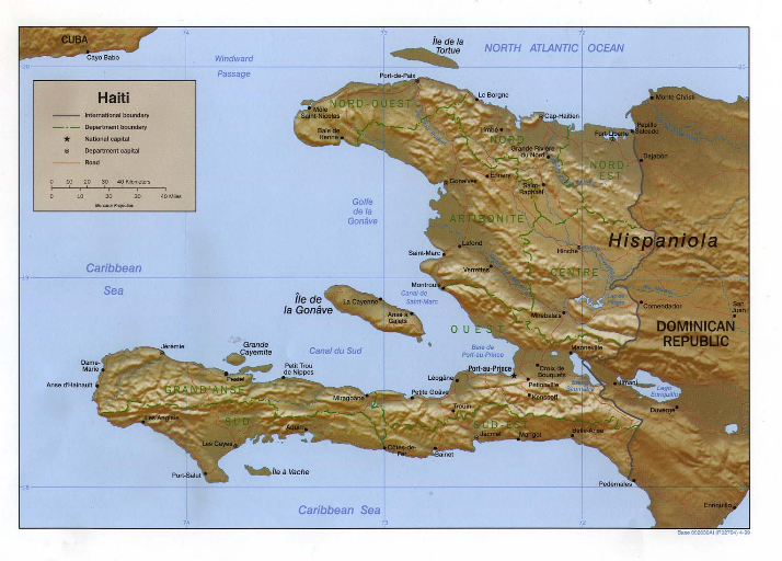
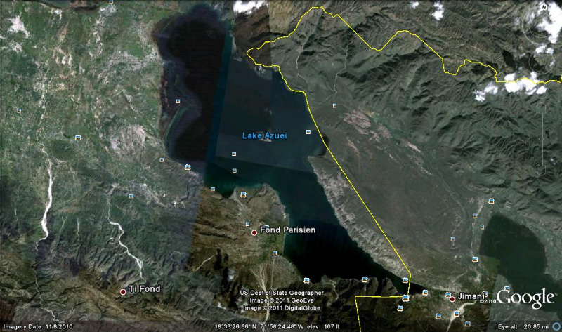
Azuei Lake is located on the arid valley of Cul-de-Sac, East
Port-au-Prince in the department of the West (Figure I). It is
located at 30 km from Port-au-Prince 18 ° 35'31'' North Latitude and
72°00'53'' West Longitude (Pierre, 1980).
3 III.
Methodology
The methodology of this research study consists in literature
review focused the causes of the degradation of Lake Azuei watershed causing
impacts on its ecological balance. To achieve this, we will be collecting
information on the study area (soil, climate, topography, land use) and on the
physico-chemical parameters of Lake Azuei.
3.1 Geology
Lake Azuei constitutes a closed depression, a remnant of
inlets which occupied the plain of the Cul-de-Sac probably during the
Pleistocene (Quaternary) between the mountain
of in Trou d'eau and the Massif de la Selle.
The explanation for the formation of the lake has been assigned by
Woodring et al, 1924, a deposition of alluvial sediments from
the surrounding mountains. This lake is located in an alluvial plain bordered
by mountain ranges mostly carbonate, ground and karstified (landscapes lapiaz)
coral limestone and basalt, with variable topography (Pierre,
2008). It is at a distance about 30 km from the Bay of Port-au-Prince.
Its functioning is related to rainfall and its power by the torrential waters
and karst springs emerging from the massive and very bottom of the lake. The
original side of the bank of the lake is about 20 m, the highest point between
the lakeshore and coastline of the Bay of Port-au-Prince reached 38m where a
vertical drop of 18 m.
3.2 Prevailing Winds
The waters of Lake Azuei are constantly under the influence
steady winds of about 18 to 36 km / h. The prevailing winds are from the
Dominican Republic. During hurricanes, winds raise waves of up to two meters
amplitude (Michel, 2011).
3.3 The rainfall in the study area
The operation of the Lake Azuei is related to rainfall (600 mm
annual average) and its power by the torrential waters and springs emerging
from the massive karst and the lake bottom. During 2007, rainfall measured at
meteorological stations in the Ministère de l'agriculture, des
ressources naturelles et du développement rural
(MARNDR ) at Thomaseau gave 1900 mm against 499 to 800 mm
traditional, three times the average rainfall in the area.
The abundant rainfall in the chain of Trou d'Eau (North side)
is caused the appearance of many sources in the bottom of the Lake Azuei.
According to some experts, the karst structure of Trou d'Eau mountains would
have facilitated the infiltration of rainwater that accumulates in a layer of
clay below and cause the emergence of several underground sources or
underground rivers that would discharge into the Lake Azuei temporarily.
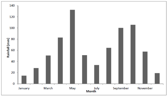
Graph I: Jimani Station Average Monthly Precipitation
(Romero and Poteau, 2011)
3.4 The watersheds of Lake Azuei
The watersheds of Lake Azuei consists of two slopes karstic
mountain ranges (Woodring et al, 1924): the chain of Trou d'eau and the Massif
de la Selle. It is the eastern extension of the chain of Matheux and a branch
of the Sierra de Neiba in Dominican Republic. The chain of Selle is a mountain
range located at south of Haiti. It extends to the Dominican Republic under the
name chain of Baoruco. The lake drains the southern slopes of the chain of Trou
d'Eau from which originate the majority of its sources. It also drains some of
the water that comes from the North Slope of the chain of Selle.
3.5 Hydrology
Lake Azuei is supplied in its periphery by 39 water sources of
karstic origin. In the North, nine of these sources have a total average flow
of 647 l / s. In the South there are sources that the average flow is between
94 l/ s and 140 l / s. It is reported that several sources are underwater. The
water level of the lake varies with the rainy season and hurricane activity. In
1954, after Hurricane Hazel, the lake level rose and then returned to normal
within the eight months that followed. The lake level has been exceeded on
numerous occasions during the 1979-83 period with a storm rising water level of
2 meters above the current level (Thorbjarnason, 1984). But
since 2007, there has been a dramatic increase in water level in Lake Azuei.
3.6 Surface Area and Lake Elevation Change
The surface area of the Lake Azuei fluctuates between 113 to
118 km2 from 1985 to 2002. Surface area of Lake Azuei has increased
about 15% from 1985 levels. After 2003, experienced a clear increasing trend of
surface area increase with Lake Azuei, reaching an area of 132 km2
in 2011 (Table I and Graph II). In Lake Azuei, the larger rate
of surface area increase since 2007 may be related to water levels reaching
lower sloping areas in the northwestern part in the lake.
Lake Azuei
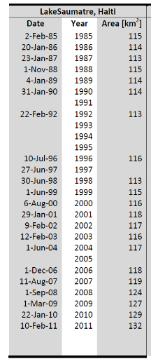
Table I: Time Series of Lake Area Change for Lake
Azuei : Romero and Poteau , 2011
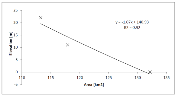
Graph II: Area vs. Elevation: Lake Azuei (Romero
and Poteau, 2011) 2(*)
3.7 Major threats to management of freshwater
ecosystems in Haiti (Ministere de l'Environnement : MDE, 2001)
Threats to management of freshwater ecosystems in Haiti can be
divided into two categories: Direct threats and indirect threats.
a. Direct threats
Over exploitation of the forest resources and erosion of
drainage basins. Forests have been steadily exploited as wood for construction,
as a source of energy ( 71% of the consumption) and as an expendable resource
in the clearing of land for agriculture development. Deforestation is the major
cause of erosion and the most crucial environmental concern of the nation. At
present, of the thirty (30) major watersheds within the country, twenty five
(25) are completely deforested (MDE, 1999). The forest cover
was reduced from 60 % in 1960 to 6.7 % in 1978 (USAID, 1986).
It has been estimated that the percent of the country remained forested
represents less than 3% of the land surface today. The removal of vegetative
cover negatively impacted freshwater ecosystems in Haiti by decreasing their
capacities for sustained production. Non forested land use activities placed at
risk the continued availability of reliable sources of domestic water, created
general denudation of the landscape and increased erosional potential of upper
water areas (MDE, 2001).
b. Indirect threats
They involve socio-economic and institutional factors:
Ø The accelerated population growth coupled with
increasing rate of poverty and uncontrolled urbanization process (shanty town):
The Haitian population will reach 16 million by 2040 according to projections
of the `'Secretairerie d'Etat à la Population''and as already stated the
GNP per capita is $US 250, the lowest GNP in the western hemisphere
(MDE, 2001).
Ø The lack of application of existing laws and land use
control measures to fully protect upper water catchment against illegal
squatting and land clearing;
Ø The lack of application, up to now, of existing
policy in domestic water and its integration into a `'Schéma National
d'Aménagement du Territoire'' and decision making;
Ø The lack, up to now, of official strategy and action
plans for critical wetlands of the country.
3.8 Treats on Lake Azuei
Deforestation associated with heavy agricultural pressures on
marginal farms, accelerating soil erosion, which increases the volume of
sediment carried by streams into the lake (MDE, 2001) Lake
Azuei receives water of watersheds of 110,000 ha. Deforestation and erosion has
accelerated the formation of gullies, the flow capacity of the watershed has
increased from 30 to 40% compared to traditional capacity which was 15 to 20%
in the past. Some references give the watersheds of Haiti following
characteristics: Evaporation 60-70%, 20-25% infiltration, runoff from 25 to
30%. If one assumes that the infiltration and runoff are very strong in the
karst area, it will deduct about 20 to 25% of the watersheds finish their race
in the Lake Azuei (Michel, 2011). According to Patrick Louis,
a geologist, the bathymetric surveys conducted by his institution at the lake
during the last thirty years, reports that the level of sedimentation, for the
period from 1983 to 1990, more than 2 meters.
Retrieved : October 31 , 2011 from
www.haitiwebs.com/showthread.php?t=48496
.
In December 2010, hundreds of fish were dead in the Lake
Azuei. According to initial findings of the investigations, the death of fish
was caused by oxygen deficiency and increasing the level of acidity (pH) in
water following the use of calcareous materials in the work of raising the
stretch of road (linking Haiti to the Dominican Republic) affected by the
rising waters of Lake Azuei. Land use and land cover changes can affect the
physical, chemical and biological characteristics of the soil. Changes in land
use can specifically affect the infiltration capacity: changes from natural or
seminatural vegetation to agriculture or pasture can decrease infiltration
rates (Yimer et al., 2008).
3.9. Lake water Quality
Understanding a lake's physical, chemical, and biological
properties is essential to determining the lake's condition and in making
informed lake management decisions.
According to USEPA (1998), the water quality measurements or
"parameters" most frequently tested in lakes are:
Ø Physical measurements such as water
clarity,
dissolved oxygen, and temperature;
Ø Chemical measurements such as nutrients,
suspended
solids, pH, and conductivity; and
Ø Biological measurements such as chlorophyll
and
bacteria.
3.9.1 Physical Parameters
a. Water clarity or
Transparency: is commonly measured using a Secchi disk, an eight-inch
diameter, weighted disk that is painted black and white in alternate quadrants
and attached to a calibrated rope. The disk is lowered into the water and the
depth at which it is no longer visible is recorded. Secchi disk measurements
reveal how deep sunlight can reach into the water and thereby indicate general
water quality conditions. Hence, Secchi transparency is considered an indirect
measurement of how much algae and sediment is in the water.
b. Dissolved Oxygen measurements determine
the amount of oxygen in the water available for fish and other aquatic life.
c. Temperature measurements
are used to characterize the presence or absence of thermal stratification (the
forming of "layers" of water with distinct temperature differences. Both
dissolved oxygen and temperature measurements are an integral part of a basic
lake assessment.
A lake's temperature variations are important in influencing
what types and how many fish will live and reproduce in that lake. Low oxygen
levels may restrict where fish can go within a lake and limit the types and
numbers of fish in the lake's bottom waters. Generally, warm water fish (e.g.,
bass, bluegill, catfish) need at least 5 milligrams per liter (mg/L) of
dissolved oxygen to survive, while coldwater fish (e.g., trout and salmon)
require 6-7 mg/L.
3.9.2 Chemical Parameters
Nutrients in lakes serve the same basic
function as nutrients in your garden: they help plants grow. In a garden, lush
growth and high productivity are considered beneficial, but this is not
necessarily so in a lake. While some algae and other aquatic plants are
essential parts of a healthy lake ecosystem, elevated nutrient levels can
stimulate nuisance plant growth and lead to an out-of-balance ecosystem and
impaired recreation.
a. Phosphorus is usually the nutrient that
regulates algae growth the most. For many lakes, additional phosphorus loadings
will stimulate additional algae growth. Because phosphorus is so important to
the growth of algae and aquatic plants, many lake and watershed management
activities focus on reducing phosphorus availability in the lake water.
Measuring phosphorus provides an indication of the fertility or "nutrient
enrichment" of a lake. Lakes with low nutrient concentrations are termed
"oligotrophic." Those with intermediate nutrient levels are called
"mesotrophic." Lakes with high nutrient concentrations are termed "eutrophic."
Lakes with extremely high nutrient levels are labeled "hyper-eutrophic." TP
concentrations above 0.030 mg/L are enough to stimulate nuisance algae
growth.
b. Nitrogen forms of
greatest interest to lake studies are nitrate+nitrite nitrogen
(NO3=+ NO2-), total ammonia
nitrogen, and total Kjeldahl nitrogen (total ammonia plus organic nitrogen).
The inorganic nitrogen forms (nitrate and ammonia) are readily utilized by
algae for growth. Researchers have found that inorganic nitrogen concentrations
above 0.30 mg/L are able to stimulate algae growth. Additionally, high ammonia
concentrations are toxic to fish and other aquatic organisms.
Suspended solids: Suspended materials
influence a lake's transparency, color, habitat quality, recreational values,
and overall ecosystem heath. Total suspended solids (TSS) and
turbidity reveal the amount of solids suspended in the water,
and include both inorganic forms (such as soil particles) and organic forms
(such as algae). TSS measures the actual weight of material per volume of
water. Turbidity measurements depend on how much light is scattered or absorbed
by a water sample (more suspended particles cause greater scattering; tinted
water absorbs more light). Turbidity is reported in nephelometric turbidity
units (NTU).
Ions:The amount and types of ions
(positively or negatively charged dissolved minerals) in the water provide
general information on the lake's overall ionic chemistry. Parameters that
describe the ionic makeup of lake water include alkalinity, conductivity, and
pH. They also generally reflect the lake's watershed geology and soil
characteristics.
1. Alkalinity is a measure of the
acid-neutralizing or "buffering" capacity of water. The higher a lake's
alkalinity, the greater its résistance to a decline in pH. Alkalinity
is commonly influenced by bicarbonates and thus is reported as the
concentration of calcium carbonate (CaCO3) in the water. Natural
alkalinities fall within a general range of 20 to 200 mg/L CaCO3.
Illinois lakes typically have high alkalinities and therefore are well-buffered
from the effects of acid rain.
2. Conductivity (specific conductance) is
a measure of the water's ability to conduct an electric current. It is useful
for estimating the concentration of total dissolved solids (TDS) in the water
(TDS equals about 60 percent of conductivity). Because the measurement is made
using two electrodes placed one centimeter apart, conductivity is generally
reported as micromhos per centimeter (umhos/cm). Lakes with high alkalinity
often have high conductivity and vice versa.
The water's pH is a measure of its hydrogen ion
(H+) concentration and reflects the water's acidity. The lower (more
acidic) the pH, the more "free" or "unattached" hydrogen ions in the water. The
pH scale ranges from 0 to 14. A pH of 7 is neutral, less than 7 is acidic, and
greater than 7 is basic or alkaline.
A lake's pH will fluctuate somewhat each day and from season
to season in response to photosynthesis by algae and other aquatic plants,
watershed runoff, and other factors. Like dissolved oxygen concentrations, pH
may change with depth, primarily due to various chemical reactions and a
decrease in photosynthesis.
3.9.3 Biological Parameters
a. Chlorophyll
Chlorophyll is the pigment in plants that allows them to
create energy from light (photosynthesis). There are several forms of
chlorophyll and each absorbs a different wavelength of light. Chlorophyll a
is found in all photosynthesizing plants. For this reason, the amount of
planktonic (suspended) algae in a lake is commonly estimated using the
chlorophyll a concentration. Chlorophyll a should be
"corrected" for phaeophytin a, a common breakdown product of
chlorophyll a that can interfere with its measurement. Analysis for
chlorophyll b and c provides information on the various types
of algae present (blue-greens, green algae, diatoms, etc.).
b. Fecal Coliform
Bacteria
Analysis of bacteria levels at swimming areas is a good public
health practice and it may be required by state, county, or local health
department regulations. Analyses typically are made for fecal coliform
bacteria, or for the particular fecal coliform Escherichia coli (E. coli).
Fecal coliforms are microscopic organisms that live in the intestines of
warm-blooded animals and are excreted in their waste. Coliform bacteria
themselves usually are not disease-causing. However, they are good indicators
for the presence of sewage and animal wastes that may contain disease-causing
organisms and pathogens.
4 IV.
Results
The results reported in the table below are coming from
several different sources and some of them are old. However, they give an idea
about the operating status of the lake in the past. But the exception is made
for those produced by Christian, et al. (2011). They can
provide information on current ecology of the lake.
Table II: The water quality measurements for the Lake
Azuei
|
|
A. Physical Parameters
|
Data available
|
References
|
|
1. Water Clarity or Transparency
|
Average Secchi3(*) depth : 3.25 m
|
Christian, Dorval and Hannigan, 2011
|
|
2. Dissolved Oxygen
|
6.2-8.6 mg/L
|
US Army Corps of Engineers, 1999
|
|
3. Temperature
|
27-30.5 (28,75) OC
|
US Army Corps of Engineers, 1999
|
|
B. Chemical Parameters
|
|
|
|
1. Phosphorus
|
10.58 (#177; 13.82) ug/L
|
Christian, Dorval and Hannigan, 2011
|
|
2. Nitrogen
|
419.02 (#177;19.31 SD) ug/L
|
Christian, Dorval and Hannigan, 2011
|
|
4. Total Dissolved Solids (TSS)
|
7,500 to 10,650 mg/L
|
US Army Corps of Engineers, 1999
|
|
5. Hardness
|
525-2260 mg/L
|
Matthes, 1988
|
|
6. pH
|
7.5-8.1 (8.5)
|
Matthes, 1988
|
|
7. Alkalinity
|
195 - 490 mg/L
|
Matthes, 1988
|
|
8. Salinity
|
6.92 - 15.53 ( ppt)
|
Matthes, 1988
|
|
9. Conductivity
|
500-600 umhos/cm
|
Matthes, 1988
|
|
C. Biological Parameters
|
|
|
|
1. Chlorophyll a
|
2.39 (#177; 0.39 SD) ug/L
|
Christian, Dorval and Hannigan, 2011
|
|
Color of Water ( Code Forel)
|
greenish-40% (phytoplancton)
|
Matthes, 1988
|
The fish kill in Lake Azuei is the result of a series of
biophysicochemical transformations in the lake environment (Table
II). This transformation of natural or anthropogenic causes inevitably
the death of the lake, due to inputs of sediments and nutrients. At first
glance, this event is caused by the phenomenon of eutrophication of the lake.
The mineral nutrients such as nitrogen, phosphorus, etc., depending on their
concentration, operate in the equilibrium with the environment.
These elements are essential to plants, but a drastic
increase in their concentration causes massive growth of algae and aquatic
plants. An eutrophic aquatic environment is an environment rich in nutrients
and with high productivity (Hade, 2002). These processes
result in the change of the pH and the reduction of oxygen in the lake which is
the origin of death of fishes into the lake.
Table III: Classification of Lakes concerning the
trophic level based on OECD (1982)
|
Trophic Level
|
Phosphorus
|
ChlorophyllA
|
Transparence
|
|
Oligotrophic
|
< 10 mg/m3
|
< 2.5 mg/m3
|
6m-12m
|
|
Mesotrophic
|
10-35 mg/m3
|
2.5-8 mg/m3
|
3m-6m
|
|
Eutrotrophic
|
35-100 mg/m3
|
8-25 mg/m3
|
3m-1.5m
|
|
Hypertrophic
|
> 100 mg/m3
|
> 25 mg/m3
|
< 1.5m
|
Organisation for Economic Cooperation and Development (OECD, 1982)
|
These data were (Table III) collected by
Christian et al. (2011 from some samples
collected in the lake, we think they can help to understand what are happened
in the ecological processes of the lake.
Euthrophic: Refers to a water body shallow and
turbid where an excessive concentration of plant nutrients causes algal
blooms.
Oligotrophic: refers to water clear, deep and low
in nutrients. There is little organic matter and a high content of dissolved
oxygen.
Mesotrophic: Refers to a lake enriched by
nutrients, with an early accumulation of sediments and organic matter, which
the water is slightly turbid with a reduction of the dissolved oxygen at depth.
Biological productivity increases and is manifested by the installation of
aquatic plants, an increased presence of algae. Changes in fish community
appear.
Enviromental impacts on Lake Azuei:
Based on the OECD fixed boundary
classification scheme, we classified Lake Azuei as mesotrophic. Secchi depth
indicated euthrophic; chlorophyll indicated oligotrophic; and phosphorus and
nitrogen indicated mesotrophic. But we can consider there is a tendency to an
ecological disruption in Lake Azuei by providing nutrients to the process of
erosion as the surrounding mountains of the lake are highly degraded. In this
case, additional studies will be necessary to understand more on the biological
functioning of Lake Azuei.
5 V.
Conclusions and Recommendations:
Today, the available information we have shows clearly that
the Azuei Lake is threatened by deforestation and degradation of its systematic
watershed (the South side of the chain of Trou d'Eau and the North side of the
chain of Selle). The case of eutrophication potential experienced by the lake
Azuei is not unique. Because runoff carry along a lot of sediment which, by
input of nutrients (P, N), change the ecological balance of the lake. We should
also mention activities such as overfishing, uncontrolled hunting and
agriculture in the immediate area as threats to the proper functioning of the
Lake.
To mitigate the situation, we must:
· Establish a system for collecting data on a regular
basis on the physico-chemical parameters and pluviometric of the lake,
· Conduct research at the hydrogeological system supplied
to the lake to better understanding the process of raising the level of the
lake,
· Engage in political and technical discussions for the
development of a sustainable development and rehabilitation the watershed of
Lake Azuei.
Finally, efforts should also be made to classify Lake Azuei as
a reserved area. In this sense, steps will be taken by the Haitian authorities
to the Ramsar Convention3(*) to make the lake an International Wetland
Area.
6
References
1. Butterlin, J. (1960).
Géologie Générale et Régionale de la
République d'Haïti. Paris: Institut des Hautes Études
de l'Amerique Latine, Université de Paris,
2. Christian, A. D., Dorval, E., Hannigan, R. E.,
(2011). Physical and chemical analysis and classification of
lake Azuei, Haiti. University of Massachusetts Boston, Boston, USA
3. Eva Joelisa Romero Luna And Dina Poteau
(2011). Water Level Fluctuations of Lake Enriquillo and Lake Saumatre
in Response to Environmental Changes. Presented to the Faculty of the Graduate
School of Cornell University In Partial Fulfillment of the Requirements for the
Degree of Master of Engineering, August 2011.
4. Ehrlich, M. ( 1985).
Haiti-Country Environmental Profile-A Field Study. Contract No.
521-0122-C-00- 4090-00, Washington, DC: U.S. Agency for International
Development, June
5. Environmental Protection Agency
(1998). Lake and Watershed Unit, DWPC-, PO. Box 19276,
Springfield, Illmois. 62794-9276: 217/782-3362
6. Gonfiantini R. and. Simonot.
M (1997). Isotope Techniques in
Water Resources Development,«Isotopic Investigation of Groundwater in
the Cul-de-Sac Plain, Haiti.» Proceeding of a symposium, International
Atomic Energy Agency, Vienna, , p. 494
7. Hade André (2002). Nos lacs:
les connaître pour mieux les protéger ; Québec:
Éditions Fides,359p.
8. Ministere de l'Environnement : MDE
(1999) . Haïti : Plan d'Action pour l'Environnement.
MDE-Haiti.
9. MDE (2001). Haiti National Report:
Integrating the Management of Watersheds and Costal Areas in Haiti» Haiti:
MDE, Sep, 2001
10. Matthes, H. (1988). Evaluation de la
situation de la peche sur les lacs en Haiti. Port-au-Prince (Haiti). 84 p. Data
ownerFI /FIRA
11. Pierre M. G. , Emmanuel Molière , Helliot
Amilcar, Simone D. Jn Baptiste et de l'ingénieur Gesner Robert
(2008) . Point de vue de l'Université Quisqueya (UniQ) et
de l'Ecole Nationale de Géologie Appliquée (ENGA) relatif
à la remontée du lac Azuei ou étang saumâtre et de
l'étang de Miragoâne. UniQ/ ENGA
12. Maurrasse, F.J., & C. Jean-Poix (
1997). Transactions, «Hydrologeology of the Water-Supply
Springs of Metropolitan Port-au-Prince, Haiti.» American Geophysical Union
Spring Meeting, Baltimore, Maryland, 27-30 May.
13. Organisation for Economic Cooperation and Development
: OECD (1982). Eutrophication on Waters: Monitoring, Assessment, and
Control. OECD, Paris. 154 pp.
14. Michel R,( 2005). L'espace
caféier en Haïti : déclin et espoir, pages 70 et 71,
Éditions KARTHALA,.
15. Romero, E. J. L. & Poteau, D.
(2011). Water Level Fluctuations of Lake Enriquillo and Lake Saumatre
in Response to Environmental Changes. Presented to the Faculty of the Graduate
School of Cornell University In Partial Fulfillment of the Requirements for the
Degree of Master of Engineering, August 2011.
16. Vlaminck, B. (1989). La pecherie de
l'etang saumatre: Recherche appliquee et activites periode octobre 88-septembre
89.No. HAI/88/003).United Nations Development Programme/Food and
Agriculture Organization (PNUD/FAO). Retrieved October 31 2011 from
http://www.fao.org/docrep/field/003/AC561F/AC561F00.htm#TOC
17. USAID (1986) .Haiti : Country and
Environmental Profile a field study, 130p.
US Army Corps of Engineers
(USACE).(1999). Water resources assessment of Haiti.
18. William, M. (2011). Exploration des
cause de la montee des eaux de l'etang saumatre. Retrieved october 30
2011, from
http://www.jsf-post.com/tag/etang-saumatre/
19. Thorbjarnanson, J.B. (1984): Status and
ecology of the American Crocodile in Haiti. Master's thesis. University of
Florida, Gainesville.
20. WORLD BANK (2000) :Toward
an Environment Strategy for the World Bank
Group: A progress report and discussion draft
21. Woodring, W.P., J.S. Brown, and W.S.
Burbank. (1924) : Geology of the Republic
of
Haiti. Department of Public Works, Baltimore, Maryland:
Lord Baltimore Press,.
22. Yimer, F., Messing, I., Ledin, S. and Abdelkadir,
A. (2008) :, Effects of different land use types on
infiltration capacity in a catchment in the highlands of Ethiopia. Soil Use and
Management, 24: 344-349. doi:
10.1111/j.1475-2743.2008.00182.
* 1 This volume is obtained by
multiplying the average depth (24 m + 5 m / 2 = 14.5 m) by the surface area
(170 km2) of the lake. Note, that these data can be changed if the
shape of the bottom is poorly estimated.
* 2 In this case the authors
want to establish the relationship between the lake surface increase and the
depth (24-25 m). It's like pours some water in a conic recipient, the depth
increases by adding water that increases also surface.
* 1 N.B: A Secchi
disk is a device for measuring the transparency of a body of
water. It consists of a disc of about twenty centimeters, black and white (each
quarter turn). The disc is attached to end of a cord and weighted, is left down
to disappearance then there is the length of the rope. Then hauled the rope up
there and then reappear the length of the rope. The depth of the Secchi disk is
the midpoint between the two measures. Retrieved october 30, 2011 from
www.wikipedia.com .
* 3The Ramsar
Convention is the only global environmental treaty that deals with a
particular ecosystem. The treaty was adopted in the Iranian city of Ramsar in
1971 and the Convention's member countries cover all geographic regions of
the planet. It is an international cooperation for the conservation and wise
use of wetlands and their resources.
| 

