|
NATIONAL UNIVERSITY OF RWANDA
FACULTY OF
SCIENCE
DEPARTMENT OF GEOGRAPHY
OPTION: ENVIRONMENTAL
MANAGEMENT
ACADEMIC YEAR 2012
ENVIRONMENTAL AND SOCIO-ECONOMIC
IMPACTS OF LAND USE CHANGE
IN RWANDA
Case study of Gishwati forest (1970-2011)
A dissertation submitted in partial fulfillment of
academic
requirements for the award of Bachelor?s
Degree in Geography
Option: Environmental Management
By: Jean de Dieu
TWAYIGIRA
Supervisor: Dr.Emmanuel HAVUGIMANA
Huye, July 2012

DECLARATION
I, Jean de Dieu TWAYIGIRA, a student at
national university of Rwanda, faculty of science, department of geography,
option of environmental management, hereby declare that this dissertation
entitled «environmental and socio-economic impacts of land use
change in Rwanda: Case study of Gishwati forest» is my own work,
any other used document is highlighted on the list of references and it has not
been submitted anywhere for the award of any degree.
Name of the student: Jean de Dieu TWAYIGIRA
|
Signature of the student...
|
|
Date:..../...../2012
II
DEDICATION

To my beloved Mother Anastasia NYIRARUVUGO To my brother Jean
Népomuscène UWITIJE
To my sisters
Without your special love and support, I never would have
become who I am today. More than anyone else, I dedicate this work to you.
III
ACKNOWLEDGEMENT
First of all, I thank the Almighty God in heaven that allowed
me, through His grace and mercy, to live in the campus where living conditions
were different.
Especially, I warmly thank my supervisor Dr Emmanuel
HAVUGIMANA to host me and to direct me during my research preparation despite
his other responsibilities which are not easy. Not only that, but also your
hardworking and commitment was an inspiration and a valuable input to my
personality. Thank you for endless cycle of ideas you provided for me.
I am very grateful to the National University of Rwanda for
having provided time for final research preparation. Particularly, I
acknowledge the department staff and lecturers for their full support, before
and during the research process, Thank you for your kindness and guidance to
us.
Sincere appreciation is extended to Mr Gaspard BYUKUSENGE and
his family who gave me encouragement and assistance to join my Undergraduate
studies.
The field survey in mountainous region of Rutsiro district was
an opportunity for me, Environmental Management student to discover the real
world. I highly appreciate and acknowledge Rutsiro for its support.
Finally, my thanks go to all my classmates with whom I shared,
exchanged ideas, and learnt together each and every day. Your moral support was
of great importance.
Jean de Dieu Twayigira
iv
LIST OF ACRONYMS
CGIS : Centre of Geographic Information System
COPARUGI : Coopérative des Agriculteurs de Rundoyi et
Gihira
DEMP : Decentralization Environmental Management Project.
FAO : Food and Agriculture Organization
IUCN : International Union for Nature Conservation
MINAGRI : Ministry of Agriculture
MINALOC : Ministry of Local Government
MINEDUC : Ministry of Education
MINIRENA : Ministry of Natural Resources
MINITERE : Ministry of Lands, Environment, Forestry, water and
Mines
NAFA : National Forest Authority
NISR : National Institute of Statistics in Rwanda
NPK : Nitrate Potassium and Calcium
NUR : National University of Rwanda
ONAPO : Office National de la Population
REMA : Rwanda Environment Management Authority
SNR : Service National de Recensement
SPSS : Statistical Package for Social Sciences
UNEP : United Nations for Environmental Protection
VNP : Volcanoes National Park
v
TABLE OF CONTENTS
DECLARATION i
DEDICATION ii
ACKNOWLEDGEMENT iii
LIST OF ACRONYMS iv
TABLE OF CONTENTS v
LIST OF FIGURES vii
LIST OF TABLES viii
ABSTRACT x
CHAPTER ONE: GENERAL INTRODUCTION 1
1.2. PROBLEM STATEMENT 3
1.3. MOTIVATION 7
1.4. RESEARCH OBJECTIVES 7
1.4.1. GENERAL OBJECTIVE 7
1.4.2. SPECIFIC OBJECTIVES 7
1.4.3. RESEARCH QUESTIONS 8
I.5. RESEARCH HYPOTHESES 9
I.6. SCOPE OF THE STUDY 9
I.7. ORGANIZATION OF THE STUDY 9
CHAPTER TWO: RESEARCH METHODOLOGY 11
2.1. STUDY AREA DESCRIPTION 11
2.1.1. GEOGRAPHICAL LOCATION 11
2.1.2. DESCRIPTION OF BIOLOGICAL COMMUNITIES 11
2.1.3. THE SOCIO-ECONOMIC CONDITIONS OF THE LOCAL POPULATION
11
2.3. DATA SOURCES 13
vi
2.3.1. SECONDARY SOURCES OF DATA 13
2.3.2. PRIMARY SOURCES OF DATA 13
2.4. DATA ANALYSIS AND INTERPRETATION 16
CHAPTER THREE: RESEARCH FINDINGS AND DISCUSSIONS 17
3.1. LITERATURE REVIEW 17
3.1.1. INTRODUCTION 17
3.1.2. DEFINITIONS OF KEY WORDS 17
3.1.3. GENERALITY ON THE FOREST OF RWANDA 20
3.2. PRESENTATION OF RESEARCH FINDINGS AND DISCUSSIONS 22
3.2.1. WHAT DOES LAND USE CHANGE INVOLVE? 23
3.2.2. RELATIVE IMPORTANCE OF DIFFERENT TYPES OF LAND USE CHANGE
24
3.2.3. IMPORTANCE OF FOREST 25
3.2.4. SPATIAL EVOLUTION OF GISHWATI 26
3.2.3. ENVIRONMENTAL IMPACTS 27
3.2.4. SOCIO-ECONOMIC IMPACTS 29
3.2.5. HOW THE FOREST WAS OCCUPIED 33
3.2.6. THE VIEWS OF POPULATION ABOUT FOREST RESTORATION AND
THEIR
LIVELIHOODS 34
3.2.7. THE CURRENT SITUATION OF GISHWATI LANDSCAPE 34
3.2.9. THE PROPOSED SOLUTIONS 37
CHAPTER FOUR: CONCLUSION AND RECOMMENDATION 39
4.1. GENERAL CONCLUSION 39
4.2. RECOMMENDATIONS 40
REFERENCE LISTS 42
APPENDICES xliv
vii
LIST OF FIGURES
Figure 1. Summary of problem statement 6
Figure 2.Flow chart of data collection 12
Figure 3.The concept of sampling 15
Figure 4. Major land uses in the World (%). 19
Figure 5.Reduction of Gishwati forest 21
Figure 6.Spatial evolution of Gishwati (ha) 27
Figure 7.The current status of economy around Gishwati
36
VIII
LIST OF TABLES
Table 1.Sample size for household 16
Table 2.Evolution of forests and natural reserves between
1958 and 2000 (in ha) 20
Table 3.The year of land parcel holding 28
Table 4 .Most effects on the environment 29
Table 5.Major income generation activities 31
Table 6.Medicine plants threatened and what they treat.
32
Table 7.Way of accessing to land into the forest
33
X
ABSTRACT
The aim of this study was to analyze the environmental and
socio-economic impacts of land use change in Gishwati forest. This later is one
among the ones with the highly reduced areas in Rwanda.
The destruction of this forest is nervous. In the 42 years, it
was destroyed so that there remained 2% in 2000. It had an area of 28000ha in
1958 and in 2000 it stayed with only 600ha.
This study revealed some of the consequences that the
surrounding population and environment in general have been subjected to.
To reach the objective of this, various techniques and methods
were undertaken, such as library documentation, field observation and
interviews with different people who are concerned with the environment.
The results showed that the impacts that affected the
population around Gishwati forest are those which have also been caused by some
of these populations themselves.
The pointed out nervous are ecological, socio-economic and
vital such as erosion, flooding, landslides, property losses and reduction in
medicinal plants as well as human losses which has led to a brake with the
national development.
To overcome damage caused by the changes in land uses, the
local population must fiercely struggle so that the restoration could be
sustained; partners may leverage funding in kind of services or other supports
needed to accomplish restoration project.
Key words: Land use, Environment, Forest and
Change
1
CHAPTER ONE: GENERAL INTRODUCTION
I.1. BACKGROUND INFORMATION
Land use can be defined as the» Purposes for which humans
exploit the land cover. It involves both the manner in which biophysical
attributes of the land are manipulated and intent underlying that manipulation;
it means the purpose for which the land is used?. Land use comprises both
natural and human factors. It provides environmental conditions that support
life including human life and it also reflects human activities. While land use
is mainly a direct manifestation of human activities, land cover changes may
result from natural processes or from human activities.
Farming is an important human activity that contributes to
land use change. Approximately 11 percent of the earth?s landmass is now used
for crops. Farming has been changing with rural population increase that
triggered the expansion of cultivated areas and intensification of production.
Some agricultural experts claim that as much as half of 7.2 billion ha of
present forest and grazing land especially in Africa and South America could be
converted to crop production, given the proper inputs of water, fertilizers,
erosion control and mechanical preparation. Although this land could feed
vastly large human population, sustained intensive agriculture could results in
serious environmental and social problems.
Rapidly increasing human population and expanding forestry and
agriculture have brought extensive land use changes throughout the World.
However, in many places it has proven difficult to manage natural forests
because of higher dependency of population on natural resources for
agricultural, energy, nutritional, medicinal, and other needs.
Also natural forests in developing countries are often viewed
as a source of income from timber, oil, mineral exploitation, or tourism by the
government. In addition, inadequate government resources, weak management
capacities and ineffective legal systems have compounded the problem of natural
forest management in developing countries (Salasfky and Wollenberg 2000, in
Masozera, 2002).
2
Humans have affected every part of the Globe. Over the past
few decades, billions of ha of forests, woodlands and grasslands have been
converted to cropland or permanent pasture, but overharvesting, erosion,
pollution and other forms of degradation also have turned large area into
desert or useless scrub. Biodiversity losses resulting from disruption of
natural ecosystems are of great concern. This appears through the cutting down
of forest, overgrazing of grassland and overusing of marginal land.
At the continental level, the climate of Africa especially the
Eastern part supports a variety of forest and woodland cover. Approximately 13
percent of the total land area in East Africa is covered by forest and woodland
and this constituted approximately 5 percent of the total African cover. The
major issue in this sub-region is the conversion of natural forest to
alternative land uses, predominantly cultivation and grazing, although urban
encroachment is also a contributing factor. Clearance of forest and woodland
for agricultural use to feed the growing population is perhaps the single most
important cause of deforestation in East Africa. The impact of deforestation
and degradation of wooded areas include increased potential soil erosion and
loss of soil fertility, alteration of local climatic and hydrological
conditions and changes in biodiversity.
Rwanda?s economy and the livelihoods of its people are
dependent on the environment and natural resources such as water, land, air,
minerals, plants, and animals. These natural resources are increasingly under
pressure from unsustainable use resulting in environmental degradation as well
as decline in ecosystem goods and services that restrict to economic
development (REMA, 2008).
Although concern for the environment is not a recent
phenomenon, management of natural forest in Rwanda has become very complex.
Extreme population pressure on limited available land resources and a decade of
genocide that has resulted in movement and resettlement of population in
protected areas are the major challenges to manage the natural forests. So the
population dynamics have been the point of departure of various transformations
that characterize land use types in Rwanda. The population increase has led to
land clearing for agriculture, Grazing and housing, harvesting of certain plant
species for traditional medical purposes and indiscriminate setting for forest
fires. This has led to environmental degradation in terms of biodiversity
3
(MINITERE, 2003). Environment continues to be degraded at a
rapid pace due to land use change. In 1934, one year after Gishwati forest
reserve founded, the Mukura-Gishwati-Volcanoes forest complex in the north-west
of Rwanda was a single forest block of 833sq km. By 1955 it was divided into
three discrete patches and today only 18 percent of the original forest
remained. In the mid-1970s, Gishwati constituted approximately 280sq km and the
forest was fairly destroyed because of cattle herding (Weber, 1981),
agriculture and settlement. During and after the 1994 war, Rwanda faced the
resettlement of the returnees and internally displaced persons due to the lack
of other public land, community administration decided to utilize the part of
the forest as resettlement sites (MINITERE, 2003). Spontaneous occupation of
Gishwati has led to deforestation and consequently to environmental degradation
(biodiversity loss, soil erosion, and disturbed hydrology) hence disruption in
socio-economic conditions of local population.
1.2. PROBLEM STATEMENT
As many developing countries, Rwanda is also dependent on
agriculture. Over 90 percent of Rwandans are engaged in subsistence
agriculture. In many areas of the country, intensive crop cultivation is a
common practice, which cannot be sustained. It is especially prevalent where
farms have been subdivided several times as they pass from one generation to
another. In many cases, the inherited farm lots are too small, averaging less
than 1 ha to support a family. This fragmentation of family holdings through
generational transfers has led to the expansion of cultivation onto marginal
lands and natural forests. Due to this and other factors pointed out earlier,
natural forests in Rwanda have reduced from approximately 30 per cent at the
turn of the last century to 7 percent of the total land area (Olson et al.1999,
in Masozera, 2002).
However vast natural forest has been affected by anthropogenic
disturbances: forest conversion into pasture, cropland and settlement as shown
in the aforementioned paragraphs. This has resulted in environmental
degradation (Plumptre, Masozera et al. 2002).
Gishwati forest reserve was founded in 1933. Prior to the
Rwandan civil war, Gishwati forest reserve had been heavily affected by human
activities. The forest reserve was in extent approximately 280 sq km in the mid
1970s, of which 100 sq km was converted to pasture and another 100 sq km to
pine plantations in the early 1980s. A 30 sq km area was designated as
4
military zone, leaving only 50 sq km of natural forest. During
and following the war, part of this 50 sq km forest reserve was used for camps
for displaced persons who both settled and farmed within the reserve thereby
leading to its degradation (Plumptre, Masozera et al. 2002).
The increase in population around Gishwati area during the
1980s which led to an increase in livestock numbers hence increasing demand for
grazing, settlement, cropland and fuel wood ( MINITERE, 2005). In addition,
from 1978 to 1994 the Sylvo-pastoral project supported by the World Bank was
the principal cause of degradation with the objectives of converting the bamboo
forests into pasture land, pine and cypresses plantations (Seyler and Masozera,
2002) and accomplishing the agro-forestry and infrastructure activities. It
started first by clearing the trees and replacing them by planting Kikuyu
grass. In order to control the activity, GBK undertook infrastructure
activities such as road construction and building of the Gatindoli centre and
dairy farm in Musenyi.
After 1994, the remaining Gishwati forest was used for the
settlement of refugees, since 1995, people have cleared the forest for
settlement, grazing and crop land. Villages such as Arusha, Kanama, Musenyi,
and Bitenga with an average land holding of 1 ha per household were established
after clearing Gishwati forest. These villages depend largely on agriculture
and livestock for their livelihoods. Due to the increase in the livestock
production and limited pasture land, some used the forest for grazing. As a
result the area was plagued with catastrophic longterm impacts and all of them
aggravate local poverty and lowering the economic development of the region.
These impacts include:
? Reduction of agricultural yields and loss of arable land
(loss of nearly 1 million tons of soil per year) due to decreased soil
fertility and erosion;
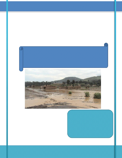
? Increased runoff, landslides and flooding that have claimed
life and caused extensive material damages due to less retention of
rainfall;
? Increased costs of maintenance of power and water supply
infrastructures due to intense siltation and sedimentation;
? Less access to traditional foods, medicines and handcraft
materials;
? Disruption of traditional livestock grazing practices due to
less fodder for livestock;
5
? Fewer opportunities for ecotourism and other future sustainable
economic uses such as decreased availability of wood.
By all these reasons there is a huge environmental change
occurring on this area. So on the research statement of problem is, (i) land
use change in Gishwati area, (ii) destruction of reserve forest, and (iii)
environmental degradation
Therefore this research will be conducted to analyze the
effectiveness of Gishwati land use changes on the environment and
socio-economic conditions of the population around the area in order to be
taken into consideration while implementing and improving the National
Strategies or Project for restoration and sustainable use of the environment.
This information will enable the management authority to save and protect the
remaining forest against unnecessary changes in use then achieve a double
sustainability of Gishwati and human livelihoods.
6
The following diagram summarizes the research problem.
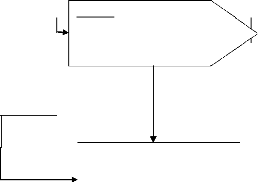
Causes/Human activities
Effects
· Agriculture
· Settlement
· Grazing and fuel wood collection
· Infrastructure activities
· Non- native species plantations
Changes in the land use
Problem
+ Soil erosion &land degradation + Property loses & life
claims + Hydrological alteration
(siltation of water bodies,
shortage in electricity) + Flooding &rising average
temperature
Source: Author, 2012
Needs
o Forest rehabilitation
o Community-based forest management
o Livelihoods diversification
o Environmental education in local population
Figure 1. Summary of problem
statement
7
1.3. MOTIVATION
The choice of this topic has been motivated by two main
reasons which are personal and scientific.
Firstly, Gishwati forest is located in my home region so I am
familiar to this forest. And the forest present indispensable importance both
economic and environmental particularly to the population surrounding the
forest as well as for all Rwandans. Therefore I will be able to analyze the
changes of its use and contribute in giving solutions to these changes. The
focus of this study is to contribute to sustainable management of the
forest.
Secondly, as the area is one of the hotspot in the region with
biodiversity richness, the work will provide some relevant information about
the land use change which alters this biodiversity, specifically on Gishwati
forest in terms of its sustainability and protection from these changes. The
topic has been chosen with the goal of reinforcing my personal knowledge on the
change in land use, especially natural forests with indispensable importance
for the world?s population. Afterword, I was motivated to provision of some
needed information that may play a role in life improvement of human being as
well as to biodiversity.
1.4. RESEARCH OBJECTIVES 1.4.1. GENERAL
OBJECTIVE
The main objective of this research was to analyze the
environmental and socio-economic impacts of forest changes on the local
population.
1.4.2. SPECIFIC OBJECTIVES
In order to achieve the main objective, the following specific
objectives were formulated:
1. To localize and describe changes in natural forest between
1970 and 2011
2. To ascertain the socio-economic and environmental impacts
resulted from these changes
3. To describe the current situation of the landscape.
4. To propose some possible alternative solutions to these
impacts.
8
| 

