Zio basin concentrates dense populations which settle in the
flood plain without any respect to D.G.U.H (Office of town and Habitat
planning) recommendations. These later have for activities agriculture,
breeding, fishing, hunt, trade, forestry exploitation, extraction and washing
gravel. Agriculture is intensified with water reserve (hydro dam) for rice
crop.
The basin is crossed by main road and railway axes (fig.13)
which partly serve the Maritime Region and the country remainder; it is Inter-
State road connecting the coastal zone to Burkina Faso, landlocked country. In
Togblé, the passage on the river required the road bridge installation
of large tonnages; it is same for the railroad which connects cement and
clinker industries in Lome and Tabligbo. The secondary road network made up of
tracks and paths emerge most of the time with the river.
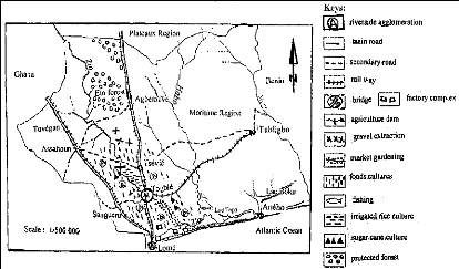
Figure 13: Zio basin tenure (Akibodé, 2000) 4.4
Impacts of human action
According to estimates' of FAO and OIBT (International
Organization of Tropical Wood) during 2000 to 2004, several million forest
hectares disappear in developing countries and this in despite the world forest
community mobilization. In West Africa, more than 2/3 of wooden surfaces
disappeared these last decades. In this context that Zio basin forest
destruction is registered.
The history recalls that it quasi totality of the basin was
covered by an abundant forest, including gallery forest before the human
occupation (GAYIBOR, 1988); just as of other work (ORSTOM, 1967), agree to
recognize vegetable cover importance in pass and devastations operated by the
man. Thus, basin forests degradation led to:
- Marked fall of the soil fertility, made
uncultivated following, an accelerated migration of the fine particles (effects
of deflocculating of clays and dispersion of colloids); none recycling of the
organic matter; an induration's of the pedological profiles;
- River and effluents silting, due to the
important deposits of alluvial loads continuation to the draining making
intermittent the flow and difficult for economic activities depended to the
river exploitation;
- Loss of biological diversity, floristic and
fauna richness basin consequently its economic capital in long term as regards
wood in all its forms, products of fishing and hunting;
- Progressive basin turning into a desert,
justified with the increasingly noticed presence of certain woody species like
Adansonia digitata commonly called «Baobab»
characteristic of the zones strongly touched by the phenomenon;
- Extension of «badlands» reduced cultures
surfaces, leading to the fall of the agricultural outputs and
consequently incomes of the riverside residents.
Taking into consideration of precedes; it can admit that the
vegetable cover is used of natural screen guard or against grounds erosion and
Zio river silting up. The chart below indicates the various sites of the basin
affected by degradation.
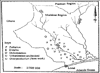
Figure 14: Indicators chart of Zio basin environmental
degradation (Akibodé, 2000)


