1. Remote Sensing, an Overview
1.1. Definitions
Remote sensing can be defined as learning something about an
object without touching it. As human beings, we remotely sense objects with a
number of our senses including our eyes, noses, and ears. ( Cogalton,2010); for
Thomas et al.(2004) ,remote sensing is the science and art of obtaining
information about an object, area, or phenomenon through the analysis of data
acquired by a device that is not in contact with the object, area or phenomenon
under investigation.
The field of remote sensing can be divided into two general
categories: analog remote sensing and digital remote sensing. Analog remote
sensing uses film to record the electromagnetic energy. Digital remote sensing
uses some type of sensor to convert the electromagnetic energy into numbers
that can be recorded as bits and bytes on a computer and then displayed on a
monitor.
1.1.1. Analog remote sensing
The field of analog remote sensing can be divided into two
general categories: photointerpretation and photogrammetry. Photo
interpretation is the qualitative or artistic component of analog remote
sensing. Photogrammetry is the science, measurements, and the more quantitative
component of analog remote sensing. Both components are important in the
understanding of analog remote sensing
1.1.2. Digital Remote Sensing
While analog remote sensing has a long history and tradition,
the use of digital remote sensing is relatively new and was built on many of
the concepts and skills used in analog remote sensing. Digital remote sensing
effectively began with the launch of the first Landsat satellite in 1972. Since
the launch of Landsat 1, there have been tremendous strides in the development
of not only other multispectral scanner systems, but also hyperspectral and
digital camera systems. However, regardless of the digital sensor there are a
number of key factors to consider that are common to all. For Campbell ,(2007)
these factors include:
3
- Spectral Resolution
Spectral resolution is typically defined as the number of
portions of the electromagnetic spectrum that are sensed by the remote sensing
device. These portions are referred to as «bands.»A second factor
that is important in spectral resolution is the width of the bands.
Traditionally, the band widths have been quite wide in multispectral imagery,
often covering an entire color (e.g., the red or the blue portions) of the
spectrum. If the remote sensing device captures only one band of imagery, it is
called a panchromatic sensor and the resulting images will be black and white,
regardless of the portion of the spectrum sensed. More recent hyperspectral
imagery tends to have much narrower band widths with several to many bands
within a single color of the spectrum.
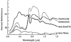
Figure 1 comparison of spectrums of vegetation,bare soil,snow and
water, in Asner et al,2004 - Spatial Resolution
Spatial resolution is defined by the pixel size of the
imagery. A pixel or picture element is the smallest two-dimensional area sensed
by the remote sensing device. An image is made up of a matrix of pixels. The
digital remote sensing device records a spectral response for each wavelength
of electromagnetic energy or «band» for each pixel. This response is
called the brightness value (BV) or the digital number (DN). In Cogalton, 2009;
the range of brightness values depends on the radiometric resolution. If a
pixel is recorded for a homogeneous area then the spectral response for that
pixel will be purely that type. However, if the pixel is recorded for an area
that has a mixture of types, then the spectral response will be an average of
all that the pixel encompasses. Depending on the size of the pixels, many
pixels may be mixtures.
4
Figure 2 : Spatial resolution of different types of sensors,
respectively for spot and Ikonos in Canada center for remote sensing
CCRS,2003
- Radiometric Resolution
The numeric range of the brightness values that records the
spectral response for a pixel is determined by the radiometric resolution of
the digital remote sensing device. These data are recorded as numbers in a
computer as bits and bytes (Jensen, 2007). A bit is simply a binary value of
either 0 or 1 and represents the most elemental method of how a computer works.
If an image is recorded in a single bit then each pixel is either black or
white. No gray levels are possible. Adding bits adds range. If the radiometric
resolution is 2 bits, then 4 values are possible (2 raised to the second power
= 4). The possible values would be 0, 1, 2, and 3. Early Landsat imagery had
6-bit resolution (2 raised to the sixth power = 64) with a range of values from
0 to 63. Most imagery today has a radiometric resolution of 8 bits or 1 byte
(range from 0 to 255). Some of the more recent digital remote sensing devices
have 11 or even 12 bits.
- Temporal Resolution
Temporal resolution is defined by how often a particular
remote sensing device can image a particular area of interest. Sensors in
airplanes and helicopters can acquire imagery of an area whenever it is needed.
Sensors on satellites are in a given orbit and can only image a selected area
on a set schedule. Landsat is a nadir sensor; it only images perpendicular to
the Earth's surface, and therefore can only sense the same place every 16 days.
Other sensors are pointable and can acquire off-nadir imagery.
Figure 3 : temporal resolution movement of a sensor in CCRS, 2003
Table 1 Digital characteristics of some satellite are given below, personal
compilation
|
satellite
|
sensor
|
Ground resolution
|
Radiometric resolution
|
Temporal resolution
|
|
landsat
|
MSS
|
80m
|
-
|
18 days
|
|
landsat
|
Thematic Mapper
|
30 m
|
6 bit
|
16 days
|
|
Spot
|
XS(multispectral)
|
20 m
|
6 bit
|
6 days
|
|
spot
|
panchromatic
|
10 m
|
6 bit
|
5 days
|
|
Ikonos
|
Multispectral
|
4 m
|
11 bit
|
2,9 days
|
5
|
ikonos
|
panchromatic
|
1 m
|
11 bit
|
2,9 days
|
|
Quickbird
|
|
0,5 m
|
11bit
|
1-3,5 days
|
| 

