|

Department of Air
Transport Management
Will ASECNA meet the needs of African
air navigation for the 21st
century?
An analysis of ASECNA strategy for adopting advanced CNS/ATM
MSc THESIS
Academic year 2004-2005 Francis Fabien Ntongo Ekani Supervisor:
Rodney Fewings
CRANFIELD UNIVERSITY
SCHOOL OF ENGINEERING
DEPARTMENT OF AIR TRANSPORT
MSc THESIS
Academic year 2004 - 2005
Will ASECNA meet the needs of African
air navigation
for the 21st century?
An analysis of ASECNA strategy for adopting advanced CNS/ATM
By Francis Ntongo
Supervisor: Rodney Fewings
This thesis is submitted in partial fulfilment of the
requirements for the degree of Master of Science
To My Parents
Abstract
This MSc thesis aims at investigating the rationale of
implementing CNS/ATM1 systems in ASECNA area, a region of the
African continent. The question of whether ASECNA's modernisation strategy will
respond to African air navigation's future needs is essential to the region, as
a performing system is a prerequisite for the viability of air transport
activities.
The study analyses the situation of service provision in the
region and highlights the needs and the priorities. It also assesses the
suitability of future air navigation systems, their ability to respond to these
needs, and it provides an analysis of ASECNA's strategy.
The region is characterised by an insignificant level of
traffic at a global scale. Local air transport industry needs help to reduce
its costs, as the majority of carriers are struggling to survive in a context
of combined low demand, and very high fuel prices. There are a high number of
air navigation incidents relatively to the level of traffic. That is due to an
inefficient system based essentially on conventional navigation systems, which
are very often unreliable and underperforming. The research reveals the
predominance of Safety, Efficiency and airspace Fragmentation as the primary
performance drivers for evolving the system. ASECNA is responding to its users'
needs by implementing future air navigation systems. CNS/ATM trials suggest
that the technology can respond to regional priorities as they bring greater
efficiency, increased capacity and safety, and enhanced cross border
cooperation and cost effectiveness. They are also suitable for inhospitable
areas like in ASECNA.
Local airlines have limited means to upgrade their old fleets.
Foreign carriers operate high yield routes and generate 80 per cent of ASECNA's
revenues and operate young well equipped aircraft. Therefore, the agency has
developed a dual strategy, by maintaining ground-based systems for small local
carriers on domestic routes, while introducing CNS/ATM systems on main areas of
routing.
ASECNA will make the new systems available to its users, but
it will not necessarily be cost effective. However, the success of the
implementation process also depends on the ability of member states to upgrade
and harmonise their legislations on time. The slowness of legislative
procedures and the lack of harmonisation in Africa will delay the benefits,
which is damaging to the industry.
1 Air Traffic Management supported by three
components: Control, Navigation and Surveillance
Acknowledgement
I'd like to thank Rodney, my supervisor, for his
constant support, his wise and constructive critics and all the advices he gave
me and that contributed to the success of this thesis. Andy Foster and Simon
Place also gave me a decisive support.
I'll also like to thank Professor Fariba Alamdari, the
Head of Air Transport Group, for having made me to understand what
management is about: Always being Positive and getting the
best from People.
Special thank to ASECNA for their precious and invaluable
support throughout the project, and for welcoming me during one week at their
Head Quarter in Dakar, Senegal:
Youssouf Mahamat, Director General Amadou Guitteye, Director of
Operations Wodiaba Samake, Head of training office
And
Marafa Sadou, Special adviser to the director of operations
Diallo amadou Yoro, Head of Normalization office
Hilaire Tchicaya, Head of Aeronautical Telecommunication
office
Ngoue Celestin, Head of Air Navigation
Sacramento Martin, Engineer, office of Statistics
Edmond Hocke Nguema-Biteghe, Head of Network
Operations
Armand Boukono, Engineer, Normalization office Ndobian
Kitagoto, Engineer, Meteorology office
|
Aviation companies
Air Benin, Air France KLM
Air Inter Cameroon
Air Madgascar
Air Senegal international
Bellview Airlines, Cameroon Airlines
|
Aéroport Du Cameroun (ADC) Etablissement National de la
Navigation Aérienne (ENNA, Algeria)
|
Table of content
Abstract i
Acknowledgement ii
Table of Content iii
List of figures v
List of tables viii
Glossary ix
Chapter 1 Introduction to thesis page 1
1.1 Background 1
1.2 Research questions 3
1.3 Objectives 4
1.4 Methodology 4
1.5 Structure of thesis 7
1.6 Data sources 7
1.7 Key assumption 7
1.8 Choice of performance measures 8
1.9 Summary 9
Chapter 2 ASECNA's region Air Transport Industry
10
2.1 Economic characteristics 11
2.2 Transport infrastructure 13
2.2.1 Roads 13
2.2.2 Railways 13
2.2.3 Ports 14
2.3 Air Transport Industry 14
2.3.1 Airport Infrastructure 15
2.3.2 Airlines 16
2.3.3 Fleet 17
2.4 Regulatory 25
2.5 Air Travel Demand 26
2.6 Conclusion 32
Chapter 3 Air navigation Performance Review
34
3.1 Introduction 34
3.2 Airspace organization 34
3.2.1 Description of ASECNA's strategy 34
3.2.2 Fragmentation 36
3.3 Traffic 38
3.3.1 Airport activity 38
3.3.2 En-route traffic 40
3.4 Delays 44
3.5 Impact of future trends 44
3.5.1 Prospects 44
3.5.2 Impact on runway capacity 45
3.5.3 Impact on en-route capacity 46
3.6 Traffic complexity 47
3.7 Safety 48
3.7.1 Air Proximities 48
3.7.2 Users' claims 49
3.7.3 Birdstrikes 49
3.7.4 Safety Review System 50
3.8 Efficiency 50
3.8.1 Flight efficiency 50
3.8.2 Fuel efficiency 51
3.9 Cost effectiveness 54
3.9.1 Navigation charges 54
3.9.2 Air Navigation Costs 55
3.10 Cooperation 57
3.11 Training 59
3.12 Financing 59
3.13 CNS and Aviation weather management issues
60
3.13.1 Shortcomings of conventional systems 60
3.13.2 ASECNA's systems' performance 64
3.15 Conclusion 69
Chapter 4 CNS/ATM systems and concepts 70
4.1 Introduction 70
4.2 Suitable CNS/ATM systems for ASECNA 72
4.2.1 Geographic characteristics 72
4.2.2 Efficiency 72
4.2.3 Capacity for Safety 73
4.2.4 Surveillance 73
4.3 Study of selected systems 73
4.3.1 Communications 73
4.3.2 Navigation 83
4.3.3 Surveillance 92
4.3.4 Air Traffic Management 97
4.4 Transition phase 98
4.6 Affordability 99
4.7 Conclusion 100
Chapter 5 Analysis of ASECNA's modernization strategy
102
5.1 Description of the strategy 102
5.1.1 Communications 102
5.1.2 Navigation 103
5.1.3 Surveillance 103
5.1.4 Systems on board the aircraft 105
5.1.5 Aviation weather 105
5.1.6 Air Traffic Management 106
5.1.7 Cooperation 107
5.1.8 Training 110
5.1.9 Financing 110
5.1.10 Implementation schedule up to 2015 112
5.2 Analysis 113
5.3 Conclusion 115
Chapter 6 Recommendations and Conclusion 117
References 122
Appendix 1 Presentation of ASECNA 126
Appendix 2: Ground Based Navigation Systems Principles
130
1 How the VOR works 130
2 How DME works 132
3 How ILS works 133
4 Multilateration 134
Appendix 3 WGS-1984 136
Appendix 4 ASECNA'S Telecommunications Network
137
Appendix 5 Air Traffic Projected Growth by world region
138
Appendix 6 ICAO's Navigation SARPs 139
Appendix 7 ASECNA's Satellite Navigation Circuits
140
Appendix 8 ASECNA'S ATS/Direct Speech Network
141
Appendix 9 CNS/ATM: Drivers and Origins 142
List of Figures
Chapter 1
Figure 1.1 Short term evolution of crude oil 2
Figure 1.2 Analytical Framework of ASECNA's performance analysis
5
Chapter 2
Figure 2.1 ASECNA area in this report 10
Figure 2.2 Share of population and GDP by country 12
Figure 2.3 Stakeholders 15
Figure 2.1 Repartition of Aircraft types in Africa 18
Figure 2.2 Intra African market Fleet (Jets + Turbo Propellers)
19
Figure 2.3 African fleet annual utilization 20
Figure 2.4 African fleet Evolution from 2003 to 2023 21
Figure 2.5 RPK, ASK (Billion) and Passengers load factors in
Africa 21
Figure 2.6 Trend in Aviation fuel cost 23
Figure 2.7 Yields and Unit costs in Key markets 23
Figure 2.8 African Airlines 1 Operating costs (Unit
cost $ per tonne per Km) 24
Figure 2.9 Regional share of global international air passenger
traffic 26
Figure 2.10 Evolution of passenger traffic (1994-2003) 27
Figure 2.11 Average Airport Passenger Traffic (2000-2004) 28
Figure 2.12 Evolution of Cargo traffic (1994-2003) 31
Chapter 3
Figure 3.1 ASECNA's Flight Information Regions 37
Figure 3.2 Number of flights from 1993 to 2003 38
Figure 3.3 Number of aircraft movements at 15 key airports 39
Figure 3.4 Areas of Routing 41
Figure 3.5 Average number of flights controlled per hour and per
controller 43
Figure 3.6 Projected growth over the next decade 45
Figure 3.7 Projected runway occupancy in ASECNA's main airports
46
Figure 3.8 Projected controllers' productivity in 2015 47
Figure 3.9 Evolution of Air Proximities 48
1 Flight Equipment comprises maintenance, insurance,
and rental. The others operating expenses are not mentioned here. But it's
interesting to note that administration unit costs for non efficient airlines
are extremely high, almost twenty times higher than an efficient airline' unit
costs.
Figure 3.10 Evolution of incidents during the last six years
49
Figure 3.11 Flight paths between Douala and Dakar 51
Figure 3.12 The different phases of a flight 52
Figure 3.13 Evolution of air navigation charges 54
Figure 3.14 Personnel, ANS and transport costs from 1996 to 2003
55
Figure 3.15 Evolution of the average cost per flight from 1996 to
2003 56
Figure 3.16 Evolution of en route revenues from 1996 to 2003
57
Figure 3.17 Regional fragmentation of ATM sectors 58
Figure 3.18 Financial results from 1994 to 2003 59
Figure 3.19 OPMET availability rate 68
Chapter 4
Figure 4.1 Communication links in ASECNA 74
Figure 4.2 CPDLC test message 75
Figure 4.3 Estimated capacity gained as a function of % of CPDLC
equipage 76
Figure 4.4 Aeronautical telecommunications network concept 82
Figure 4.5 Comparison between EGNOS and GPS 85
Figure 4.6 Lateral and Vertical Total System Error 87
Figure 4.7 Comparison between RNAV, RNP and conventional
navigation 89
Figure 4.8 Atlanta SID trials: Non RNAV tracks 90
Figure 4.9 Atlanta SID trials: RNAV tracks 90
Figure 4.10 Projected RNP-RNAV capable aircraft 91
Figure 4.11 ADS-B operational capabilities 94
Figure 4.12 ADS-B performances Vs Radar 96
Chapter 5
Figure 5.1 Classification of CNS/ATM expenditure 112
Figure 5.2 Possible Airspace redesign by 2030 115
Appendices
Statutory structure 128
External representations' organisation chart 129
VOR station 131
World Geodetic System 136
ASECNA's Telecommunication Network 137
ASECNA's Satellite connectivity 140
ASECNA's ATS/DS network 141
Evolution of CNS/ATM implementation 145
List of Tables
Table 2.1 Comparative GDP and Population 11
Table 2.2 Situation of aircraft operated in the world 19
Table 2.3 Daily passenger traffic between city pairs 29
Table 2.4 International traffic at major regional airports 30
Table 3.1 The main airstream in ASECNA 40
Table 3.2 Traffic by FIR 40
Table 3.3 Average traffic density from 2001 to 2003 42
Table 3.4 Average traffic density by 2015 46
Table 3.5 Average ANS cost per flight in Europe, ASECNA and the
USA 56
Table 3.6 Equipments availability 65
Table 3.7 Air circulation control: controlled routes 67
Table 4.1 Workload reduction as a function of aircraft equipage
77
Table 4.2 Delays reduction as function of aircraft equipage 77
Table 4.3 Results for lateral and vertical accuracy with EGNOS
87
Table 4.4 Results for availability during trials Vs ICAO's SARPs
87
Table 4.5 ICAO's SARPs for lateral and vertical accuracy 87
Glossary A
ACC Area Control Centre
ADS Automatic Dependent Surveillance
ADS-B Automatic Dependent Surveillance Broadcast mode
ADS-C Automatic Dependent Surveillance Contract mode
AFI Africa Indian ocean area
AFS Aeronautical Fixed Service
AFTN Aeronautical Fixed Telecommunication Network
AIS Aeronautical Information Service
AMS(R) S Aeronautical Mobile-Satellite (R) Service
AMHS Aeronautical Mobile Handling System
AMSS Aeronautical Mobile-Satellite Service
ANSP Air Navigation Service Provider
AOC Airline Operation Centre
APIRG AFI Planning and Implementation Regional Group
APV Approach with vertical guidance
AR Area of routing
ASECNA Agency for Security, Aerial Navigation in Africa and
Madagascar
ASM Airspace Management
ASK Available Seat Kilometre
ATC Air Traffic Control
ATFM Air Traffic Flow Management
ATM Air Traffic Management
ATN Aeronautical Telecommunication Network
ATS Air Traffic Services
ATS/DS Air Traffic Services Direct Speech
C
CDM Collaborative Decision Making
CDMA Code Division Multiple Access
CFIT Controlled Flight Into Terrain
CNS/ATM Communications, Navigation, Surveillance / Air Traffic
Management CPDLC Controller pilot data link communications
D
DECCA A low frequency hyperbolic radio navigation system
DFIS Data Link Flight Information Services
DME Distance Measuring Equipment
E
EGNOS Eurpean Geostationary Navigation Overlay Service
EUR European Region
EUROCAT Thales ATM (Commercial organisation) air traffic
management automation product
F
FAF Final Approach Fix
FANS Future Air Navigation Systems
FIR Flight Information Region
FDPS Flight Data Processing System
FL Flight Level
FMS Flight Management System
G
GLONASS Global Orbiting Navigation Satellite System (Russian
Federation)
GNSS Global Navigation Satellite System
GPS Global Positioning System (United States)
H
HF High Frequency
HFDL High Frequency Data Link
I
IATA International Air Transport Association
ICAO International Civil Aviation Organization
IFR Instrument Flight Rules
ILS Instrument Landing System
INS Inertial navigation system
ITU International Telecommunication Union
L
LORAN Long Range Air Navigation
M
MET Meteorological services for air navigation
METAR Aviation routine weather report
MLS Microwave Landing System
MODE S Mode Select
N
NDB Non-directional beacon
NOTAM Notice To Airmen
NPA Non-precision approach
NSE Navigation System Error
O
OPMET Operational Meteorology
P
PDN Paquet data Network
PIRG Planning and Implementation Regional Group
R
RIMS Ranging Integrity Monitoring Station
RNAV Area Navigation
RNP Required Navigation Performance
RPK Revenue Passenger Kilometre
RTK Revenue Tonne Kilometre
RVSM Reduced Vertical Separation Minimum
S
SAM South American Region
SARPs Standards and Recommended Practices
SAS Scandinavian Airways
SAT South Atlantic
SATCOM Satellite Communication
SBAS Satellite-based augmentation system
SID Standard Instrument Departure
SIGMET Significant Meteorological event
SIGWX Significant Weather
SITA Société Internationale de
Télécommunications Aéronautiques
SSR Secondary Surveillance Radar
T
TACAS Terminal Access Controller Access Control System
TACAN Tactical Air Navigation
TAF Terminal area forecast
TDMA Time Division Multiple Access
TMA Terminal Manoeuvring Area
TSE Total System Error
V
VDL VHF Data Link
VFR Visual flight rules
VHF Very High Frequency
VOR VHF Omnidirectional Radio Range
W
WGS-84 World Geodetic Reference System 1984
Chapter 1 : Introduction to Thesis
The aim of this chapter is to introduce the research topic and to
present the objectives and the methodology used to respond to the research
question.
1.1. Background
Agency for Air Navigation Safety in Africa
(ASECNA1) is a regional publicly held establishment that provides
navigation services to 15 West and Central African Countries2, plus
Madagascar and the Comoro islands in the Indian ocean.
The region is relatively poor. Economic characteristics are those
of developing countries. Some of the less advanced countries are located
there.
ASECNA covers an area of 16 million square
kilometres3, most of which is unoccupied and dominated by the Sahara
desert, oceans and forests.
The Air Transport Industry has changed significantly over the
past decade. These changes were dictated by a combination of factors, mainly
operational and financial, following a succession of crisis4. The
airline industry is increasingly sensitive to the cost of doing business.
Efficiency
Air carriers demand direct routes, flight level optimization,
efficient in-flight and improved en-route fuel5 consumption. Figure
1.1 below shows the projected upwards evolution of crude oil prices. That means
airlines' fuel bill will significantly increase. Cost reduction is one aspect
of mitigating the effects of fuel high price. It explains why airspace users
want more efficiency. It is one of the factors that led them
to incite suppliers, such as air navigation service providers (ANSP) to improve
their effectiveness and the quality of service provision.
1 In the present study designates both the agency or
the geographic region
2 Benin, Burkina Faso, Cameroon, Central African
Republic, Chad, Congo Brazzaville, Equatorial Guinea, Gabon, Ivory Cost, Mali,
Mauritania, Niger, Senegal, Togo. France is also an observer member.
3 Equivalent to almost 66 times Great Britain size.
4 September Eleven, SARS, Bird Flu, Second Golf
War...
5 Crude oil price was around 50 dollars per barrel in
2005
Figure 1.1: Short-term evolution of crude oil
prices
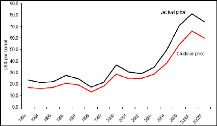
Source: IATA, 2006
Capacity
Air travel and air traffic are continuously growing. The
number of aircraft movements has increased by 5.3 per cent per year on average
over the past 15 years in ASECNA region, which is in line with worldwide
trends. The growth is forecast to continue at an estimated yearly pace of 5 per
cent. That activity means an increasing pressure will be put on airports and
air navigation systems, which may raise airspace and airport capacity
concerns.
Safety
Safety records are worrying in Africa. The
continent represents only about 3 per cent of global traffic.
Nevertheless, statistics show that almost one third of fatal accidents
over the past ten years occurred in Africa according to IATA.
Air Transport is a catalyst for development and trade.
Efficiency, Capacity and Safety of air navigation systems are
therefore strategic components for a viable regional6 air transport
industry and growing national economies.
The important question is whether ASECNA will manage to
overcome the current and future challenges. Will they respond to users'
requirements while delivering a safer service, in the interest of regional air
transport?
The agency has embarked on a modernisation programme since
1994. It is implementing modern air navigation systems, known as Future Air
Navigation Systems (FANS) or CNS/ATM (Control, Navigation, Surveillance and Air
Traffic Management).
CNS/ATM systems are a complex and interrelated set of
technologies and concepts largely based on satellite communication. They are
the response brought forward by the aviation community, under the aegis of the
International Civil Aviation Organisation (ICAO), in response to the challenges
described above. Regional work groups have been put in place to coordinate
efforts. ASECNA is member of AFI7 Planning and Implementation
Regional Group (APIRG), which regroups African and Indian Ocean countries
The thesis intends to investigate current systems' performance
in ASECNA. It highlights regional shortcomings and needs, and examines the
agency's modernisation strategy, CNS/ATM adopted solutions, and their
implications on service provision for the next 15 years.
| 

