5 Results and analysis
5.1 Areas of the city
After visits and interviews, it was possible to determine five
types of areas in the city, with regard to housing, wealth level and type of
sanitation. These areas are presented with, for each of them, an example zone
of the city which was explored in more detail during the research:
1. Established high density housing within flat areas of the
city (A), with for example the zone of Shada.
2. Emerging low density housing areas being built on low lying
reclaimed land (B), exemplified by Petite-Anse.
3. Established low density housing areas built on the slopes
above Cap Haitien (C), with the zone of Mansui.
4. Established high density housing areas built on the slopes
above Cap Haitien (D), with the zone of Bas-ravine.
5. Established better quality housing in wealthier areas (E),
with the zone of Champin.
On top of this, the city centre is a separate case: as the
historical centre of the city, and
the only «legal» part of it in official population
counts, it represents less of a priority for sanitation as houses often have
septic tanks with flush-toilets; solid waste is more of an issue. The city
centre was not taken into account during the study, and is not targeted
by the sanitation project. Table 5.1 on page 34 summarises the
physical differences between the four zones surveyed, and Figure 5.1 represents
these areas on a map.
5.1.1 Established high density housing within flat areas
of the city - A
These areas are typified by Shada, between the «new
bridge» and the airport. It has a boundary of the river to the west and
is build on land reclaimed from the river delta. The housing in Shada is
haphazardly laid out and constructed from cement block and corrugated
galvanised sheet. Large quantities of solid waste accumulate on the river
banks. The common excreta disposal practices used in Shada are
· Open defecation, usually on the river banks on the
accumulations of solid waste.
· Plastic bags, which are then thrown on to the piles
of solid waste or on the roofs.
· Overhanging toilets built on stilts above the
river.
· Public toilets managed by CBOs and financed by the
federation area committees.
5.1.2 Emerging low density housing areas being built on
low lying land reclaimed from mangrove swamps - B
These areas are typified by Petite Anse, which can be divided
into two broad sections; better quality housing situated close to the road and
poorer quality housing being de- veloped on land reclaimed from Mangrove swamps
and the sea. The land is being reclaimed by the dumping of solid waste
purchased for between US$ 4 and US$ 8 a load1. The housing is
currently low density laid out on a rough grid pattern, although this is likely
to change as the density increases. The housing is constructed mainly from
timber frame, wicker and mud walls with roofs.
Open defecation is widely practised and takes place mainly in the
sea or behind the walls of partly built houses.
5.1.3 Established low density housing built on the
slopes above Cap Haitien - C
These areas are typified by Mansui which is situated on the
hill slopes above the middle class housing area of Bel-Air. Part of the land
belongs to the Hotel Beck which no longer operates as the owner died about a
year ago. This has had an impact on the local economy as the hotel employed
many of the residents. The land is steep and there are signs of erosion.
Oxfam staff are concerned that deforestation due to the stripping out
of trees from the hillside for charcoal burning is going to
increase the risk of flooding in
the area at the bottom of the slope. Banana trees, planted by the
local householders, are common.
This area was recently targeted by a USAID-funded latrine
building project which appears to have had mixed results (see Section 5.3.2,
page 45). Those without a latrine
practise open defecation.
1 A truckload of «poor» solid waste
(containing slow-decomposing plastics) can be bought for US$ 4,
a truckload of «better» waste (e.g. the mixture of
sludge and waste blocking drainage channels) is bought for US$ 8; for
comparison, a truckload of earth for building costs around US$ 40.
5.1.4 Established high density housing built on the
slopes
above Cap Haitien - D
These areas are typified by Bas-Ravine which is situated on a
steep hill slope above the city. Houses in this area have been built on a steep
hillside and as the land is becoming limited, they are also beginning to be
built in the ravine bed where they will be very vulnerable to flooding. The
paths in this area are narrow and eroding. Solid waste and plastic bags
containing faeces are routinely thrown into the ravine. Only the houses on
the top of the hill have some land on which they could practise
urban agriculture.
A few public latrines can be found as well as some private
latrines, but plastic bags seem to be widely used.
5.1.5 Established better quality housing in wealthier
areas -
E
These areas are typified by the the Cités (Cité du
Peuple, Champin), mainly situated on
the West bank of the river. They have been built in the 1980s
in a planned manner as cheap accommodation blocks with basic infrastructure for
new immigrants from rural areas. They are characterised by wider streets,
often with concrete on the ground and some drainage channels, however regularly
filled with solid waste. Communal latrines
are placed within each block, but the majority of them is either
full or broken down. As
a result, wealthier people have a latrine or toilet inside
their house while poorer people use plastic bags and go near the river. Latrine
building would be difficult as not so much area is available and many landlords
are absent.
Table 5.1: Summary of differences between the areas
|
Area
Example zone
|
A
Shada
|
B
Petite-Anse
|
C
Mansui
|
D
Bas-Ravine
|
E
Champin
|
|
Housing density
|
High
|
Medium
|
Low
|
High
|
Medium
|
|
Slope
|
Flat
|
Flat
|
Steep
|
Steep
|
Flat
|
|
Ground
|
S & SW
|
M
|
RE
|
RE
|
S & C
|
|
Water table
|
High
|
Very high
|
Low
|
Low
|
High
|
|
Water
|
Trucking
|
HP
|
Springs
|
Springs / HP
|
HP
|
|
City centre
|
Close
|
Remote
|
Remote
|
Close
|
Medium
|
|
Access to road
|
Good
|
Medium
|
Poor
|
Poor
|
Good
|
|
Passageways
|
Narrow
|
Mixed
|
Narrow
|
Narrow
|
Wide
|
|
Urban agriculture
|
None
|
Rarely
|
practised
|
Rarely
|
None
|
|
Wealth
|
Poor
|
Poor/medium
|
Poor
|
Poor
|
Medium
|
|
Population
|
70,000
|
75,000
|
40,000
|
40,000
|
100,000
|
Notes: S = Soil, SW = Solid Waste, M = Mangrove swamps, RE =
Rocky and Eroded,
C = Concrete; HP = Handpumps. «Population» designates
the approximate population
in the same living conditions, according to population data from
2003.
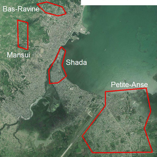
Figure 5.1: Location of surveyed areas in the city
| 

