|
NATIONAL UNIVERSITY OF RWANDA
FACULTY OF
SCIENCE
DEPARTMENT OF GEOGRAPHY
OPTION: ENVIRONMENTAL
MANAGEMENT
ACADEMIC YEAR 2012
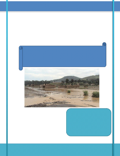
ENVIRONMENTAL AND SOCIO-ECONOMIC
IMPACTS OF LAND USE CHANGE
IN RWANDA
Case study of Gishwati forest (1970-2011)
A dissertation submitted in partial fulfillment of
academic
requirements for the award of Bachelor?s
Degree in Geography
Option: Environmental Management
By: Jean de Dieu
TWAYIGIRA
Supervisor: Dr.Emmanuel HAVUGIMANA
Huye, July 2012

DECLARATION
I, Jean de Dieu TWAYIGIRA, a student at
national university of Rwanda, faculty of science, department of geography,
option of environmental management, hereby declare that this dissertation
entitled «environmental and socio-economic impacts of land use
change in Rwanda: Case study of Gishwati forest» is my own work,
any other used document is highlighted on the list of references and it has not
been submitted anywhere for the award of any degree.
Name of the student: Jean de Dieu TWAYIGIRA
|
Signature of the student...
|
|
Date:..../...../2012
II
DEDICATION

To my beloved Mother Anastasia NYIRARUVUGO To my brother Jean
Népomuscène UWITIJE
To my sisters
Without your special love and support, I never would have
become who I am today. More than anyone else, I dedicate this work to you.
III
ACKNOWLEDGEMENT
First of all, I thank the Almighty God in heaven that allowed
me, through His grace and mercy, to live in the campus where living conditions
were different.
Especially, I warmly thank my supervisor Dr Emmanuel
HAVUGIMANA to host me and to direct me during my research preparation despite
his other responsibilities which are not easy. Not only that, but also your
hardworking and commitment was an inspiration and a valuable input to my
personality. Thank you for endless cycle of ideas you provided for me.
I am very grateful to the National University of Rwanda for
having provided time for final research preparation. Particularly, I
acknowledge the department staff and lecturers for their full support, before
and during the research process, Thank you for your kindness and guidance to
us.
Sincere appreciation is extended to Mr Gaspard BYUKUSENGE and
his family who gave me encouragement and assistance to join my Undergraduate
studies.
The field survey in mountainous region of Rutsiro district was
an opportunity for me, Environmental Management student to discover the real
world. I highly appreciate and acknowledge Rutsiro for its support.
Finally, my thanks go to all my classmates with whom I shared,
exchanged ideas, and learnt together each and every day. Your moral support was
of great importance.
Jean de Dieu Twayigira
iv
LIST OF ACRONYMS
CGIS : Centre of Geographic Information System
COPARUGI : Coopérative des Agriculteurs de Rundoyi et
Gihira
DEMP : Decentralization Environmental Management Project.
FAO : Food and Agriculture Organization
IUCN : International Union for Nature Conservation
MINAGRI : Ministry of Agriculture
MINALOC : Ministry of Local Government
MINEDUC : Ministry of Education
MINIRENA : Ministry of Natural Resources
MINITERE : Ministry of Lands, Environment, Forestry, water and
Mines
NAFA : National Forest Authority
NISR : National Institute of Statistics in Rwanda
NPK : Nitrate Potassium and Calcium
NUR : National University of Rwanda
ONAPO : Office National de la Population
REMA : Rwanda Environment Management Authority
SNR : Service National de Recensement
SPSS : Statistical Package for Social Sciences
UNEP : United Nations for Environmental Protection
VNP : Volcanoes National Park
v
TABLE OF CONTENTS
DECLARATION i
DEDICATION ii
ACKNOWLEDGEMENT iii
LIST OF ACRONYMS iv
TABLE OF CONTENTS v
LIST OF FIGURES vii
LIST OF TABLES viii
ABSTRACT x
CHAPTER ONE: GENERAL INTRODUCTION 1
1.2. PROBLEM STATEMENT 3
1.3. MOTIVATION 7
1.4. RESEARCH OBJECTIVES 7
1.4.1. GENERAL OBJECTIVE 7
1.4.2. SPECIFIC OBJECTIVES 7
1.4.3. RESEARCH QUESTIONS 8
I.5. RESEARCH HYPOTHESES 9
I.6. SCOPE OF THE STUDY 9
I.7. ORGANIZATION OF THE STUDY 9
CHAPTER TWO: RESEARCH METHODOLOGY 11
2.1. STUDY AREA DESCRIPTION 11
2.1.1. GEOGRAPHICAL LOCATION 11
2.1.2. DESCRIPTION OF BIOLOGICAL COMMUNITIES 11
2.1.3. THE SOCIO-ECONOMIC CONDITIONS OF THE LOCAL POPULATION
11
2.3. DATA SOURCES 13
vi
2.3.1. SECONDARY SOURCES OF DATA 13
2.3.2. PRIMARY SOURCES OF DATA 13
2.4. DATA ANALYSIS AND INTERPRETATION 16
CHAPTER THREE: RESEARCH FINDINGS AND DISCUSSIONS 17
3.1. LITERATURE REVIEW 17
3.1.1. INTRODUCTION 17
3.1.2. DEFINITIONS OF KEY WORDS 17
3.1.3. GENERALITY ON THE FOREST OF RWANDA 20
3.2. PRESENTATION OF RESEARCH FINDINGS AND DISCUSSIONS 22
3.2.1. WHAT DOES LAND USE CHANGE INVOLVE? 23
3.2.2. RELATIVE IMPORTANCE OF DIFFERENT TYPES OF LAND USE CHANGE
24
3.2.3. IMPORTANCE OF FOREST 25
3.2.4. SPATIAL EVOLUTION OF GISHWATI 26
3.2.3. ENVIRONMENTAL IMPACTS 27
3.2.4. SOCIO-ECONOMIC IMPACTS 29
3.2.5. HOW THE FOREST WAS OCCUPIED 33
3.2.6. THE VIEWS OF POPULATION ABOUT FOREST RESTORATION AND
THEIR
LIVELIHOODS 34
3.2.7. THE CURRENT SITUATION OF GISHWATI LANDSCAPE 34
3.2.9. THE PROPOSED SOLUTIONS 37
CHAPTER FOUR: CONCLUSION AND RECOMMENDATION 39
4.1. GENERAL CONCLUSION 39
4.2. RECOMMENDATIONS 40
REFERENCE LISTS 42
APPENDICES xliv
vii
LIST OF FIGURES
Figure 1. Summary of problem statement 6
Figure 2.Flow chart of data collection 12
Figure 3.The concept of sampling 15
Figure 4. Major land uses in the World (%). 19
Figure 5.Reduction of Gishwati forest 21
Figure 6.Spatial evolution of Gishwati (ha) 27
Figure 7.The current status of economy around Gishwati
36
VIII
LIST OF TABLES
Table 1.Sample size for household 16
Table 2.Evolution of forests and natural reserves between
1958 and 2000 (in ha) 20
Table 3.The year of land parcel holding 28
Table 4 .Most effects on the environment 29
Table 5.Major income generation activities 31
Table 6.Medicine plants threatened and what they treat.
32
Table 7.Way of accessing to land into the forest
33
X
ABSTRACT
The aim of this study was to analyze the environmental and
socio-economic impacts of land use change in Gishwati forest. This later is one
among the ones with the highly reduced areas in Rwanda.
The destruction of this forest is nervous. In the 42 years, it
was destroyed so that there remained 2% in 2000. It had an area of 28000ha in
1958 and in 2000 it stayed with only 600ha.
This study revealed some of the consequences that the
surrounding population and environment in general have been subjected to.
To reach the objective of this, various techniques and methods
were undertaken, such as library documentation, field observation and
interviews with different people who are concerned with the environment.
The results showed that the impacts that affected the
population around Gishwati forest are those which have also been caused by some
of these populations themselves.
The pointed out nervous are ecological, socio-economic and
vital such as erosion, flooding, landslides, property losses and reduction in
medicinal plants as well as human losses which has led to a brake with the
national development.
To overcome damage caused by the changes in land uses, the
local population must fiercely struggle so that the restoration could be
sustained; partners may leverage funding in kind of services or other supports
needed to accomplish restoration project.
Key words: Land use, Environment, Forest and
Change
1
CHAPTER ONE: GENERAL INTRODUCTION
I.1. BACKGROUND INFORMATION
Land use can be defined as the» Purposes for which humans
exploit the land cover. It involves both the manner in which biophysical
attributes of the land are manipulated and intent underlying that manipulation;
it means the purpose for which the land is used?. Land use comprises both
natural and human factors. It provides environmental conditions that support
life including human life and it also reflects human activities. While land use
is mainly a direct manifestation of human activities, land cover changes may
result from natural processes or from human activities.
Farming is an important human activity that contributes to
land use change. Approximately 11 percent of the earth?s landmass is now used
for crops. Farming has been changing with rural population increase that
triggered the expansion of cultivated areas and intensification of production.
Some agricultural experts claim that as much as half of 7.2 billion ha of
present forest and grazing land especially in Africa and South America could be
converted to crop production, given the proper inputs of water, fertilizers,
erosion control and mechanical preparation. Although this land could feed
vastly large human population, sustained intensive agriculture could results in
serious environmental and social problems.
Rapidly increasing human population and expanding forestry and
agriculture have brought extensive land use changes throughout the World.
However, in many places it has proven difficult to manage natural forests
because of higher dependency of population on natural resources for
agricultural, energy, nutritional, medicinal, and other needs.
Also natural forests in developing countries are often viewed
as a source of income from timber, oil, mineral exploitation, or tourism by the
government. In addition, inadequate government resources, weak management
capacities and ineffective legal systems have compounded the problem of natural
forest management in developing countries (Salasfky and Wollenberg 2000, in
Masozera, 2002).
2
Humans have affected every part of the Globe. Over the past
few decades, billions of ha of forests, woodlands and grasslands have been
converted to cropland or permanent pasture, but overharvesting, erosion,
pollution and other forms of degradation also have turned large area into
desert or useless scrub. Biodiversity losses resulting from disruption of
natural ecosystems are of great concern. This appears through the cutting down
of forest, overgrazing of grassland and overusing of marginal land.
At the continental level, the climate of Africa especially the
Eastern part supports a variety of forest and woodland cover. Approximately 13
percent of the total land area in East Africa is covered by forest and woodland
and this constituted approximately 5 percent of the total African cover. The
major issue in this sub-region is the conversion of natural forest to
alternative land uses, predominantly cultivation and grazing, although urban
encroachment is also a contributing factor. Clearance of forest and woodland
for agricultural use to feed the growing population is perhaps the single most
important cause of deforestation in East Africa. The impact of deforestation
and degradation of wooded areas include increased potential soil erosion and
loss of soil fertility, alteration of local climatic and hydrological
conditions and changes in biodiversity.
Rwanda?s economy and the livelihoods of its people are
dependent on the environment and natural resources such as water, land, air,
minerals, plants, and animals. These natural resources are increasingly under
pressure from unsustainable use resulting in environmental degradation as well
as decline in ecosystem goods and services that restrict to economic
development (REMA, 2008).
Although concern for the environment is not a recent
phenomenon, management of natural forest in Rwanda has become very complex.
Extreme population pressure on limited available land resources and a decade of
genocide that has resulted in movement and resettlement of population in
protected areas are the major challenges to manage the natural forests. So the
population dynamics have been the point of departure of various transformations
that characterize land use types in Rwanda. The population increase has led to
land clearing for agriculture, Grazing and housing, harvesting of certain plant
species for traditional medical purposes and indiscriminate setting for forest
fires. This has led to environmental degradation in terms of biodiversity
3
(MINITERE, 2003). Environment continues to be degraded at a
rapid pace due to land use change. In 1934, one year after Gishwati forest
reserve founded, the Mukura-Gishwati-Volcanoes forest complex in the north-west
of Rwanda was a single forest block of 833sq km. By 1955 it was divided into
three discrete patches and today only 18 percent of the original forest
remained. In the mid-1970s, Gishwati constituted approximately 280sq km and the
forest was fairly destroyed because of cattle herding (Weber, 1981),
agriculture and settlement. During and after the 1994 war, Rwanda faced the
resettlement of the returnees and internally displaced persons due to the lack
of other public land, community administration decided to utilize the part of
the forest as resettlement sites (MINITERE, 2003). Spontaneous occupation of
Gishwati has led to deforestation and consequently to environmental degradation
(biodiversity loss, soil erosion, and disturbed hydrology) hence disruption in
socio-economic conditions of local population.
1.2. PROBLEM STATEMENT
As many developing countries, Rwanda is also dependent on
agriculture. Over 90 percent of Rwandans are engaged in subsistence
agriculture. In many areas of the country, intensive crop cultivation is a
common practice, which cannot be sustained. It is especially prevalent where
farms have been subdivided several times as they pass from one generation to
another. In many cases, the inherited farm lots are too small, averaging less
than 1 ha to support a family. This fragmentation of family holdings through
generational transfers has led to the expansion of cultivation onto marginal
lands and natural forests. Due to this and other factors pointed out earlier,
natural forests in Rwanda have reduced from approximately 30 per cent at the
turn of the last century to 7 percent of the total land area (Olson et al.1999,
in Masozera, 2002).
However vast natural forest has been affected by anthropogenic
disturbances: forest conversion into pasture, cropland and settlement as shown
in the aforementioned paragraphs. This has resulted in environmental
degradation (Plumptre, Masozera et al. 2002).
Gishwati forest reserve was founded in 1933. Prior to the
Rwandan civil war, Gishwati forest reserve had been heavily affected by human
activities. The forest reserve was in extent approximately 280 sq km in the mid
1970s, of which 100 sq km was converted to pasture and another 100 sq km to
pine plantations in the early 1980s. A 30 sq km area was designated as
4
military zone, leaving only 50 sq km of natural forest. During
and following the war, part of this 50 sq km forest reserve was used for camps
for displaced persons who both settled and farmed within the reserve thereby
leading to its degradation (Plumptre, Masozera et al. 2002).
The increase in population around Gishwati area during the
1980s which led to an increase in livestock numbers hence increasing demand for
grazing, settlement, cropland and fuel wood ( MINITERE, 2005). In addition,
from 1978 to 1994 the Sylvo-pastoral project supported by the World Bank was
the principal cause of degradation with the objectives of converting the bamboo
forests into pasture land, pine and cypresses plantations (Seyler and Masozera,
2002) and accomplishing the agro-forestry and infrastructure activities. It
started first by clearing the trees and replacing them by planting Kikuyu
grass. In order to control the activity, GBK undertook infrastructure
activities such as road construction and building of the Gatindoli centre and
dairy farm in Musenyi.
After 1994, the remaining Gishwati forest was used for the
settlement of refugees, since 1995, people have cleared the forest for
settlement, grazing and crop land. Villages such as Arusha, Kanama, Musenyi,
and Bitenga with an average land holding of 1 ha per household were established
after clearing Gishwati forest. These villages depend largely on agriculture
and livestock for their livelihoods. Due to the increase in the livestock
production and limited pasture land, some used the forest for grazing. As a
result the area was plagued with catastrophic longterm impacts and all of them
aggravate local poverty and lowering the economic development of the region.
These impacts include:
? Reduction of agricultural yields and loss of arable land
(loss of nearly 1 million tons of soil per year) due to decreased soil
fertility and erosion;
? Increased runoff, landslides and flooding that have claimed
life and caused extensive material damages due to less retention of
rainfall;
? Increased costs of maintenance of power and water supply
infrastructures due to intense siltation and sedimentation;
? Less access to traditional foods, medicines and handcraft
materials;
? Disruption of traditional livestock grazing practices due to
less fodder for livestock;
5
? Fewer opportunities for ecotourism and other future sustainable
economic uses such as decreased availability of wood.
By all these reasons there is a huge environmental change
occurring on this area. So on the research statement of problem is, (i) land
use change in Gishwati area, (ii) destruction of reserve forest, and (iii)
environmental degradation
Therefore this research will be conducted to analyze the
effectiveness of Gishwati land use changes on the environment and
socio-economic conditions of the population around the area in order to be
taken into consideration while implementing and improving the National
Strategies or Project for restoration and sustainable use of the environment.
This information will enable the management authority to save and protect the
remaining forest against unnecessary changes in use then achieve a double
sustainability of Gishwati and human livelihoods.
6
The following diagram summarizes the research problem.
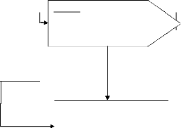
Causes/Human activities
Effects
· Agriculture
· Settlement
· Grazing and fuel wood collection
· Infrastructure activities
· Non- native species plantations
Changes in the land use
Problem
+ Soil erosion &land degradation + Property loses & life
claims + Hydrological alteration
(siltation of water bodies,
shortage in electricity) + Flooding &rising average
temperature
Source: Author, 2012
Needs
o Forest rehabilitation
o Community-based forest management
o Livelihoods diversification
o Environmental education in local population
Figure 1. Summary of problem
statement
7
1.3. MOTIVATION
The choice of this topic has been motivated by two main
reasons which are personal and scientific.
Firstly, Gishwati forest is located in my home region so I am
familiar to this forest. And the forest present indispensable importance both
economic and environmental particularly to the population surrounding the
forest as well as for all Rwandans. Therefore I will be able to analyze the
changes of its use and contribute in giving solutions to these changes. The
focus of this study is to contribute to sustainable management of the
forest.
Secondly, as the area is one of the hotspot in the region with
biodiversity richness, the work will provide some relevant information about
the land use change which alters this biodiversity, specifically on Gishwati
forest in terms of its sustainability and protection from these changes. The
topic has been chosen with the goal of reinforcing my personal knowledge on the
change in land use, especially natural forests with indispensable importance
for the world?s population. Afterword, I was motivated to provision of some
needed information that may play a role in life improvement of human being as
well as to biodiversity.
1.4. RESEARCH OBJECTIVES 1.4.1. GENERAL
OBJECTIVE
The main objective of this research was to analyze the
environmental and socio-economic impacts of forest changes on the local
population.
1.4.2. SPECIFIC OBJECTIVES
In order to achieve the main objective, the following specific
objectives were formulated:
1. To localize and describe changes in natural forest between
1970 and 2011
2. To ascertain the socio-economic and environmental impacts
resulted from these changes
3. To describe the current situation of the landscape.
4. To propose some possible alternative solutions to these
impacts.
8
1.4.3. RESEARCH QUESTIONS
To structure the data collection, the following research
questions were formulated:
1. What are the major changes occurred in Gishwati?
2. To which extent has Gishwati been changed and what are the
driving forces behind? ? These two questions concern the main changes, their
location and their corresponding causes.
3. What are the tremendous socio-economic
effects/consequences of those changes to the environment including local
population?
4. How these changes have affected the livelihoods of local
population?
? These questions relate to outcomes of those land use changes
on the environment and local population.
5. What are the possible solutions to those changes with
regard to the forest sustainability and improved local livelihoods of
population?
9
I.5. RESEARCH HYPOTHESES
The following hypotheses will be tested:
? Settlement development in Gishwati forest was the worst
land use on the population around.
? Local population are being affected by soil erosion and
flooding resulting from the forest changes.
? The integration of socio-economic, educational and
environmental benefits to the human population around is necessary for double
sustainability of Gishwati and human?s livelihoods.
I.6. SCOPE OF THE STUDY
This research is limited to Gishwati forest. And the focus is
put on the changes of Gishwati forest land use from 1970s up to now because it
is during this time that many adverse changes have occurred and impacted the
forest and the surrounding population.
I.7. ORGANIZATION OF THE STUDY
This research is organized under four chapters and the
following sections outline each chapter. Chapter one outlines the general
background information on the land use change that natural forests encountered
as a result of poor or absent management. This includes objectives and
hypotheses pertaining to the study and the key guiding research questions were
set out in order to get answers that assist to reach the main objective of the
research. Research motivation and limitation also are included in this
chapter.
The second Chapter gives an overview of the study area and
details for the methods and materials by which the study was conducted. It
presents also details on the instrumentation, data collection methodology and
analysis techniques, which were used in the whole process. The chapter ends up
by highlighting limitations that were encountered in the research.
The third chapter presents and discusses the detailed results
of the research. Data from the survey questionnaires were computerized,
tabulated and analyzed with the aid of Microsoft Excel, Microsoft word and
statistical packages for social sciences (SPSS). Descriptive statistics such as
mean and percent distributions were generated to summarize the property of the
dataset.
10
Data processing using GIS software have been also carried out
for data analysis and presentation in order to generate maps. The major
patterns in the observations, relationships, trends and generalizations among
the results have been shown. Also some information on the hypotheses test has
been provided.
The last chapter, chapter four highlights the general
conclusion derived from the results and some recommendations or actions to be
taken as a solution from what were found in the research to improve the
protection and management of natural resources specifically Gishwati forest.
11
CHAPTER TWO: RESEARCH METHODOLOGY
This chapter describes how the study was carried out. It
therefore presents the research design, sources of data, various data
collection techniques and methods, data processing and analysis appropriate to
this research.
2.1. STUDY AREA DESCRIPTION 2.1.1. GEOGRAPHICAL LOCATION
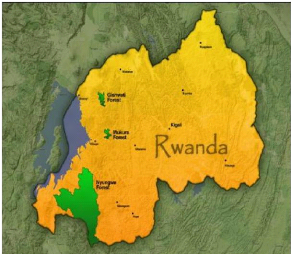
Gishwati forest is located in northwestern part of Rwanda. The
mean slope gradient of the study area is 35 % at an elevation from 2000m to
3000m above sea level, from longitude
29021'40''W to
29028'50''E and latitude
1036'52''N to
1052'17''S (Uwimana, M.F, 2007). It is shared
by three districts Rutsiro, Ngororero and Nyabihu.
2.1.2. DESCRIPTION OF BIOLOGICAL COMMUNITIES
Gishwati is an albertine rift afro montane forest and
constituted an important area of biodiversity. It had a population of
chimpanzees and golden monkeys as well as blue monkeys. It has also a big
number of birds and plants species which are endemic.
2.1.3. THE SOCIO-ECONOMIC CONDITIONS OF THE LOCAL
POPULATION
More than 90% of Rwandans live in rural areas and depend
highly on agriculture (MacMillan, 2005:12). Certain people practice also
livestock. The population on the Congo Nile ridge, at the altitude from 1900 to
2500 m with a rainfall between 1300 and 2000 mm, cultivate essentially sweet
potatoes, maize, beans and peas (ONAPO, 1982:178). Munyensanga (2006:19) said
that the population around Gishwati was about 360000 inhabitants with a density
of 250 to 400 inhabitants by square km. this density which increase
progressively push the population to exploit the forest in order to satisfy
their basic needs (food, pasture) and searching for money by selling the entire
species of trees or by transforming them. The majority of populations live
essentially of agriculture.
12
2.2. RESEARCH DESIGN
|
|
Literature review
|
|
Problem identification
|
|
|
|
|
Problem definition
|
Objectives, research questions and hypotheses
|
Data collection methods
|
Secondary data
Books, journals, articles, reports, maps and photos
|
Primary data
|
|
|
|
|
|
|
|
Detailed information
Concepts, types, causes and impacts of LU change
observation
|
Spatial location of the change
|
Interview and
questionnaire
Local population, districts leaders and forests officers
Conclusion and Recommendation
Figure 2.Flow chart of data
collection
13
2.3. DATA SOURCES
The research objective cannot be achieved without adequate and
needed data. These data will be collected both from secondary and primary
sources of data.
2.3.1. SECONDARY SOURCES OF DATA
Relevant secondary spatial and attributes data will be
collected. Spatial data (shape files) include topographic maps, road networks
and aerial photos. Both personal communication and literature review will be
applied in data collection.
Literature review will focus on published works such as books,
reports, articles, journals, maps, and aerial photographs from both online
resources and libraries such as NUR libraries, and from governmental
institutions such as REMA, NAFA, and some ministries such as MINAGRI, MINIRENA,
etc... In addition to these some information will be delivered from services in
charge of statistics of districts.
The maps from CGIS, MINAGRI or NAFA will be analyzed in order to
interpret them and discover from them the needed information. The image of
Gishwati land cover before 1994 and after will be analyzed in order to detect
the changes. This will serve particular to the analysis of the topography and
the cover/delimitations of the different types of land areas of Gishwati
forest.
2.3.2. PRIMARY SOURCES OF DATA
This approach will involve field observation and survey,
interviews using questionnaires to the randomly chosen sample from the
population around the study area in both Rutsiro and Nyabihu districts. The
oral interviews with the local authorities and districts officers in charge of
forests and environment will be conducted.
In order to get the accurate information, a sample of
questionnaires will also be distributed to the later residents of Gishwati who
were resettled to the other place in Rubavu district and in some cells around
the forest where they have been grouped into imidugudu.
14
2.3.2.1. INTERVIEWS AND QUESTIONNAIRES
This is the commonly used method of collecting information
from people. This will involve the researcher reading the questions to the
respondents and recording their answers in taking notes.
There was any personal interaction, face to face in order to
help respondents to understand well the questions.
A questionnaire is a written list of questions, the answers to
which are recorded by respondents. The questionnaires will be used in the
interview in order to do not lose some of the provided questionnaires when
distributed in the people so that the sample will remain accurate to draw a
conclusion from it.
The interviews were focused on the following:
? People who were shifted from the forest (resettled)
? People who have been living outside and close to the forest
before and nowadays
? People who moved to the forest looking for opportunities as
farmers and so on and
? People with responsibilities of forests management ( local
authorities)
2.3.2.2. SAMPLING TECHNIQUES
Sampling is the process of selecting a few (a sample) from a
bigger group (the sampling population) to become the basis for estimating or
predicting the prevalence of an unknown piece of information, situation or
outcome regarding the bigger group. A sample is a sub group of the population
you interested in.
15

The following figure shows the concepts of sampling
Study
population: sampling units
You select a few sampling units from the study population
Sample
Systematic random sampling was used to get different point of
views on environmental and socio economic impacts of land use change in
Gishwati forest.
From sample findings, you make an estimate of their prevalence in
the study population.
Data collection from these people to find answers to your
research questions.
Figure 3.The concept of sampling
The study area for the interviewing is «a household»
and the sampling method that was used is systematic random sampling to identify
the household to be interviewed and instead of determining the sample range
basing on the universe (population surrounding the study area) and sample size,
the research will consider the size of the sample and the number of
questionnaire copies that were available in each particular area.
That is to say, Sample range (Sr) = sample size/number of
questionnaires
The first interviewee will be selected randomly (n1), then n2=
n1+Sr, n3= n2+Sr, n4=n3+Sr etc until the sampling number is reached.
Thus the total size of the sample was 60 questionnaires in
this research whereby 25 questionnaires have been administered in villages
where people were resettled, 17 questionnaires were for the interviewees who
have been living around and close to the forest, 15 questionnaires for the
people who moved to the forests as farmers, 2 questionnaires for the local
authorities and 1 for the district officer in charge of environment.
16
Table 1.Sample size for household
|
Sector
|
Cell
|
Villages
|
Number
|
|
Ruhango
|
Rundoyi
|
Arusha
|
20
|
|
Kanama
|
16
|
|
Gihira
|
Musenyi
|
12
|
|
Bitenga
|
9
|
|
Authority in charge of environment
|
3
|
The above table highlights the sample size in Ruhango sector
and the systematic random sampling took place in two cells with two villages in
each one.
2.3.2.3. FIELD OBSERVATION
The completion of this research will need the field work by
which the observation, interviews, image capturing and GIS software will
intervene.
2.4. DATA ANALYSIS AND INTERPRETATION
Once data were obtained from the field, they have been cleaned
and analyzed before to be interpreted. Appropriate methods for analysis depend
on the objectives, the study design, and nature of observations. Regarding to
the nature of data, the research found descriptive statistics in the
analysis.
To analyze the data collected, we used SPSS and Microsoft
office excels to generate figure and graphs and then after, these were
interpreted.
17
CHAPTER THREE: RESEARCH FINDINGS AND
DISCUSSIONS
This chapter focuses on literature review and the analysis of
the data collected and the answered questions stated in chapter one. The
general objective of this study was to analyze the environmental and
socio-economic impacts of forest changes on the local population specifically
Gishwati forest in Rutsiro and Nyabihu districts. This chapter targets the
elements that prove relevant findings relating to the changes of Gishwati
forest and its impacts which take into consideration the sampled respondents of
the present study conducted in the aforementioned areas.
3.1. LITERATURE REVIEW 3.1.1. INTRODUCTION
This has explored the literature related to the study.
Different books, journals, articles and reports were investigated to
conceptualize and explore knowledge gap in the study of environmental and
social economic change.
3.1.2. DEFINITIONS OF KEY WORDS
Environment is a complex of external factors
that act on a system and determine its course and form of existence. An
environment may be thought as a superset, of which the given system is a
subset. An environment may have one or more parameters, physical or
otherwise.
Environmental change is a major problem of
the world. The environment of Gishwati has changed since 1930s. Many
researchers tried to focus on different issues and aspects of environmental
change. The extensive farming systems requiring large land areas have
contributed most to encroachment of agriculture land and forest clearance with
increased degradation of land and destabilization of ecosystems.
Mohsen Ahadnejad (2000) , in Khalid Bin Musa (2008) describes
environmental protection is faced a critical problems due to several factors
such as the increasing population, demolishing natural resources, environmental
pollution, land use planning as well as others. Presently unplanned changes of
land use have become a major problem. Most land use changes occur
18
without a clear and logical planning with any attention to
their environmental impacts. Major flooding, air pollution in large cities as
well as deforestation, urban growth, soil erosion, desertification are all
consequences of a mismanaged planning without considering environmental impacts
of development plans. Desertification is a common consequence of improper land
use change.
Land use the relationship between man and
land is inseparably closed. That means, land has been the source of mans food,
shelter, clothes, etc, that is why, people have been using land in many ways
which is changed according to place and time as well as the social and
economical needs of people, so I think man has to know about the land resources
and land use in order to meet his own needs. The term land use has been
attempted to be defined differently from various perspectives by different
scholars. Land use has been seen as a product of interactions between a society
cultural background, skill and its physical needs in one hand and the natural
potential of land on the other hand (Rarn and Kolarkar 1993, in Khalid Bin Musa
(2008). Land use is also defined as people?s activities on land which are
directly related to land (Clawson and Stewart 1965), (Burley, 1961) in Khalid
Bin Musa (2008).
Land cover +land utilization= land use
The barriers of the development are our population and a
limited land resource. Land use is very important both to the user of the land
parcel as well as to understand the environment around. The land use pattern of
an area changes along with time according to need. The changes are related to
the overall functional demand and physical environmental change. Without
knowing the land use changing pattern, it is impossible to make a future
development plan for an area or a region (Khorram et al. 1991, in Khalid Bin
Musa (2008). For the best use of any parcel of land, it is very essential to
know the potentiality of that land resource and the land use changing trend of
that area. At a more mundane level, interaction occurs between everyday
behavior and future land use patterns: existing land use arrangements in part
determine where people live, where they work, and how and when they travel
there, where they shop, where they play, etc., while such behavior in turn
helps to shape future land use patterns (Rhind and Hudson, 1980, in Khalid Bin
Musa (2008). The major land uses worldwide are shown in the below figure.
19
11
cropland
31
26
32
rangeland and
pasture
forests and
woodlands
others
Source: FAO, 1992
Figure 4. Major land uses in the World
(%).
Land cover refers to the surface cover on the
ground, whether vegetation, urban infrastructure, water, bare soil or other. It
is important to distinguish the difference between land cover and land use and
the information that can be assigned from each.
Land use change
As the earth's population increases and national economies
continue to move away from agriculture based systems, cities will grow and
spread. The urbanization often infringes upon viable agricultural or productive
forest land, neither of which can resist nor deflect the overwhelming momentum
of urbanization.
Forestry forests are valuable resource
providing food, shelter, wildlife habitat, fuel, and daily supplies such as
medicinal ingredients and paper. Forests play an important role balancing the
earth's CO2 supply and exchange, acting as a key link between the atmosphere,
lithosphere and hydrosphere. Tropical rainforest in particular house an immense
diversity of species, more capable of adapting to and therefore surviving,
changing environmental conditions than monoculture forests.
20
3.1.3. GENERALITY ON THE FOREST OF RWANDA
The forests of Rwanda have experienced the alarming deforestation
in the last decades which has led to the extinction of the almost their total
surface area.
Table 2.Evolution of forests and natural reserves
between 1958 and 2000 (in ha)
|
Formation
|
1958
|
1970
|
1980
|
1990
|
1996
|
2000
|
now in
%
|
|
Natural forests
|
634 000
|
591 800
|
513 600
|
415 200
|
383 700
|
221 200
|
35
|
|
Nyungwe +
Cyamudongo
|
114 000
|
108 800
|
97 500
|
97 500
|
94 500
|
92 400
|
81
|
|
Gishwati
|
28 000
|
28 000
|
23 000
|
8 800
|
3 800
|
6 00
|
2
|
|
Mukura
|
3 000
|
3 000
|
2 100
|
2 100
|
1 600
|
1 200
|
40
|
|
VNP
|
34 000
|
16 000
|
15 000
|
12 800
|
12 800
|
12 000
|
35
|
|
Akagera NP
|
241 000
|
241 000
|
241 000
|
241 000
|
241 000
|
90 000
|
37
|
|
Hunting domain of Umutara
|
64 000
|
45 000
|
45 000
|
34 000
|
0
|
0
|
0
|
|
Savanna
of the
East +
galleries
|
150 000
|
150 000
|
90 000
|
55 000
|
30 000
|
25 000
|
17
|
|
Planted forest
|
24 500
|
27 200
|
80 000
|
247 000
|
232 500
|
252 000
|
1028 000
|
|
Total
|
658 500
|
619 000
|
593 600
|
696700
|
616700
|
473 200
|
72
|
Source: NISR, 2005
21
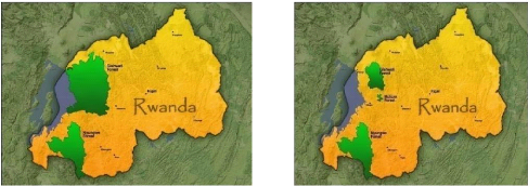
Gishwati forest 1900 Gishwati forest 1980
Gishwati forest 2008
Source: Rutabingwa, 2010
Figure 5.Reduction of Gishwati
forest
22
3.2. PRESENTATION OF RESEARCH FINDINGS AND DISCUSSIONS
When analyzing the impacts of land use change it is important
to understand the different land uses being undertaken in the study region, and
the variety of ways in which they have been changing in recent years. Land use
change is not a simple matter of a shift in the area of land used for a
particular commodity; it may involve a range of changes including change in
what is produced on the land, how it is produced, and the intensity of
production, amongst others.
Understanding land use change requires carefully defining what
is considered to be a land use', so that changes in these land uses
can be examined. Defining a land use can be challenging -- what activities
should be considered to form part of a single land use' when every
land use can be undertaken in many ways? While some sectors and interest groups
may adopt formal definitions of particular land uses, in this study land uses
were defined based on the ways participants defined them in everyday
language.
A wide range of land uses in the interviews, and often used
multiple terms to refer to a particular land use. It was not always clear where
the boundaries of one type of land use ended and another land use began.
Interviewers were therefore asked to discuss the similarities and differences
between different land uses; to assist in defining what should be considered a
single land use, and where an activity may need to be split into more than one
type of land use.
The following key categories of land use are discussed in turn
below. For each, the various ways the land use was defined, and the way it has
been defined for this research based on the discussion held in the interviews,
is described:
? Plantation forestry
? ?Rural residential
? ?Cropping
? ?Grazing enterprises
? Pasture land, pine and cupressus plantations
23
3.2.1. WHAT DOES LAND USE CHANGE INVOLVE?
Land use change was identified as any shift in how land was
used in the region, and could involve any commercial, non-commercial or other
utilization or experience of land considered relevant by interview
participants. This broad definition was used to ensure participants themselves
defined land use change, rather than pre-determining the types of things that
might be considered land use change?.
Land use change is commonly thought of as involving a change
in the amount of land used for a particular purpose. In reality, it is more
complex. Interviewers identified that land use change may involve some or all
of the following:
? Change in the area of land used for a particular purpose
? Change in the number of people employed in different land
use industries
? Changes in the way a land use is undertaken, including the
technology used, efficiency of production and methods of production
? Change in local and regional economic activity dependent on
different land uses, e.g. changes in the types of businesses needed to supply
goods and services, and
? Change in volume and value of goods produced.
This range of types of change is important to recognize. A
change in intensity or efficiency of land use can have socio-economic impacts
that are as significant as those resulting from a change in the total area of
land used for a particular purpose. For example, intensification of a
particular land use such as cropping can result in higher employment per
hectare, and a greater local economic activity due to more inputs being used
and greater volume of outputs being produced per hectare. This may have impacts
as significant as those resulting from a change in the total area of land used
for cropping.
24
3.2.2. RELATIVE IMPORTANCE OF DIFFERENT TYPES OF LAND USE
CHANGE
After listing the land use changes they had observed,
interviewers were asked to prioritize which were the most important or
significant. This was asked in a relatively open way, and when clarification
was requested it was suggested that this should be those land uses which
interviewers considered to have had the greatest or most important impacts (not
necessarily either positive or negative) on the part of the study region they
were familiar with, which they were most enthusiastic to discuss, or which they
felt should be investigated further in the Land Use Change study.
Interviewers were given five stickers, and asked to prioritize
significant land uses by placing their stars against those land uses they felt
were most important. They could choose to put all five stickers against a
single land use, to allocate their stickers to multiple land uses, or to use
only some of their stickers. Once all interviewers had indicated their
priorities, land use changes were ranked from highest importance (those with
the greatest number of stickers) to least (those with few or no stickers).
The land use changes identified as being important?
by many participants in interviews were:
? Increase in area of pine plantations
? Increase in the area of land used for cropping, and a range
of changes in how cropping is undertaken
? Changes in the dairy industry, which varied but included
increase in the area used for dairy farming in some parts of the region,
decreases in other parts, intensification and increasing herd size
? Farm amalgamation (across all types of agriculture),
associated with increased farm size, and increased efficiency enabling a farmer
to manage larger areas
? Increase in rural residential development
As with the process of analyzing land use and land use
changes, the first stage of analysis of impacts involved grouping similar
impacts into categories. While there were important differences in the impacts
described as resulting from different types of land use change, the individual
impacts described could be grouped into the categories of impacts on:
25
+ Local and regional economic activity: spending and flows of
goods and services at the local and regional level.
+ Population and demographics: numbers of residents in region
and in local areas, as well as diversity of these populations with regard to
age, length of residence, income and other salient characteristics.
+ Community interaction and cohesion: the extent to which
members of a community interact, and levels of consensus and conflict in
communities.
+ Employment availability and types: the type and quantity of
jobs available in different industries
+ Other industries: competition between industries for land and
other resources
+ Environmental conditions: condition of soil, streams, and
native vegetation in region + Water use and availability: amount of water
available for domestic and industrial uses + Land prices and markets: change in
the price of land suitable for particular land uses, and
+ Infrastructure condition and use: change in the provision and
condition of infrastructure such as roads, housing, and water distribution
facilities.
3.2.3. IMPORTANCE OF FOREST
Forest and other areas covered by trees play a great role in
the survival of human population; being suppliers of shelters and food for
individuals and animals, water, medicinal plants, construction materials and
fuels (PNUE, 2002:130).
26
Table 3: Main hydrographic networks draining in the
mountainous forests(Runyinya, 1982).
|
Forest
|
Congo basin rivers
|
Nile basin rivers
|
|
Gishwati
|
Nkora Cyimbiri Pfunda Sebeya Bikore
|
Satinskyi Giciye
Nyamukingoro
|
Source: Runyinya, 1982
This table shows the role of forests on the environment and on
rainfall. In this forest some rivers flow to Congo basin via Lake Kivu and
others to Nile Basin via Nyabarongo River.
Forests regulate equally the quality of the soil and water, in
protecting the soil against erosion and contributing to their fertility, in
intercepting rainfall they canalize the flow of water.
In Rwanda, 70% of cultivated land and 60% of pasture land were
threatened by erosion because the slopes are over 5%for cultivated land and 10
% for pasture land (ONAPO, 1982:150).
By the fact of its position in latitude, Rwanda is located in
the equatorial domain. A combination of tropical location and high altitude
ensures that most of Rwanda has a temperate year-round climate
The occidental regions where localized Gishwati forest, are
more arose with a mean of 1800mm of rainfall per year. These high
precipitations expose the land of these regions to the erosion (Hitimana,
2006:15)
3.2.4. SPATIAL EVOLUTION OF GISHWATI
Being attacked by different land uses, Gishwati forest has
became gradually reduced at a rapid pace as shown by the figure below.
27

30000 25000
20000 15000 10000 5000 0
Source: Field survey, author, 2012
Figure 6.Spatial evolution of Gishwati
(ha)
1970 1980 1990 1996 2000 2010
3.2.3. ENVIRONMENTAL IMPACTS
Deforestation is one of the major causes of the enhanced
greenhouse effect. Trees and other plants remove carbon (in the form of carbon
dioxide) from the atmosphere during the process of photosynthesis. Both the
decay and burning of wood release this stored carbon back to the atmosphere. It
can cause the destruction of the habitats that support the biological diversity
thus causing population shifts and extinction. Deforestation generally
increases rates of soil erosion, by increasing the amount of runoff and
reducing the protection of the soil from tree litter.
Forestry operations themselves also increase erosion through
the development of roads and the use of mechanized equipment. Deforestation can
be accompanied by some degree, the gradual reduction of water resources by
deforested region; desertification is an extreme result. Forests support
considerable Biodiversity.
Deforestation percolates into the soil where deforested areas
become sources of surface water runoff, increasing potential for flooding.
Removal of trees does not always increase erosion rates. In
certain regions shrubs and trees have been encroaching on grassland. The trees
themselves enhance the loss of grass between tree
28
canopies. The bare inter canopy areas become highly erodible.
MINIRENA is studying how to restore the former ecosystem and reduce erosion by
planting the trees.
Tree roots bind soil together and act to keep the soil in place.
Tree removal on steep slopes increases the risk of landslides.
All population around Gishwati natural forest has not got a land
parcel in the forest as it is indicated in the following table.
Table 3.The year of land parcel
holding
|
Period
|
Number of respondents
|
%
|
|
Before1994
|
11
|
18.3
|
|
After 1994
|
14
|
23.3
|
|
No parcel
|
35
|
58.3
|
|
Total
|
60
|
100
|
Source: Field survey, author,
2012
Among 25 interviewees with parcel in the forest, 18.3% got the
land before 1994 and 23.3% after 1994 and these are 41.6%of the total
interviewed people. Other 58.3% do not have parcels in the forest but among
them, some use the forest illegally. So the forest has been degraded before and
after 1994 but before 1994 the degradation was not significant as the table
shows. Among 25 with parcels in the forest about 44% got the parcels before
1994 and this shows that the forest began to be threatened before 1994. The 56%
remains have allocated the parcel just after 1994 and the majority of them were
returnees from DRC.
Among 60 interviewees about 53% accepted that the forest has
gradually reduced by the occupation and farming of this before and after 1994
and this resulted into different impacts on environment and socio economic
conditions of the surrounding population.
So the major effects highlighted are shown in the following
table.
29
Table 4 .Most effects on the
environment
|
Answers
|
Effective
|
%
|
|
Landslides
|
23
|
38
|
|
Erosion and flooding
|
17
|
28.3
|
|
Property losses
|
8
|
13.3
|
|
Increase in water salinity
|
12
|
20
|
|
Total
|
60
|
100
|
Source: Field survey, author,
2012
All these factors combined has led to the decline production
of agriculture but also the
availability of other use of water such as hydro electrical
power and domestic use of water and the relevant prove was the flooding in the
Bitenga wetland. It was observed that the district of
Nyabihu is also experiencing significant impacts especially in
Jomba sector whereby the last rainy season 7 persons dead,153 families have
lost their properties and 385 houses have been destroyed according to the
executive secretary of the sector.
After analyzing these results, we concluded that the set of
these impacts has led to the decline of the internal national economy in
general and on the surrounding regions in particular as they carried on the
soil such as:
? Loss in soil fertility for agriculture and grazing
? Loss of forest products
? Gulling
By these results we concluded that the second hypothesis which
states that Local population is being affected by soil erosion and flooding
resulting from the forest changes is confirmed.
3.2.4. SOCIO-ECONOMIC IMPACTS
Some societies are making efforts to stop or slow
deforestation. In Gishwati, where large scale destruction of forests has
occurred the government has required that every able-bodied citizen plants some
trees per year or does the equivalent amount of work in other forest
services.
30
In western countries, increasing consumer demand for wood
products that have been produced and harvested in a sustainable manner are
causing forest landowners and forest industries to become increasingly
accountable for their forest management and timber harvesting practices. Agents
of deforestation can be individuals or groups of individuals that are clearing
the forest. Commercial farmers slash and burn farmers, cattle ranches and
loggers are all agents of deforestation.
Agents are usually acting in their own self interest.
Underlining causes include poverty, lack of land reform. The causes of
deforestation are complex and change over time. Deforestation can be most
easily be understood by studying the causes for each forest and country
separately.
Forests are valuable habitat for wildlife. Direct economic
benefits accrue from the harvest of forest resources such as wildlife, non-wood
products like wild mushrooms, honey and medicinal herbs and from the sale of
hunting and camping equipment.
Forests also play an important role in watershed protection,
soil conservation and the recharge of aquifers.
They can also be the source of new drugs (like taxol) (Gyani
Babu Juwa, 2000, in Khalid Bin Musa (2008).
Although timber production can be an important cause of
deforestation, higher long-term gains can be obtained by managing forest lands
to maintain forest cover. Forests are also important stores of organic carbon,
and forests can extract carbon dioxide and pollutants from the air. Forests are
also valued as a thing of aesthetic beauty and as a cultural resource.
Deforestation results in the loss of these benefits.
«We do not have a definite parcel, according to our
forces we used as enough land as possible because we were there and we did not
have any other soil to exploit in order to satisfy our needs. But actually when
we settled nobody was allocated a plot of more than 1 hectare» said one
interviewee.
As said by the interviewees, they had different income
generation activities in the forests and these are shown in the following
table.
31
Table 5.Major income generation
activities
|
Activities
|
Effective
|
%
|
|
Farming
|
32
|
53.3
|
|
Forest products
|
5
|
8.3
|
|
Grazing
|
17
|
28.3
|
|
Household labor
|
3
|
5
|
|
Other (authority)
|
3
|
5
|
|
Total
|
60
|
100
|
Source: Field survey, author, 2012
About the half of the interviewees generate their incomes from
agriculture and grazing and these two activities were mainly carried in the
forest and these are the most likely to impact on the forest and lead to the
tremendous soil erosion and flooding on the steep slopes of Kanama and other
mountains around the forest. Forest products which accounts for 8.3 % of the
respondents are thought to be a negative impacts on the forest itself but also
on the other biodiversity in the forest.
So, these income generation activities are improving the
livelihoods of surrounding population socially and economically but on the
other hand they harm the environment in which these people live. By doing
these, there was no integration of all factors in order to satisfy the forest
need and to improve the local livelihoods.
As the forest was changed, many species that were used as
traditional medicine were lost completely and this form of medicine has been
highly affected.
32
Table 6.Medicine plants threatened and what they
treat.
|
Scientific names
|
Names
|
Maladies
|
|
Balthasarea schliebenii
|
Umufumbageshi
|
Rheumatism
|
|
Cluta abyssinica
|
Umutarishongi
|
Poison
|
|
Loberia giberroa, milletia
|
Intomvu
|
Poison
|
|
Psilopetala vernonea
|
Umunaniranzovu
|
Kugombora
|
|
Amygdalina
|
Umubirizi
|
Worms
|
|
Physalis peruviana
|
Imbubu
|
Cough
|
Source: Field survey, Author, 2012
The decrease of these plants has made population to walk a
long distance to search for traditional medicine and this leads to the lost
both economically and socially. Other species which were used for wood fire
were also threatened and also had a negative impact on the life of the
population around Gishwati forest. These species include: umusebeya,
umukore, umuyove, umugeshi, umwungo and umushubi.
33
3.2.5. HOW THE FOREST WAS OCCUPIED Table 7.Way of accessing
to land into the forest
|
How
|
Effective
|
% of those with
parcel in Gishwati
|
% of the sample (60 people)
|
|
Governmental authorization
|
4
|
16
|
6.6
|
|
Illegal encroachment
|
9
|
36
|
15
|
|
By inheritance
|
5
|
20
|
8.3
|
|
Buy
|
3
|
12
|
5
|
|
Gift
|
4
|
16
|
6.6
|
|
Total people with
lands into the forest
|
25
|
100
|
41.6
|
Source: Field survey, Author, 2012
The above table shows how people have got the land parcels in
Gishwati natural forest. Among the interviewees with parcels in Gishwati 9%
occupied the forest illegally for grazing and farming it.
Only16 % have been allowed by the local authority to occupy
the land when they returned from DRC as there was no other land to be used by
these refugees. Many of those illegally occupy the land were pushed by the fact
that there was lower production on their own land out of the forest and the
land were very small so they could not satisfy their needs and they wanted to
be near or in the forest where they got fire wood without walking long
hours.
So, they occupy the forest in order to improve their feedings
and economy; as these occupied and used the land for different purposes the
remaining of the population were affected by the impacts caused by these used
forest but also themselves were affected by some of those impacts.
In doing so, 105 families were shifted from Gishwati forest
especially in two villages Kinyenkanda and Karambagiro and were distributed in
other villages of this cell.
34
3.2.6. THE VIEWS OF POPULATION ABOUT FOREST RESTORATION AND
THEIR LIVELIHOODS
The forest restoration was not viewed and agreed at the same
degree by all population because the conservation of this forest may have
adverse social consequences on the local population?s livelihoods even if this
could provide many advantages. These consequences include in among others:
? Deprivation of the communities to the opportunities
necessary for their survival and development, including their basic social
services.
? Lack of guaranteed access to resources is an impediment to a
truly participatory approach at the community levels.
? Local communities may have been subjected to eviction often
with grave consequences to their identity and future development. Indeed
eviction also creates a kind of sociocultural stress.
? Relocated population loses not only the economic base of
their survival but also undergo a considerable reduction of their cultural
heritage due to the temporary or definitive loss of their behavioral models,
their economic activities and their symbols. The living conditions of the
community evicted from the forest can become worse as a direct result of their
dislocation.
? There is no equitable balance between improving biodiversity
conservation and improvements in human well being
3.2.7. THE CURRENT SITUATION OF GISHWATI LANDSCAPE
Despite its heavy destruction, Gishwati forest is being
restored in order to turn it to its original form in biodiversity by making it
an African ecotourism area.
35
A MINALOC commission organized a land sharing process between
returnees and local resettled people in imidugudu. People were given houses,
water tanks and other projects are helping these families and their relatives
to improve their living conditions. These projects include:
? Nurseries of trees which can be planted with other crops and
those which give fruits ? Construction of dairy as they are farmers and this is
a participatory project
? Terracing and other erosion prevention methods in the
mountains surrounding Bitenga zone (Rundoyi and Gihira cells) where they settle
now.
All these projects were established to combat against climate
change by REMA and this zone was selected by this later among the three zones
in the whole country to test the climate change prevention. Population were
asked to be grouped into cooperatives in order to be given money for
implementing these projects but up to now some of these cooperatives have not
legal status and this is a constraint to this program. There is only one
cooperative with legal status (COPARUGI) and this was given the first round of
money for this project.
After being relocated, there was rehabilitation of a big part
of Gishwati which was destroyed through the great apes project of Americans by
planting native species and bamboos surrounded by a belt of Arnos whereby more
than 700 ha have been added to the remained area of Gishwati forest. The people
who have been planted trees such as eucalyptus were obliged to remove them and
this was done successfully. The sawmilling of these trees was allowed but the
charcoal making was prohibited within the forest.
There is also a project for allocating improved seeds of sweet
potatoes replacing maize, fertilizers such as NPK 171717 and pumps for these
sweet potatoes so that there will not be conflicts between the population and
monkeys in the forest by damaging their maize. This project is continuous.
According to the interview with in charge of agriculture in
Ruhango sector, the economy was affected by the changes but after relocation
and rehabilitation, the economy is being increased and this is also agreed by
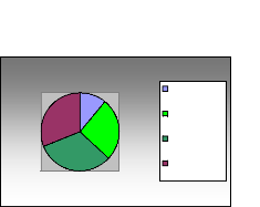
many interviewees as shown in the following figure.
36
35 30
25 20 15 10

5
0
increase decrease no change
Source: Field survey, author, 2012
Figure 7.The current status of economy around
Gishwati
The increase in economy is proved by the following indicators: ?
Improved housing hence less expenditure in maintenance
? Schooling and health center (Bitenga) with a big number of
employees ? Closeness to the authority and this offers many opportunities
The problem of safe drinking water shortage is still faced by
this population but there is a project which will provide them the water.
All these infrastructures were provided by REMA (DEMP),
MINALOC, MINIRENA and the district of Rutsiro.
37
3.2.9. THE PROPOSED SOLUTIONS
People surveyed were proposing the following measures to be
undertaken in order to overcome or to manage the destroyed Gishwati area.
V' Rehabilitation of the Gishwati forest by using the
lost seeds of trees so that they get back their lost services by the forest
such as medicine
V' Hunting and firewood collection prohibition in
Gishwati forest for the survival of different species
V' Terracing around Gishwati forest and use of modern
farming systems in order to fight against the soil erosion and devastating
floods
V' Cultivation of selected seeds which do not
influence conflicts between forest animals and the local population
V' Planting trees on the high mountains surrounding
the forest for water retention and domestic use hence sustainability of the
forest.
38
39
CHAPTER FOUR: CONCLUSION AND RECOMMENDATION
4.1. GENERAL CONCLUSION
Land use change in Rwanda is a very serious phenomenon which
requires an urgent interaction. The direct impacts of this change are more
important and numerous, they affect dairy humans livelihoods and the whole
environment in general.
This change in land use could leads to serious poverty or to
the transfer of mass population towards the favorable regions for their
life.
The main objective of this research was to analyze the
environmental and socio-economic impact of Gishwati forest changes on the local
population. The results revealed that these impacts are more environmental than
socio-economic. Soil erosion and flooding are influencing negatively the
economy of local population and decline the quality of life of these later.
The most impacted part of Gishwati is that which was settled
by the returnees from DRC especially in Ruhango sector as indicated by the
table 4 showing that 25% of interviewees had parcels in the forest, even though
the change began before, it was worsen just after 1994 by the returnees.
A big number of populations have occupied illegally the forest
and use it for different purposes as they had no other enough land out of the
forest to support their life.
These changes had many social consequences linked to the
marginal economy of the population as almost of them practice agriculture. Thus
38% confirmed that effects of these are landslides, 28.3 % highlighted erosion
and flooding as results of forest change and 13.3% confirmed that there are
property losses including roads and houses.
The solution proposed by the population in order to overcome
this problem included tree planting on the steep slopes around the forest which
accounts for about 37, 21 % proposed the forest restoration for recovering the
lost biodiversity and 32 % proposed to do not cultivate in the regions closer
to the forest to prevent the conflicts between forest animals and local
populations.
40
The family forestry also may result in the sustainable use or
conservation of Gishwati forest because if each family owns its own forest,
firewood collection will be reduced in this reserve, hence the sustainable
conservation of biodiversity as highlighted by 10% of the respondent.
During our research, the proposed hypotheses have been
verified and almost all of them have been confirmed.
In fact, our study has shown that the impacts which are faced
by the population around Gishwati forest particular but also to the whole
Rwandan environment as this has revealed to accelerate the speed of climate
change.
4.2. RECOMMENDATIONS
Local communities are of the opinion that the government of
Rwanda should encourage them through job creation, loans, investments,
trainings and other assistance with or on sustainable basis of natural
resources such as forests.
+ In order to protect the population against the impacts of
forest change, the following recommendations have been established:
+ Researchers should proceed to sensitize the population the
protection of environment by use the resources at a slow rate.
+ The government should reinforce development project in rural
areas in order to encourage population to the management of Gishwati forest.
+ Decentralization of REMA towards the sector level should
lower the harm of natural resources especially the use of forest products.
+ MINEDUC should integrate environment education in the
programs of nursery, primary and secondary schools as a way to increase the
level of perception of natural resources management.
+ Private sector and civil society should be engaged to
participate in the green economy.
41
? It is imperative that local communities are adequately
engaged as true agents of change and drivers of sustainable management of
natural resources towards development.
? Partners should assist with monitoring of forest restoration
projects and resources conditions as a critical component of adaptive
management to help identify when an ecosystem?s resilience is reestablished.
? Strengthening institutional frameworks and focused policies
to promote cross sector and participatory approaches to environmental and
natural resources management.
? The use of modern stoves should also be encouraged in order
to slow the use of firewood in the population around Gishwati forest.
42
REFERENCE LISTS Books
1. David Lamb et al, 2005. Restoration of degraded tropical
forest landscapes.
2. Edmund Barrow, Ô et al, (2002). Forest landscape
restoration: Building assets for people and nature, experience from East
Africa 2002, IUCN, and 29p.
3. FAO, (2011). Forests and people.
4. FAO, (1992). Aménagement et conservation des
forêts denses en Amérique tropicale. Rome. 124p
5. Hunter, L. (2000). The environmental implications of
population dynamics.
6. ONAPO, (1982). Actes du colloque «Famille,
Population et Développent», Kigali. 300p.
7. Macmillan, (2005). Atlas du Rwanda, Malaysia. 57p
8. Masozera M. k. (2002). Socioeconomic impact analysis of
the conservation of the Nyungwe forest reserve, Rwanda.
9. Petheram J, Patterson A, Jenkin B, Nettle R (2000).
Socioeconomic impact of changing land use in south west Victoria. Institute
of land and food resources,
university of Melbourne, Melbourne. Online at
http://www.gtplantations.org/publications
accessed on 31 May 2012
10. Ranji,t K., (2011). Research methodology. A step by step
guide for beginners. SAGE, London.
11. REMA (2009). Rwanda state of environment and
outlook. Kigali, Rwanda.
12. Schemer, J., Williams, K., Borschmann, P. and Dunn, C.
(2008). Socio-economic impacts of land use change in the green triangle and
central Victoria.
13. SNR (2005). Recensement Général de la
population et de l'habitat. Analyse des resultants. Perspectives et prospective
démographiques, Kigali. 112p.
14. UNEP (2002). Africa environmental outlook. Past, present
and future perspectives
15. Uwimana, M.F. (2007). Tree species composition for
biodiversity conservation in Gishwati, Butare, Rwanda.
43
16. William, P. C. and Mary, A. C., (2004). Principles of
Environmental Science.
Thesis
17. Bamporiki, P. C., (2007). Impacts de la
dégradation de la forêt naturelle de Gishwati sur la
qualité de la population riveraine, mémoire inédit,
UNR, Butare.
18. Hitimana, A. (2006). Analyse des facteurs de perte de
la biodiversité végétale dans la forêt naturelle de
Gishwati, mémoire inédit, UNR, Butare, 57 p.
19. Khalid Bin Musa (2008). Identifying land use changes
and its socio-economic impact; a case study of Chakoria sundarban in
Bangladesh. Thesis submitted in partial fulfillment of the requirements
for the degree of master programmes in geoinformatics.
20. Munyansanga, F. (2003). Impact de la destruction de
la forêt naturelle de Gishwati sur l'environnement, Mémoire
inédit, UNR, Butare. 120p.
21. Niyonzima, T. (2009). Land use dynamics in the face
of population increase. A study in the districts of Gatsibo and Nyagatare,
Eastern province, Rwanda. Geson.
22. Runyinya Barabwiriza, (1982). Problématique
des réserves écologiques dans un pays á économie
essentiellement agricole. Les forêts de montagne et de volcans du Rwanda,
mémoire de maitrise, Luxembourg, 157p.
Papers
23. IUCN, (2009).IUCN's protected area program.
Retrieved on May 20th, from
http://iucn. Org/about/
work/programs.
24. REMA, (2010). Proceedings of world environmental day
and kwita izina 2010, Kigali. 18p.
25. Rutabingwa, F., (2010). Forestry in Rwanda.
18th commonwealth forestry, Rwanda conference.
44
APPENDICES
xi
Questionnaire guide interview
I am Jean de Dieu TWAYIGIRA, a student at national university
of Rwanda in geography department option of environmental management. I am
conducting an independent final research project entitled
«Environmental and Socio-economic Impacts of land use change in Rwanda
Case study of Gishwati forest» in order to get
Bachelor?s degree in science. The objective of this
questionnaire is to investigate how land use changes have been impact on the
socioeconomic and environmental conditions in Rwanda specifically around
Gishwati forest in western province.
You are chosen to participate because you have been
purposively identified as participant. We would like to request you to kindly
respond the attached questionnaire with honest. All responses provided will be
used only for this research not for any other purpose, and no reference will be
made to individual responses in this survey. The result might help decision
makers to undertake action to solve identified problems.
We would greatly appreciate your frank participation.
Thank you for your contribution.
QUESTIONNAIRE
Village:
Date and time: Respondent:
Age:
Sex:
Occupation (list all)
XII
1. How many people are living in your household?
Number Age
Sex
Education occupation
Section I. attitude questions
1. For how many years have you lived and used this area?
2. Rank the following issues or problems currently facing your
community in order of most important to least important.
|
Problems
|
Most important
|
More important
|
Somewhat important
|
Least important
|
|
Limited land
|
|
|
|
|
|
Limited food
|
|
|
|
|
|
Wild animal
damage to
crops
|
|
|
|
|
XIII
|
Lack of access
to forest
resources/ products
|
|
|
|
|
3. Please tell us what kind of change do the conservation
activities have on you? is it an improvement or a detriment?
4. Does your family benefits from the forest? Yes..... No....
5. What does land use change involve? Section II. Resource
use
1. Do you ever go into the forest and using the forest resources
for your livelihoods?
2. If No why don?t you go there?
a) Fear of rangers d) No time
b) Fear of animals e) Too far
c) No interest f) Other-specify
|
3. If yes why do you go there?
a) Health related
b) Hunting
c) Building materials
d) Firewood
|
e) Grazing
f) Mining
g) Worship
h) Other- specify
|
4. How far (km) was the forest from your village in :
1970 1980 1990 2000
5. Are any of you impacted by the forest change both
directly and indirectly?
Yes No
If yes how (please specify)
6. What were the most changes that have been occurring and
affecting your livelihoods?
7. Are these change environments friendly? Explain how.
xiv
8. Are the forest products collected for the market or
household consumption? If for the market, what quantity of the products is sold
and how many do you gain from these products?
9. Discuss the impacts of different land use changes?
10. What do you think about the forest restoration and your
livelihoods?
11. What do you think tourism industry will benefit you?
a) Sell handcrafts
b) Act as a tour guide/porter
c) Other- specify
12. Compare the situation before the forest has been settled
and after being settled. Was there any improvement or a detriment?
Section III. Socio-economic questions
1. How big is the size of the land under control of your
household (ha)?
2. What are the main sources of income for your household?
a) Sale of farm produce (specify which crops or animal
products)
b) Sale of household labor (specify where sold, and if male or
male)
c) Sale of forest products
d) Remittances from daughter/son/relative-specify
e) Petty trade (specify type of trade and who in the household
does it)
f) Others (specify)
3. Is there anything you lost because of the forest changes?
Yes No
If yes what and how
4. How do you rate your situation now from the changes were
limited?
a) Better off
b) Same as before
xv
c) Worse off
5. Is there any relationship between the forest change and the
erosion and flooding that this region is being experiencing?
6. a. How was the situation before you settled the forest? b.
How did you settle the region? Is it by you or by the government?
District/Sector officers
1. What did you do to save the life of the people installed in
Gishwati and their properties?
2. What were the worst effects of the forest change on your
local population and the environment in general? And why this?
3. Estimate how much did you lost economically and
environmentally from the forest change? Did the economy increases or
decreases?
4. There must be some conflicts between the forest
restoration and the local communities, what are they and how or what strategies
are in place to reduce these conflicts?
5. In your opinion how do you think the forest should be used
and how should people benefit from instead of being damaged by its use?
THANK YOU FOR RESERVING THIS TIME TO THIS
INTERVIEW!!!!!!!
16
| 

