CHAPTER III: RESEARCH METHODOLOGY
3.1 The area of study
3.1.1 Localisation
Mono River system is the largest river system in Togo with
catchments area of 21500 km2; it serves as eastern boundary between
the Yoto district and the Republic of Benin. The district is located in
South-Eastern Togo, North-East of the Maritime region. It is geographically
bound by latitude 6°30` and 6°60`N, longitude 1°20` and
1°35`E. It is bordered by the Haho district to the north, Bas-Mono and the
Vo districts to the south, the Zio districts to the west and Republic of Benin
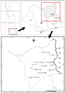
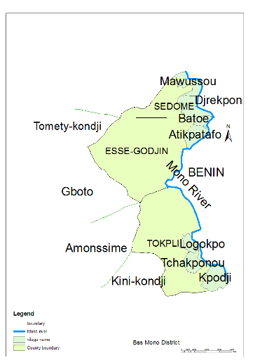
to the east. The study was conducted in the downstream area of the Mono River
basin in eight villages of Sedome (Mawussou, Djrekpon, Batoe), Esse-Godjin
(Tofakope, Atikpatafo), and Tokpli (Kpodji, Tchakponou-kondji and Logokpo)
counties, in the Yoto district "Map 1" .The selected villages fall under the
hazard prone area, where populations have been affected, especially during 2010
flood event, providing then a better study population who can help us to
generate a better view on the assessment conducted.
3.1.2. Landscape, soil and
vegetation
The study area is formed by hydromorphous soils which are
rapidly saturates of water. The sand contents decreases, depending on the
closeness of the area to the river. The geology consists of the continental
shelf called the terminal plate which extends from Kouvé area to the
north-western of Sedome.
The vegetation is a savannah and is composed of the classified
and gallery forests and various grassland grasses.
The fauna consists of mammals (buffalo, warthogs, monkeys, deer,
agouti etc.) and various birds of prey, aquatic life, crocodiles and hippos.
Plateau Region
Zio District
Bas-Mono
District
Vo District
Map 1: Map showing the targeted villages
3.1.3. Climate and Hydrology
The study area, which is at an altitude that ranges from 17 to
55 meters above sea level, has Guinean sub-equatorial climate with two distinct
rainy seasons separated by dry periods which are influenced by the movement of
two (2) types of winds at different times of the year. The mean annual
temperature ranges from 22°C to 30°C and precipitation varies
between 800mm and 1200 mm/year; this usually peaks in May-June and
September-October. The Mono River has a pluvial law which has changed in the
downstream part of the basin due to the construction of Nangbéto dam in
1987 for hydroelectric purposes. Thus, it passed from the irregular to a
relatively regular flow due to the release of water of the dam. Before the
construction of the Nangbéto dam, the Mono River presented the phases of
low water with null flow and height from mid-December to the third week of May,
whereas from May until December the river experienced high flow with average
maximum of (450 m3/s) in September. This is changed after the construction of
the dam with a relatively permanent out-flow at the downstream part ( Ago et al
2005).
3.1.4. Population and
Economic Activities
The study area is made up of three
counties (Sedome, Esse-Godjin and Tokpli). According to the Togo Population and
Housing Census Report in 2010, the total population of the three counties was
estimated at about 34918 with 10803 in Sedome, 9261 in Esse-Godjin and 14854 in
Tokpli. The majority of the population is located in the River floodplains.
Agriculture is the most important activity being carried out in the area with a
majority of the people living practising subsistence farming.
| 

