4.3.4. Composite
vulnerability index of vulnerability factors
4.3.4.1. Exposure
factor
Exposure considers the indicators which explain how social
entities such as households or economic activities like agriculture, etc., are
exposed to flood events. Ten (10) indicators are used to explain the
determinant of communities' vulnerability to flood disaster under exposure
factor. Two main determinants are found: flood characteristics composed of
flood frequency, magnitude, depth and duration as well as elements at risks
composed of households and their farmland. Flood characteristics are quite the
same for all the surveyed village but the difference is related to the elements
at risk in each village. The composite vulnerability index of this factor is
calculated for each village. By considering the composite index of exposure
factor, the most exposed villages are Djrekpon and Kpodji with high indices
ranging from 0.0451 to 0.0651 "Map 3". The most exposed villages have the
highest scores for most of the considered indicators under the elements at risk
compared to the other villages : high population and farmland in flooded area,
high percentage of women and children and elderly in flooded area "annexe 6".
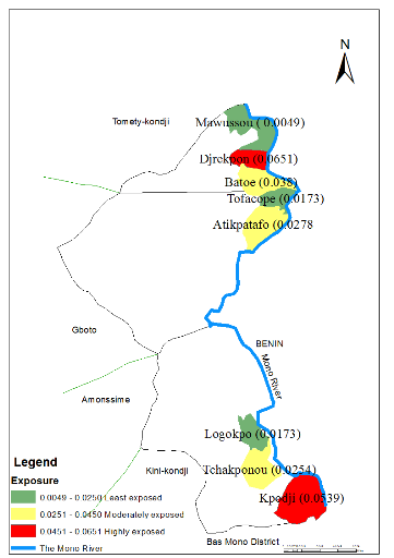
Map 3: Flood Exposure map
of the study area
4.3.4.2 Susceptibility
Factor
Susceptibility considers the indicators which evaluate the
sensitivity of an element at risk before and during a flood event. Eleven (11)
indicators are also equally used to explain the determinants of communities'
vulnerability to flood disasters under susceptibility factors. The composite
index of susceptibility factor for each village is computed. By considering the
composite index of susceptibility factor, the most susceptible villages are
Batoe and Atikpatafo with high indices ranging from 0.0058 to0.0065 "Map 4".
The most susceptible villages have the highest scores for most of the
considered indicators :high female headed household, low education level,
limited livelihood strategies, high household size, low coping capability, low
access to emergency service, low preparedness capability "annexe 6".
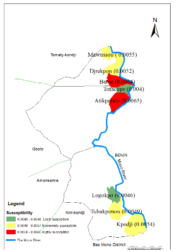
Map 4: Flood Susceptibility
Map of the study area
4.3.4.3 Resilience
Factor
Resilience factor considers indicators which clarify the ability
of a Human-Environment system to persist if exposed to flood by recovering
during and after the event. Eight (08) indicators have been used to explain the
determinants of communities' vulnerability to flood disasters under resilience
factor. The composite index of susceptibility factor for each village is
computed. By considering the composite index of resilience factor, the least
resilient villages are Djrekpon, Tchakponou and Kpodji with indices ranging
from (0.0059- 0.0069 ) "Map 5". The least resilient villages have the lowest
scores for most of the considered indicators :Low knowledge on warning system,
low evacuation capability, low recovery capacity "annexe 6".
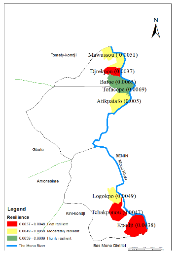
Map 5: Flood resilience map
of the study area
4. Composite vulnerability index of
components
The values of the indicators were used in the following general
equation of vulnerability to determine the overall flood vulnerability index.
Among the eight villages surveyed, Djrekpon and Kpodji are found to experience
relatively high vulnerability with indices ranging from (0.0048-0.0225) ,
Batoe, Atikpatafo, Logokpo and Tchakponou are found to be moderately vulnerable
with indices ranging from (0.0256-0.461) and Mawussou and Tofacope are
estimated to suffer relatively low level of vulnerability to flood disaster
with indices ranging from (0.462-0.668) "Map 6".
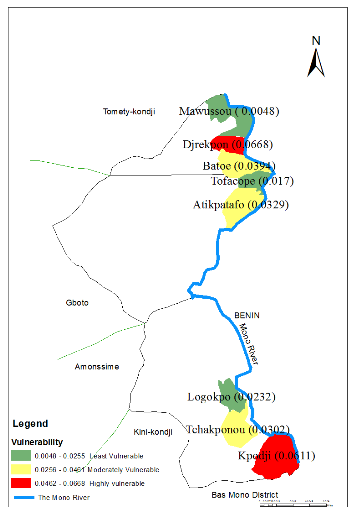
Map 6 Flood vulnerability
map of the study area
This section compares the vulnerability of the selected villages
by computing the composite vulnerability index of the three factors of
vulnerability, using indicators identified under the different determinants of
Human-Environment system and the overall flood vulnerability index. The overall
FVI has shown two most vulnerable villages: Djrekpon and Kpodji. It is found
that Djrekpon and Kpodji villages were highly exposed, Djrekpon was highly
susceptible and Kpodji was moderately susceptible while the two villages were
found to be least resilient. Some justification can be found in these results
by looking at the number of households affected by floods during the last ten
years, the high percentage of household heads with no education level, the lack
of livelihood strategies option of those households, the highly susceptible
building materials, the lack of adequate coping capacity and recovery capacity
from floods. However, the low values found in the different results of the
three factors of flood vulnerability as well as in the overall vulnerability
index for some villages can be misinterpreted as not being vulnerable to
floods. This may not be the case since all determinants of human-environment or
socio-ecological system can be damaged under certain conditions.
| 

