2 STUDY ZONE PHYSICAL ASPECTS
2.1 Geology Elements
The geographical framework crossed by the Zio river comprises
two great geological formations, base terrazzo-gneissic of Precambrian upstream
and coastal tertiary sedimentary basin (Fig. 1) downstream:
- Base terrazzo-gneissic, from Kpédji
to Mission-Tové, on approximately 25 km, the river runs on a crystalline
structure of hard stones constituted of, Micro-diorites quartzes; Compound
gneisses to biotites; fine gneiss to biotites and leptynites; Rawboned gneisses
to quartzes beds; Orthogenesis anatectic to biotites, amphiboles and garnet;
- Basin sedimentary, according to Coque
(1977), is a structural unit morphology corresponding synergies of platforms
covered by sediments following prolonged subsidence. In South-Togo, structure
is characterized by the same slope and direction NNW-SSE, a vast plate
sedimentary which layers constituted by three formations of ages located
between Cretaceous and the Eocene laid in discordance on the Precambrian base
(JOHNSON, 1987).
The sedimentary sequence, from bottom to the top, presents
marine origin, «Continental Terminal» and quaternary formations:
· Marine formations, geology former work research
proved the presence of the:
- Maastrichtien, resting in discordance on the
base and constituted of sands at the base surmounted of sandy then after the
black clay limestone;
- Paleocene, represented by lower sands and
limestone of Togocyamus seefriedi of Tabligbo above which rest a glauconitic
layer;
- Eocene, primarily made up in its half lower
of clays laminated than Palygorskite (attapulgite) and in its higher part of
limestone layers, argillaceous and phosphate layers.
· «Continental Terminal» and quaternary
formations:
- Continental Terminal, qualified higher
diacriticals series (JOHNSON, 1987), rests in discordance with an erosive base
on the marine series and constitutes of diacriticals deposits, sands, clays and
gravels. According to SLANSKY (1962), the Continental Terminal is developed
very little with the Zio basin level;
- Holocene, constitute essential of the
sedimentary material currently drained by the river. On 40 km, from
Gatigblé to Dévégo, more and more silt, Zio runs in owns
formations made of clays and sands then on 10 kilometers, erodes the marine
origin formations described of internal inshore bar or ``yellow sands" (BLIVI,
1993).
These geological and sedimentary formations constitute the
source of sediments transported by Zio river. Their supply is in connection
with the hardness of the bed rock and the mechanical or physicochemical erosion
effect.
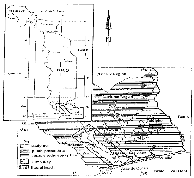
Figure 1: Study area chart: localization and geology
2.2 Climate elements
- Temperature, Zio basin is characterized by
high and constant temperatures with an annual average of 26°C. Low annual
average amplitude thermal does not exceed 40°C. Table (1) has the monthly
average temperatures of Mission-Tové and Lome-airport over 25 years
period.
Table 1: Average monthly of the temperatures from 1980 to
2005
Months
|
|
|
|
|
|
|
|
|
|
|
|
|
Stations
|
J
|
F
|
M
|
A
|
M
|
J
|
J
|
A
|
S
|
O
|
N
|
D
|
Lomé-aéroport
|
27,1
|
27,8
|
28,1
|
28
|
26,8
|
25,5
|
25,4
|
25,5
|
26,1
|
27,8
|
27,1
|
27,2
|
Missio-Tové
|
27,4
|
28,6
|
28,6
|
28,1
|
26,8
|
26,3
|
25,5
|
25,6
|
25,6
|
26,6
|
27,5
|
28
|
|
Source: Météorologie Nationale -
Lomé
Graphic interpretation (Fig. 2) of the data shows that the
duration of the strong temperatures during year on the basin is long (8 months)
and would intervene in the river functionally.
J F M A M J J A S O N D
Months
Lomé-aéroport Mission-Tové
Figure 2: Curves of the monthly average temperatures of the basin
over 25 years
- Rain, the area has two rainy and dry
seasons; annual average total is 1000 mm lower than high basin (1500 mm).
Average monthly magazines recorded during 30 last years are constant (tab
2).
Table 2: Monthly averages of precipitations of 1975 to 2005
Month Stations
|
J
|
F
|
M
|
A
|
M
|
J
|
J
|
A
|
S
|
O
|
N
|
D
|
Lomé-aérot
|
15,17
|
26,35
|
88,43
|
120,1
|
151,83
|
182,56
|
93,25
|
44,18
|
117,24
|
128,2
|
66,94
|
20,15
|
Agoénynivé
|
16,52
|
30,25
|
60,25
|
91,64
|
140,51
|
216,29
|
81,19
|
24,55
|
40,47
|
92,34
|
33,23
|
11,95
|
Togblékopé
|
10,55
|
39,67
|
68,70
|
123,10
|
126,10
|
232,08
|
103,13
|
38,30
|
61,66
|
53,73
|
20,99
|
9,17
|
Mission-T
|
16,67
|
33,17
|
72,10
|
104,32
|
146,22
|
275,74
|
100,02
|
27,12
|
45,84
|
93,15
|
24,98
|
10,41
|
|
Source: Météorologie Nationale -
Lomé
Rainfall graphs (Fig. 3) take a bimodal form with two peaks
located in June and October for the 4 stations. They indicated that the dry
seasons extend on 6 to 7 months and the quantities of recorded rains lowers
upstream and downstream.
Lomé-aéroport Agoènyivé
Togblékopé Mission Tové
300
P
R E C I P I
T A T I O N
S
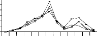
250
200

150

100
50
0
J F M A M J J A S O N D
Months
Figure 3: Rainfall graphs of the monthly averages of the basin
over 30 years
Other elements of the climate which also play a part in the
basin function are the sunstroke, evaporation and humidity.
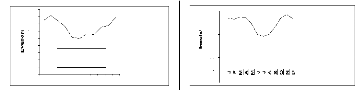
- Sunstroke, South-Togo area receives 4 months
of too strong sun during the dry seasons (December to March) the minima are
recorded during July, June and August (Fig. 4);
- Evaporation, directly related on the
temperature and the sunstroke, his maximum is recorded during in dry
seasons.
Table 3: Monthly averages of the sunstroke from 1980 to 2005
Months
|
|
|
|
|
|
|
|
|
|
|
|
|
Station
|
J
|
F
|
M
|
A
|
M
|
J
|
J
|
A
|
S
|
O
|
N
|
D
|
Lomé-
|
220,1
|
215,6
|
225,3
|
223,5
|
195,4
|
150,1
|
141,7
|
149,2
|
180,8
|
220,2
|
235,7
|
218,9
|
aéroport
|
85,25
|
75,15
|
81,75
|
74,60
|
66,23
|
51,50
|
49,60
|
56,40
|
55,10
|
65,35
|
67,80
|
78,65
|
|
Source: Météorologie Nationale -
Lomé
90
80
70
60
50
40
Lomé- aéroport
85,25
F M A M J J A S O N D
M ois
30
20
10
0
Lomé-aéroport
Mois
250
200
150
100
50
0
Figure 4: Curves of evolution of the monthly averages of
sunstroke and evaporation in the basin
- Relative Humidity, average reaches 80%
mornings; Harmattan, cold wind from the North- East accentuates the moisture
effect; the maximum going up to 90% during January and December.
Months of strong temperatures and sunstroke call a high
evaporation, during which a great volume of water escapes from the soil
exposing the basin very little vegetation covered to a hydrous deficit. The
water level in dropping, the river deposits his load.
|
|


