Zio valley evolution in coastal sedimentary basin finds well
its explanation in river water dynamics, climatic and morphogenetic phases
during geological eras. Thus, according to SLANSKY (1962) quoted by GNONGBO
(1989), stranding or embankment of river bed would be due to a raising of the
basic level subjacent with sedimentary basin which is carried out in liaison
with the tropical Africa landscapes in the north of equator. This support
glacis system establishment and staged terraces. The sedimentary material in
valley would have undergone deep revising afterwards the climate modifications
which have taken place with origin dense forest disappearance to the profit of
savanna, a vegetable cover sparse.
Without to draw outside the thesis which SLANSKY supports,
the present study wants to highlight deforestation and human activities as
causes of river silting up in an short interval time, from independences period
to nowadays or 50 years duration; reference period of the demographic boom and
migrations arable lands investigations towards the wetlands in under area where
the living conditions are favorable to the human settle. It is in this context
that the river basins of sedimentary coastal of Togo knew a population
increasing in record time.
The recorded demographic data of the river basins during the
targeted period show indeed that the densities of populations knew an evolution
out of arrow with the average of 150 inhabitants per km2. Zio river
basin, offering an environment ecologically favorable to the activities of
forestry development, agricultural and artisan, shelters the strong densities
exceeding 300 inhabitants /km2 sometimes. From the 1980s, the
bordering populations to solve the problem of insufficiency of grounds extend
spaces to be cleared on the forest surfaces including the galleries up
difficulty protected by the State.
Incomes of agricultural outputs becoming increasingly weak,
the perverse effects of the economic crisis and the insufficiency of the
intervention by means lack of the public authorities in basin management
supported the abuse use of the forest resources main natural protective of the
grounds against any erosion form.
The topographic sketches carried out (fig.12), starting from
the cartographic and aerial photo data recorded in the 1 960s within the
framework of geological work of basin prospecting by the NGI (National
Geographical Institute - France) and adjusted in 1979 show the various levels
of the river bed flow.
Although there are not other work of raised in the coastal
sedimentary basin being able to
justify with exactitude the zio silting
phenomenon, it is currently noted, that some of these
levels in the zones of thorough deforestation evolved or
moved in trend of it embankment and that is in party due a large volume of
colluviums sediments contribution. Measurements of unevenness of the thalweg
(ADDRA, Topographer/ODEF) within the framework of this study showed compared to
the data of 1979 a difference of coast varying from 0, 7 to 5 m (Fig. 12).
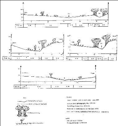
Figure 12: Zio basin topographic sketches indicating the
silting up level
Thus, while taking as reference the river along the
Classified Forest of Eto where the basin is covered with sufficient vegetation
and galleries forests, banks are little degraded, slopes ranging between 0,50
and 2%, Zio is perennial flowing, average coast value is lower to 1 m
indicating the silting up unimportant or marked very little in this zone.
Fields of farm and forest use where banks are almost not
protected, slopes lower than 0,50%, water flow temporary or seasonal, coast of
thalweg raising be from 2 to 3 m corresponding at a stage of advanced fill.
Values from 4 to 5 m are those population area establish, wide market-gardening
activities where the river bed merges almost with alluvial plain floor with
absence of banks, final phase of course water silting up process.


