|

CIPSEM - Centre for International Postgraduate Studies in
Environmental Management
30th INTERNATIONAL POSTGRADUATE COURSE ON
ENVIRONMENTAL MANAGEMENT FOR DEVELOPING AND EMERGING COUNTRIES
FINAL PAPER
|
TITLE:
|
SILTING OF TOGO INSHORE SEDIMENTARY BASIN RIVERS AND
PROTECTION MEASURES: CASE OF ZIO RIVER
|
|
AUTHOR:
|
Mr. AKINTOLA S. NELSON AKIBODE
|
|
COUNTRY:
|
TOGO
|
|
SUPERVISOR:
|
Prof. K. H FEGER
|
|
DATE:
|
JULY 2007
|

ABSTRACT
The main courses water of Togo inshore sedimentary basin are
in silting up and drying. This situation of environmental degradation which
worry or concern for since long time the Ministry of Environment and Forestry
Resources. Despite protection measures used today, rivers degradation is not
stopping.
In this executive training entitled «30th UNEP/UNESCO/BMU
International Postgraduate Course on Environmental Management for Developing
and Emerging Countries» which take place in Dresden (Germany) of the 15
January to 15 July 2007, to improve ours knowledge and experiences in matter of
basin and river protection against erosion, Zio river affected too by the
silting up phenomenon does be the subject of the present study in final paper
as topic: «Silting of Togo inshore sedimentary basin rivers and
protection measures: case of Zio river».
Zio river, length of 178 km, takes his source in the Mounts of
Togo, drains two main geology surfaces, gneiss granite upstream and down-stream
inshore sedimentary basin where it is makes meanders before throwing in the
«Lac-Togo» that communicates with Atlantic Ocean by a pass in
Aného. In the inshore sedimentary basin, the river spreads on 80 km and
his valley covered roughly 400 000 ha. Under the subequatorial climate
characterized by weakness and irregularity rain, the course water after
mountain forest crossing savanna vegetation on ferralitic soils.
Developing vast area of lumbering and agricultural in the
past, Zio basin provides to the riverside residents and urban populations
important natural resources notably earths, wood, fish, pastoral, hunt,
medicinal plants, sediments, and water that constitutes for the first the basis
of subsistence and wealth and for the second a supplies source within research
of hands in woods energy and derivative.
Currently, facing a riverside resident pressure (population
increasing), study area knows a serious deterioration problem of these natural
resources and his environment. River basin degradation is expressed by the drop
of yield agriculture income activities. In fact, silting up or embankment found
his origin in the fore stry destroying and the soils erosion which bring in
river bed the sand and other charges.
Present study gets out the basin environmental degradation
assessment and proposes the standard models to protect and restore the river
banks against the silting up or erosion. It is recommended about conducting a
participating and lasting forest reforestation of the basin, the agro forestry
promote, bush fires managing, biodiversity protect, river users awareness, and
practicing the anti-erosive measures. New technical measures of environmental
protection implemented will be braking or reducing erosion speed in the basin
and improving as well the riverside resident's life conditions.
ACKNOWLEDGEMENTS
Since we were allowed with the Ministry of the Environment and
Forestry Resource, precisely in Office of Water and Forestry, our major
concerns is desertification phenomenon one of main causes of Togo rivers
silting up.
In fact, profit-sharing environmental problems was born from
the orientation of our university course which we buckled for obtaining the
diploma of ?Maitrise-es-Lettres" geography physical option by define on the
topic ?Contribution to the hydro-geomorphologic study of the Zio low valley ".
It should be noted that ground work for memory drafting and our regular
presence in the valley which more drew our attention on the river silting
up.
With aim of look further into the problems and to draw
attention of the ministries developing decision makers and other basin managers
on his degradation, that for this professional advanced training course
registered during ?International Training one Program Environmental Management
for Developing and Emerging Countries", we are targeted again the same area
study through the topic entitled ? Silting up of Togo Inshore Sedimentary Basin
Rivers and Protection Measures: case of the Zio river".
The study proposes to give a report on the places, to examine
the mechanism of river silting up in order to put forward concrete measures
having to contribute to stabilize, protect the banks and to fight effectively
against defore station and desertification.
At the time of having results of this study, I would like to
express my very sincere recognition and my thanks for all institutions and
people who worked materially and morally for the happy result of this final
paper; for this purpose, my thanks go to:
- Institutions which granted this purse of
training course and to organize this vocational training, I quote, United
Nations for Environment Program (UNEP); United Nations for Science and Culture
Organization (UNESCO); Germany Federal Ministry for the Environment, Natural
Conservation, and Nuclear Safety; Centre for International Postgraduate Studies
of Environmental Management (CIPSEM)- TUD in Dresden/Germany;
- Togo Government authorities in particular
those of Ministry of Environment and Forestry Resource, which in the permanent
concern human resources capacity reinforce does not spare any effort to
maintain within this framework a profitable policy international
co-operation;
- Dr. - Ing. Rolf Baur, Head or Course
Director, for all its efforts authorized for the good walk of academic
activities to the Center for International Postgraduate Studies of
Environmental Management;
- My supervisor, Prof. K.H. Feger which over
his lectures accepts to follow me in my final paper writing and gives me the
best protection aptitudes as regarding erosion of sedimentary basin soils and
rivers;
- All staffs of Secretariat Course (CIPSEM)
and colleagues of promotion with I quickly familiarized itself during my German
enjoy;
- My love Youlmane who supports me in my
moods without I could not taken this step in my career; I share with you the
paternity of this diploma sanctioning the end of this training;
- Nicodème and Mazarine, like the
ploughman and these children of FABLE, I highly recommend you to work without
respite because only the careful work is the man liberator.
TABLE OF CONTENTS
ABSTRACT i
ACKNOWLEDGEMENTS ii
1 INTRODUCTION 1
2 STUDY ZONE PHYSICAL ASPECTS 2
2.1 Geology Elements 2
2.2 Climate elements 3
2.3 Soils and Vegetation 5
2.3.1 Types of soils 5
2.3.2 Vegetation 5
2.4 Zio Hydrological characteristics 5
2.4.1 Hydrographic network and catchments area 6
2.4.2 Zio Hydrological assessment 9
2.5 Zio valley morphology 10
2.5.1 Zio basin plates 10
2.5.2 Inshore bars zone 10
2.5.3 Zio river sediment terraces 10
2.5.4 Zio low alluvial plain: flooding zone 11
3 MECANISM OF RIVER SILTING UP 12
3.1 Types of basin erosion 12
3.1.1 Splash and waters extract 12
3.1.2 Stream 13
3.1.3 Rain erosion and river erosion 13
3.2 Zio river silting 13
4 HUMAN ACTIONS FACTORS OF ZIO RIVER SILTING UP AND BASIN
DEGRADATION 15
4.1 Deforestation 16
4.2 Pollution 16
4.3 Uncontrolled occupation and socio-economic activities
18
4.4 Impacts of human action 18
5 SOLUTION APPROACHES OF RIVER SILTING UP AND BASIN
DEGRADATION 19
5.1 Basin reforestation and fire management 20
5.2 Biodiversity protection 21
5.3 Fight against eutrophication 22
5.4 Bordering populations awareness 22
5.5 Anti-erosive measurements and soil erosion control 23
6 CONCLUSION AND RECOMMENDATIONS 24
REFERENCES 25
1 INTRODUCTION
Togo coastal sedimentary basin, of passive margin, is integral
part of West Africa sedimentary unit extending from Ghana to Nigeria; it is
presented as a plate dissected by a hydrographic network which belong Zio river
is the subject of this study. Located between 6°11' to 6°32' LN and
1°01' to 1°29' LE, study zone extends on 80 km from Kpédji to
Agbodrafo and roughly covers a surface of 400.000 ha. It is under the
subequatorial climate influency characterized by weakness precipitations. Also
it shelters savanna vegetation raised on ground with ferrallitic
predominance.
Like Mono and Haho, Zio river, main course water of
South-Togo, has a 178 km length, takes his source in Togo Mountain, drains the
plain terrazzo-gneissic upstream and coastal sedimentary basin downstream where
it carries out meanders before being thrown in lake (Lac-Togo) which
communicates with the Atlantic Ocean by an pass in Aného. Developing
forest extents and farm in past, the zone provides for bordering and urban
populations surround important natural resources: food products, wood, water,
and pastoral resources.
Face of the resident's demographic pressure and its
surroundings, the target area knows serious degradation problems, natural
resources and its environment which is means in erosion term by the silting and
river bed progressive drying due to the massive forest destroying. To solve
these environment problems and for a greater comfort of the bordering
populations and other recipients, it is important to arrange it suitably. This
project requires a good knowledge on the zone and preliminary studies, step
essential for any attempt to durable human development. It is accordingly that
we propose in this final paper as regards management environmental to
contribute our modest share.
Study zone profited from former studies on pedo-hydrology
(ORSTOM, 1967); geomorphology (GNONGBO, 1989); impact of the climate on the
river catchments area evolution (KLASSOU, 1989); hydro-geomorphology (AKIBODE,
2000). But in a specific way, all work studies truly did not develop river
silting up topic then make proposals fight measures.
To take up the challenge, study proceeds evaluation of the
area degradation and proposes standard models foresters and rivers measure
protection to stabilize, protect, restore these banks against silting up and to
fight effectively deforestation and erosion. Results of analysis and
interpretation of documentation, information collected and field work for
observations and checking allowed dividing plan of this document in four
chapters:
First entitled, Study Zone Physical Aspects which bring
information on, Geology Elements, Bioclimatic Environment and Basin
Hydro-geomorphologic Characteristics; second, Mechanism of Zio River Silting;
third, Human Factors of Zio River Silting and Basin Degradation and fourth,
Solution Approaches.
2 STUDY ZONE PHYSICAL ASPECTS
2.1 Geology Elements
The geographical framework crossed by the Zio river comprises
two great geological formations, base terrazzo-gneissic of Precambrian upstream
and coastal tertiary sedimentary basin (Fig. 1) downstream:
- Base terrazzo-gneissic, from Kpédji
to Mission-Tové, on approximately 25 km, the river runs on a crystalline
structure of hard stones constituted of, Micro-diorites quartzes; Compound
gneisses to biotites; fine gneiss to biotites and leptynites; Rawboned gneisses
to quartzes beds; Orthogenesis anatectic to biotites, amphiboles and garnet;
- Basin sedimentary, according to Coque
(1977), is a structural unit morphology corresponding synergies of platforms
covered by sediments following prolonged subsidence. In South-Togo, structure
is characterized by the same slope and direction NNW-SSE, a vast plate
sedimentary which layers constituted by three formations of ages located
between Cretaceous and the Eocene laid in discordance on the Precambrian base
(JOHNSON, 1987).
The sedimentary sequence, from bottom to the top, presents
marine origin, «Continental Terminal» and quaternary formations:
· Marine formations, geology former work research
proved the presence of the:
- Maastrichtien, resting in discordance on the
base and constituted of sands at the base surmounted of sandy then after the
black clay limestone;
- Paleocene, represented by lower sands and
limestone of Togocyamus seefriedi of Tabligbo above which rest a glauconitic
layer;
- Eocene, primarily made up in its half lower
of clays laminated than Palygorskite (attapulgite) and in its higher part of
limestone layers, argillaceous and phosphate layers.
· «Continental Terminal» and quaternary
formations:
- Continental Terminal, qualified higher
diacriticals series (JOHNSON, 1987), rests in discordance with an erosive base
on the marine series and constitutes of diacriticals deposits, sands, clays and
gravels. According to SLANSKY (1962), the Continental Terminal is developed
very little with the Zio basin level;
- Holocene, constitute essential of the
sedimentary material currently drained by the river. On 40 km, from
Gatigblé to Dévégo, more and more silt, Zio runs in owns
formations made of clays and sands then on 10 kilometers, erodes the marine
origin formations described of internal inshore bar or ``yellow sands" (BLIVI,
1993).
These geological and sedimentary formations constitute the
source of sediments transported by Zio river. Their supply is in connection
with the hardness of the bed rock and the mechanical or physicochemical erosion
effect.
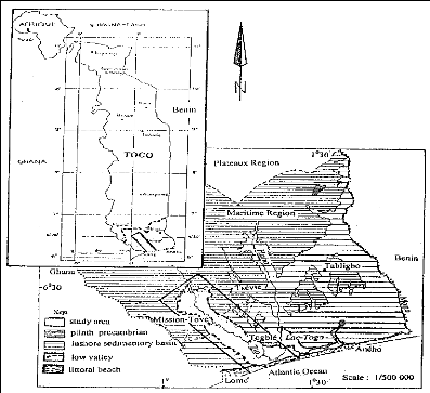
Figure 1: Study area chart: localization and geology
2.2 Climate elements
- Temperature, Zio basin is characterized by
high and constant temperatures with an annual average of 26°C. Low annual
average amplitude thermal does not exceed 40°C. Table (1) has the monthly
average temperatures of Mission-Tové and Lome-airport over 25 years
period.
Table 1: Average monthly of the temperatures from 1980 to
2005
Months
|
|
|
|
|
|
|
|
|
|
|
|
|
Stations
|
J
|
F
|
M
|
A
|
M
|
J
|
J
|
A
|
S
|
O
|
N
|
D
|
Lomé-aéroport
|
27,1
|
27,8
|
28,1
|
28
|
26,8
|
25,5
|
25,4
|
25,5
|
26,1
|
27,8
|
27,1
|
27,2
|
Missio-Tové
|
27,4
|
28,6
|
28,6
|
28,1
|
26,8
|
26,3
|
25,5
|
25,6
|
25,6
|
26,6
|
27,5
|
28
|
|
Source: Météorologie Nationale -
Lomé
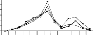
Graphic interpretation (Fig. 2) of the data shows that the
duration of the strong temperatures during year on the basin is long (8 months)
and would intervene in the river functionally.
J F M A M J J A S O N D
Months
Lomé-aéroport Mission-Tové
Figure 2: Curves of the monthly average temperatures of the basin
over 25 years
- Rain, the area has two rainy and dry
seasons; annual average total is 1000 mm lower than high basin (1500 mm).
Average monthly magazines recorded during 30 last years are constant (tab
2).
Table 2: Monthly averages of precipitations of 1975 to 2005
Month Stations
|
J
|
F
|
M
|
A
|
M
|
J
|
J
|
A
|
S
|
O
|
N
|
D
|
Lomé-aérot
|
15,17
|
26,35
|
88,43
|
120,1
|
151,83
|
182,56
|
93,25
|
44,18
|
117,24
|
128,2
|
66,94
|
20,15
|
Agoénynivé
|
16,52
|
30,25
|
60,25
|
91,64
|
140,51
|
216,29
|
81,19
|
24,55
|
40,47
|
92,34
|
33,23
|
11,95
|
Togblékopé
|
10,55
|
39,67
|
68,70
|
123,10
|
126,10
|
232,08
|
103,13
|
38,30
|
61,66
|
53,73
|
20,99
|
9,17
|
Mission-T
|
16,67
|
33,17
|
72,10
|
104,32
|
146,22
|
275,74
|
100,02
|
27,12
|
45,84
|
93,15
|
24,98
|
10,41
|
|
Source: Météorologie Nationale -
Lomé
Rainfall graphs (Fig. 3) take a bimodal form with two peaks
located in June and October for the 4 stations. They indicated that the dry
seasons extend on 6 to 7 months and the quantities of recorded rains lowers
upstream and downstream.
Lomé-aéroport Agoènyivé
Togblékopé Mission Tové
300
P
R E C I P I
T A T I O N
S
250
200

150

100
50
0
J F M A M J J A S O N D
Months
Figure 3: Rainfall graphs of the monthly averages of the basin
over 30 years
Other elements of the climate which also play a part in the
basin function are the sunstroke, evaporation and humidity.
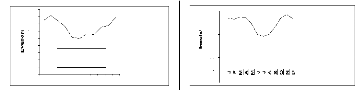
- Sunstroke, South-Togo area receives 4 months
of too strong sun during the dry seasons (December to March) the minima are
recorded during July, June and August (Fig. 4);
- Evaporation, directly related on the
temperature and the sunstroke, his maximum is recorded during in dry
seasons.
Table 3: Monthly averages of the sunstroke from 1980 to 2005
Months
|
|
|
|
|
|
|
|
|
|
|
|
|
Station
|
J
|
F
|
M
|
A
|
M
|
J
|
J
|
A
|
S
|
O
|
N
|
D
|
Lomé-
|
220,1
|
215,6
|
225,3
|
223,5
|
195,4
|
150,1
|
141,7
|
149,2
|
180,8
|
220,2
|
235,7
|
218,9
|
aéroport
|
85,25
|
75,15
|
81,75
|
74,60
|
66,23
|
51,50
|
49,60
|
56,40
|
55,10
|
65,35
|
67,80
|
78,65
|
|
Source: Météorologie Nationale -
Lomé
90
80
70
60
50
40
Lomé- aéroport
85,25
F M A M J J A S O N D
M ois
30
20
10
0
Lomé-aéroport
Mois
250
200
150
100
50
0
Figure 4: Curves of evolution of the monthly averages of
sunstroke and evaporation in the basin
- Relative Humidity, average reaches 80%
mornings; Harmattan, cold wind from the North- East accentuates the moisture
effect; the maximum going up to 90% during January and December.
Months of strong temperatures and sunstroke call a high
evaporation, during which a great volume of water escapes from the soil
exposing the basin very little vegetation covered to a hydrous deficit. The
water level in dropping, the river deposits his load.
2.3 Soils and Vegetation
The zone covers three types of grounds on the Maritime Area
soil chart (ORSTOM, 1967; Institute National des Soils, 1987); there are
ferralitic soils, hydromorphic or not and the vertisoils. Their genesis would
be closely related on topography, climate, and vegetation factors.
2.3.1 Types of soils
- Ferralitic soils, characterized by the
prevalence of the iron oxidation actions and sand argillaceous texture; they
are red and thick soils from 10 to 15 m; they are widest in the zone;
- Hydromorphic soils, located along the river
in a discontinuous way, in the depressions and mouth; muddy clay texture to
sand spreader, they are identified by the red beige color;
- Non-hydromorphic soils, little extended,
they are made of a fine colluvium's from 30 to 70 cm thickness, found in edge
of the plates, and presented in the form of micro-reliefs slightly
corrugated;
- Vertisols, located in the depressions and the
mouth, they are constituted of clays inflating very permeable with water.
According to the agriculture soils study carried out by the
National Institute of the Soils (INS, 1987), these grounds are very permeable
and eroded easily when they are without vegetation.
2.3.2 Vegetation
Study zone shows two vegetable formations, flood zones and
non-flood zones vegetation:
- Flood zones vegetation, it is an
herbaceous vegetable formation with some ligneous which the height does not
exceed 10 m. Theses ligneous are Ceiba pentendra, Uapaca
heudeti, Cola gigantea; the sand banks in the minor bed carry
hygrophilous species like Cyperaceae, tufts of bushes
made up of Mimosa pigra and Phyllantus
reticulatus;
- Non-flood zones vegetation, extending in the
plates and slopes; they are the formations: . Arborescent
higher, 15 m in height populated of Adansonia digitata and
Vitex doniana;
. Arborescent lower and shrubby, composed of
Guinean savannas species with Vitellaria paradoxa and
Terminalia glauxesens;
. Herbaceous, not exceed 2 m height and
dominated by Andropogon gayanus and Panicum
maximum.
These bioclimatic facts justify the savanna field extension
in the sedimentary basin whose complex soil-vegetation is influenced by the
climatic mode and Zio hydrological characteristics.
2.4 Zio Hydrological characteristics
Zio river, with its arms Edin in Togblé and Adougba in
Tonoukouti, shows a small dense hydrographic network in the coastal sedimentary
basin.
2.4.1 Hydrographic network and catchments area
- Hydrographic network, Zio river, inside
type belongs to the hydrographic system of the South-Togo has North-South
direction. The basin develops an alluvial plain in the shape of funnel which is
spread out towards the mouth characteristic of the silting phenomenon.
Depending of the sedimentary structure, Zio valley little boxing shows very
weak unevenness of gradients which values ranging between 0, 5 and 2%;
- Zio catchments area, with these effluents,
the river runs in a mixed area catchments crystalline structure separated
upstream from the sedimentary basin by a change of incline altitudinal to the
latitude in Mission-Tové. From the supply point of view water of the
bed, Zio collects its water according to the diagram hereafter:

Evapotranspiration
(Vegetation)
River bed (talweg)
Groundwater
Rain
Stream
Infiltrations
Hydro-
network
Figure 5: Water supply of the Zio river
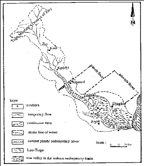
Figure 6: Zio catchment area and hydrographic network
- Rain mode, the data of table (4) show the
rate/rhythm of evolution of annual average rainy in the area catchments of the
South to North; the annual cycle of precipitations in the various stations
appears irregular.
2500
2000
1500
1000
500
0
1 4 7 10 13 16 19
Assanhoun Mission Togblékopé
2500
2000
1500
1000
500
0
1 3 5 7 9 11 13 15 17 19
Anné e s
Adéta Kati Kpédji
Figure 7: Curves of evolution of annual average precipitations
over 20 years
Over 20 years' period, it is notes that the catchments area
records the strong and weak rains. This variation of the fallen quantities of
water explains also the behavior of hydrological flows of Zio.
Table 4: Annual averages rain stations of the Zio catchments
area (in mm)
|
High valley
|
Low valley
|
Stations years
|
Adéta
|
Kati
|
Kpédji
|
Assanhoun
|
Mission-T
|
Togblékopé
|
1980
|
1415,1
|
1395,5
|
1323,4
|
1678,7
|
1079,4
|
1276,5
|
1981
|
1484,0
|
1462,8
|
1138,5
|
1905,4
|
1109,7
|
1237,0
|
1982
|
1979,7
|
2037,4
|
1570,2
|
1789,6
|
1450,6
|
1800,9
|
1983
|
1443,0
|
1450,6
|
1126,5
|
1125,4
|
0818,3
|
1175,2
|
1984
|
1359,3
|
1397,5
|
0730,8
|
1022,3
|
0800,0
|
1148,8
|
1985
|
1262,9
|
1367,4
|
0950,3
|
0949,2
|
0958,1
|
1190,2
|
1986
|
1027,4
|
1217,6
|
1031,8
|
1218,8
|
0907,9
|
1133,7
|
1987
|
1385,5
|
1418,9
|
1150,0
|
1040,1
|
1039,8
|
1201,0
|
1988
|
1577,0
|
1375,8
|
1146,6
|
1034,9
|
1081,6
|
1257,4
|
1989
|
1588,0
|
1531,0
|
1201,1
|
1103,2
|
0984,8
|
1293,2
|
1990
|
1273,6
|
1234,3
|
0971,7
|
0935,6
|
0646,8
|
0996,4
|
1991
|
1362,3
|
1048,1
|
0782,1
|
0650,1
|
0613,7
|
0978,3
|
1992
|
1451,1
|
1527,2
|
1149,1
|
0924,2
|
0798,5
|
1206,8
|
1993
|
1596,0
|
1689,0
|
1184,0
|
1205,7
|
1024,5
|
1341,3
|
1994
|
1701,2
|
1674,2
|
1351,7
|
1171,1
|
0945,4
|
1414,2
|
1995
|
1446,7
|
1463,1
|
0832,8
|
0903,3
|
0840,3
|
1089,5
|
1996
|
1118,3
|
1357,2
|
0863,6
|
1097,7
|
0830,1
|
1113,4
|
1997
|
1327,0
|
1440,6
|
0995,0
|
0762,0
|
0805,8
|
0963,9
|
1998
|
1346,3
|
1508,1
|
1126,5
|
1051,2
|
0856,9
|
1460,5
|
1999
|
1322,6
|
1596,9
|
1319,0
|
1192,1
|
0697,5
|
1319,7
|
|
Source: Météorologie Nationale -
Lomé
- Zio hydrological mode, it is characterized
by the succession high and low waters periods. The high waters correspond the
rains seasons while low waters coincide with the dry seasons. It is rises from
this water periodic distribution, the seasonal variations of the flow gives of
the river a subequatorial functionally mode.
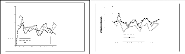
Analysis curves (fig.8) of interannual average monthly Zio
flows with Kati, Kpédji and Togblé make it possible to identify
and to know its hydrological characters: increase and low water level.
. Season of swell waters and floods, the
period of high waters is approximately 5 months with two maximum. It goes from
July to November; the first maximum is recorded towards the end of July where
the height of water is important and causes the great rising; the flow
overflows the average bed and occupies the major bed on several meters; it is
the period of strong flows; the erosive action of water is accelerated. The
second maximum is between September and October with relatively low heights of
water;
. Season of low waters, it is spread out over
6 to 7 months, from December to May or June; the period of low waters is copied
almost on that of the great dry season. The minor bed undergoes a low water
level or a draining which is accentuated during February, January and March.
It comes out from these observations that the Zio
hydrological mode is seasonal and characterized by one high waters period in
July and low waters in January. There is thus a similarity between the climatic
seasonal mode of the sector and the behavior of river hydrological flows. The
basin is thus subjected to a subequatorial rainy mode with the rather irregular
seasonal characteristics justifying the interannual variability flow.
- Interannual variability of Zio flow, flow
values (tabl.5) of Zio over the period considered, show that the flow knows
hydrologic variations which related to the rate/rhythm of rain; the high flows
correspond to years of strong rains.
Table 5: Zio annual average flows on 21 years (in
m3)
Stations
years
|
Kati
|
Kpédji
|
Togblé
|
1980
|
4,48
|
7,26
|
9,26
|
1981
|
4,98
|
9,43
|
9,35
|
1982
|
8,11
|
24,10
|
18,88
|
1983
|
4,82
|
8,52
|
6,35
|
1984
|
4,49
|
3,47
|
5,83
|
1985
|
4,42
|
7,37
|
6,65
|
1986
|
3,12
|
4,49
|
5,68
|
1987
|
4,62
|
5,60
|
6,18
|
1988
|
4,31
|
6,58
|
7,96
|
1989
|
5,77
|
8,66
|
9,29
|
1990
|
3,88
|
3,82
|
3,26
|
1991
|
1,82
|
1,91
|
1,40
|
1992
|
4,96
|
4,35
|
4,92
|
1993
|
6,28
|
14,53
|
10,51
|
1994
|
6,19
|
15,36
|
10,55
|
1995
|
4,24
|
6,18
|
7,59
|
1996
|
4,52
|
3,20
|
4,56
|
1997
|
4,72
|
0,40
|
1,06
|
1998
|
4,80
|
10,66
|
12,69
|
1999
|
3,25
|
11,24
|
7,67
|
2000
|
3,20
|
11,36
|
7,75
|
|
Source: Service Hydrologie-Lomé
Curves analysis (fig.8 and 9) concludes that the Zio water
reaction is closely related to the rain mode of the study zone.
2.4.2 Zio Hydrological assessment
Zio takes its source in the dorsal of Atakora whose extension
in latitude prolongs in soudanian zone which records 1500 mm per year,
characteristic of Guinean wet climate. This dorsal thanks to the impermeability
of its substratum schist quartzitic, the river maintains a area flow to 30
m3/s in periods of high waters. Other hand, in the more permeable
sedimentary basin where average rainy is 1000 mm in seasons of strong rains,
the flow is lower than 10 m3/s.
The years of low water level record severe about 1.4
m3/s or sometimes null flows when the year is very dry. This deficit
includes all water losses due to evaporation, evapotranspiration, and
infiltration. The report, ratio flow of flood/minimum flow and the flow
coefficients which are indicators of checking evolution and importance of past
water remain in together weak for the Zio river because clays abundance and
very permeable alluvia. Direct consequence of flow deficit is the small
quantity of the past water blades; table (6) presents the coefficients of Zio
flow over 20 years period.
Total rain amounts explain well the interannual variations of
the flow coefficients. It is thus advisable to specify that the distribution of
rains during year intervenes in the determination of the hydrological mode of
the river whose impacts appear through erosion.
Table 6: Calculated values of the Zio flow coefficients
Flow Coefficients (%)
|
years
|
Kati
|
Kpédji
|
Togblé
|
1980
|
11,1
|
9,2
|
8,8
|
1981
|
11,6
|
11,9
|
9,1
|
1982
|
14,3
|
20,8
|
12,7
|
1983
|
11,5
|
10,9
|
6,6
|
1984
|
11,1
|
4,7
|
6,1
|
1985
|
11,2
|
9,5
|
6,8
|
1986
|
8,9
|
6
|
6
|
1987
|
11,3
|
7,2
|
9,2
|
1988
|
10,8
|
7,9
|
7,7
|
1989
|
13
|
10,1
|
8,8
|
1990
|
10,9
|
5,7
|
4
|
1991
|
6,0
|
2,7
|
2
|
1992
|
11,2
|
5,3
|
5
|
1993
|
12,9
|
16,2
|
9,5
|
1994
|
12,8
|
16,3
|
8,5
|
1995
|
10
|
8,4
|
8,5
|
1996
|
10,4
|
4,4
|
5
|
1997
|
11,7
|
0,6
|
1,3
|
1998
|
10,8
|
12,6
|
10,5
|
1999
|
11,1
|
13,1
|
7
|
|
Source: Service Hydrologie-Lomé
|
|
|
|
|
|
|
|
|
|
|
|
|
|
|
|
|
|
|
|
|
|
|
|
|
|
|
|
|
|
15
|
|
|
|
|
Kati
|
|
|
15
|
|
|
|
|
|
|
|
|
|
|
|
|
|
|
|
|
|
|
|
|
|
|
|
|
|
|
|
10
|
|
|
|
|
|
|
10
|
|
|
|
|
|
|
|
|
|
|
|
|
|
|
|
|
|
5
|
|
|
|
|
|
|
|
|
|
5
|
|
|
|
|
|
|
0
|
|
|
|
|
|
|
|
|
|
|
|
|
|
|
|
|
|
|
|
3
|
5
|
7
|
9 1 1 13
|
1 5
|
1 7 19 21
|
|
0
1 3
|
5
|
7
|
91113151719
|
|
|
|
|
|
|
|
An née s
|
|
|
|
|
|
|
|
Année s
|
|
|
Kati
|
|
|
|
Kpédji
|
|
Togblé
|
|
|
|
|
|
|
|
|
|
|
|
|
|
Figure 8:Curves of annual medium flows Figure 9:Curves of
evolution of the flow
Zio river over one 20 years period of Zio over 21 years
2.5 Zio valley morphology
Geomorphology sketch interpretation (fig. 11) carried out
starting from the air photographs of the study area made it possible to
recognize that the morphology of the Zio valley in the sedimentary basin which
is delimited in the West by the plate of Agoènyivé, in the East
by those of Kpogan and Tsévié and in the South by the offshore
bars. These covered geomorphologic units little vegetation are the main
sediments providers of course water.
2.5.1 Zio basin plates
- Agoènyivé plate, extending
approximately on 45 km with average altitude 40 m, is lengthened with the
sinuous edge, delimits right river bank;
- Kpogan and Tsévié plates,
respectively average altitude 30 m and 90 m, they are laid out the first and
are almost parallel to separated by the LAMA depression; they extend
approximately on 50 km with slopes to the convexo-concave pace.
2.5.2 Inshore bars zone
Showing the sea sand cords internal and external primarily
made up at constant sand; they are below laid out plates of soil bar and
average height varying between 4 and 6 m (BLIVI, 1993). Zio drains the offshore
bar interns on 14 km where it is carried out many meanders justifying river
erosive dynamics and the flatness of the valley in the mouth.
2.5.3 Zio river sediment terraces
From the morphological point of view, the alluvial terraces
is a system of projecting ledges or stages below deposited in slopes of valley
by a river. The top of the projecting ledges is covered with sediments
corresponding to the bottom of the river successive beds. The valleys generally
show three kinds of levels at knowing, high, average and low terrace. Also,
these terraces are differenced by their conservation degree, iron oxidation and
hard sedimentary material which compose them.
While basing itself on these criteria of terraces
recognizing, the study zone presents the gravel terraces in Assomé
(GNONGBO, 1989) and those alluvia in Togblékopé (AKIBODE, 2000)
located at about thirty kilometers at the South-east of the first. There is
transition zone with approximately 3 km between these two alluvial formations
where sedimentary material in extraction is a mixture of gravels, clays, and
sands.
A transect from Agoènyivé plate to
Togblékopé shows the space provision of the terraces with alluvia
(fig.10); deposit of these terraces was done in a discontinuous way. This
diagram is almost the same to Dévégo but with two alluvial
terraces levels below the internal offshore bar.
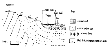
Figure 10: Zio alluvia terraces space provision
2.5.4 Zio low alluvial plain: flooding zone
It is a plain of accumulation of surface corresponding to the
low valley top fill; weak slopes, results from the contributions
plio-quartenary made up of alluvia with clay and sand texture.
Slightly boxed, Zio valley presents unevenness from 1 to 2 m
and slopes ranging between 0,2 to 2%. This topography shows that the low valley
is old silting clogged by alluvia coming from the high basin following the
deterioration of the crystalline rocks (GNONGBO, 1989). It is in these alluvia
that easily flooded zones are extended arms and spreading out river bed.
- Major bed, it is the bed which the river
can cover by current alluvia after flood; furrowed of old axes of drainage and
supplied with colluviums, it extends on average on 1 km and receives water of
exceptional, unforeseeable risings. To up horizontal topography, this bed is
related to the minor by banks of average unevenness 3 m.
- Minor bed, in the shape of ?U`` or in
cradle and broad 10 m on average, this bed presents a slightly tilted flat
bottom in direction of the south. Current channel of Zio flows, its
convexoconcave banks are cut in sandy and clay material. Concave sectors, of
slopes precipice are indication of water strong erosive activity. At the end of
the dry season, the minor bed apparently merges to the bed at low water which
is encumbered many sand banks of dimensions variable and intercalated by
ponds.
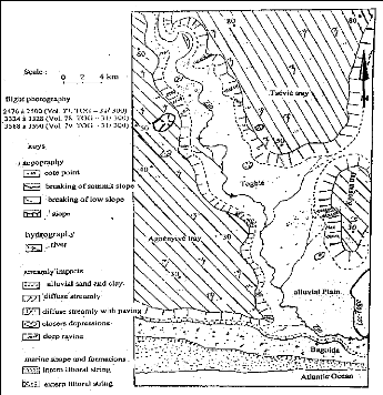
Figure 11: Recognizing geomorphology sketch of Zio valley in
coastal sedimentary basin
(Akibodé, 2000)
3 MECANISM OF RIVER SILTING UP
River water and runoff constitutes the main agents of erosion
and transport in the basin through the processes of splash and stream to work
interfluves, slopes and plains. The human action also contributes to the
environmental degradation in the basin.
3.1 Types of basin erosion
3.1.1 Splash and waters extract
- Splash, more widespread in the culture field
where the grounds are entirely stripped; the rainy in dropping compress the
movable superficial level;
- Water extract, of hydrous origin, it
causes fragmentation by alternations of moistening and desiccation of the
grounds. It affects the materials inflating such as clays which absorb a lot of
water. Also infiltrated water accomplishes a transport of fine particles
in-depth thus creating a vacuum under the horizontally packed ground; this
subsides under the effect of its weight. Racking would be at the origin of the
closed depressions and would have also generated the installation of the
ponds.
3.1.2 Stream
- First stream, it starts at the beginning of
the rain, transports the fine particles in particular the beforehand detached
silts and erodes the ground of a few centimeters;
- Concentrated stream, it is started when
the quantity of rainwater is important on the ground surface which sometimes
sporadic flow. Water incises the ground vertically; on the slopes, the
concentrated stream prints model of drains, the gullies. As indication, the
measures taken in the concave sectors of the slopes starting from the meter
ribbon and a plumb line of the incisions marks in two localities arise as
follows:
Togblékopé Tonoukouti
Modelled
Dimension
Gullies
0,1 à 0,3m
Ravines
1m
Modelled
|
Gullies
|
Ravines
|
Dimension
|
0,1 à 0,3m
|
1,2m
|
|
It is noted that the ravines have abrupt banks and in the
other hand present sometimes a broad bottom at the transverse profile in ?U"
the gullies have a pace in «V». The presence of stiff banks proves
that erosion is carried out in a vertical way. Incised slopes of ravines show
an aspect of «bad-lands».
3.1.3 Rain erosion and river erosion
- Rain erosion, according to TRICART (1977),
it is caused by torrential rains; the water drops while falling in quantity and
at a high speed on the naked ground exert a pressure of potential origin which
involves the detachment of the particles or group particles called
disintegration;
- River erosion, it is summarized of river
water mechanical action which drains its own alluvia and this at the time of
the exceptional risings after the strong rains. These risings of ten days
approximately cause the overflow of water which involves the sweeping of
sediments and remains vegetable of the basin in direction of the Zio bed.
At the end of the risings, the sand banks settle along the
maximum limit reached by high waters; the provision parallel of the sand banks
with the alluvial plain indicates that the risings carried out a lateral
cutting. These sand banks are taken again by surface waters after the rising
period.
The major form of fluviatile erosion is the meander
characterized by curves alternated more or less regularly; in the alluvial
plain, Zio carries out about thirty meanders. Also, in this alluvial plain,
there are two types of depression:
. Depression floods, which drain their water
with the fall; stagnant water almost does not remain, however in certain
depressions the humidity is maintained by the water flasks with a papered
bottom of fine silts;
. Depressions of decantation, closed, from
circular form, they receive water of raw which remains for a long time. Clays
are elutriated, also there are remains organic (died sheets, tree trunks etc)
at the bottom of these depressions.
3.2 Zio river silting
Zio valley evolution in coastal sedimentary basin finds well
its explanation in river water dynamics, climatic and morphogenetic phases
during geological eras. Thus, according to SLANSKY (1962) quoted by GNONGBO
(1989), stranding or embankment of river bed would be due to a raising of the
basic level subjacent with sedimentary basin which is carried out in liaison
with the tropical Africa landscapes in the north of equator. This support
glacis system establishment and staged terraces. The sedimentary material in
valley would have undergone deep revising afterwards the climate modifications
which have taken place with origin dense forest disappearance to the profit of
savanna, a vegetable cover sparse.
Without to draw outside the thesis which SLANSKY supports,
the present study wants to highlight deforestation and human activities as
causes of river silting up in an short interval time, from independences period
to nowadays or 50 years duration; reference period of the demographic boom and
migrations arable lands investigations towards the wetlands in under area where
the living conditions are favorable to the human settle. It is in this context
that the river basins of sedimentary coastal of Togo knew a population
increasing in record time.
The recorded demographic data of the river basins during the
targeted period show indeed that the densities of populations knew an evolution
out of arrow with the average of 150 inhabitants per km2. Zio river
basin, offering an environment ecologically favorable to the activities of
forestry development, agricultural and artisan, shelters the strong densities
exceeding 300 inhabitants /km2 sometimes. From the 1980s, the
bordering populations to solve the problem of insufficiency of grounds extend
spaces to be cleared on the forest surfaces including the galleries up
difficulty protected by the State.
Incomes of agricultural outputs becoming increasingly weak,
the perverse effects of the economic crisis and the insufficiency of the
intervention by means lack of the public authorities in basin management
supported the abuse use of the forest resources main natural protective of the
grounds against any erosion form.
The topographic sketches carried out (fig.12), starting from
the cartographic and aerial photo data recorded in the 1 960s within the
framework of geological work of basin prospecting by the NGI (National
Geographical Institute - France) and adjusted in 1979 show the various levels
of the river bed flow.
Although there are not other work of raised in the coastal
sedimentary basin being able to
justify with exactitude the zio silting
phenomenon, it is currently noted, that some of these
levels in the zones of thorough deforestation evolved or
moved in trend of it embankment and that is in party due a large volume of
colluviums sediments contribution. Measurements of unevenness of the thalweg
(ADDRA, Topographer/ODEF) within the framework of this study showed compared to
the data of 1979 a difference of coast varying from 0, 7 to 5 m (Fig. 12).
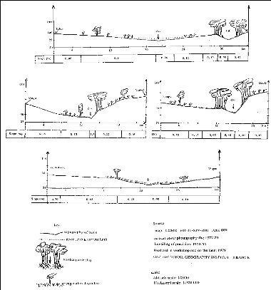
Figure 12: Zio basin topographic sketches indicating the
silting up level
Thus, while taking as reference the river along the
Classified Forest of Eto where the basin is covered with sufficient vegetation
and galleries forests, banks are little degraded, slopes ranging between 0,50
and 2%, Zio is perennial flowing, average coast value is lower to 1 m
indicating the silting up unimportant or marked very little in this zone.
Fields of farm and forest use where banks are almost not
protected, slopes lower than 0,50%, water flow temporary or seasonal, coast of
thalweg raising be from 2 to 3 m corresponding at a stage of advanced fill.
Values from 4 to 5 m are those population area establish, wide market-gardening
activities where the river bed merges almost with alluvial plain floor with
absence of banks, final phase of course water silting up process.
4 HUMAN ACTIONS FACTORS OF ZIO RIVER SILTING UP AND
BASIN DEGRADATION
According to the statistical data of the Maritime Regional
Management of the Plan on the evolution and the pattern of the settlements
these last years, only the plate of Tsévié is fairly populated
with a density around 80 inhabitants/km2; other hand, the plates of
Agoènyivé, Kpogan and the inshore bar concentrated high densities
from 200 to 300 inhabitants/km2 and thus know spaces problems.
Fringe zones of the Lome capital over populated extend in the
Zio low valley which appears for the residents a favorable site to conclude
their activities without much constraint (public taxes, authorities'
orders...). The activities which prevail and concentrate a strong population
are: agricultural activities, breeding, gravels extraction, taking away of
sediments, fishing and drives out (bush fires), waste incineration and draining
of latrine, wood exploitation, habitat construction and infrastructures
(bridges, roads, agricultural hydro dams, electric posts, channels and sewers,
automobile parks, drilling of prospecting, factories etc...).
These activities in their execution disturb the balance of the
basin environment in several manners in particular by deforestation, pollution,
uncontrolled occupation or tenure; their main common causes are:
- Demographic pressure, it is explained by,
the strong populations migration in land use research, the keen wood demand
source of energy not only for domestic use but also to satisfy the needs for
the local industrial trooper activities (fish smoked, distillation of any
nature etc..) and for the habitat construction;
- Incomes dropping, capacity purchase in
falling, riverside residents, rural and urban populations surrounding think of
balancing equation budgetary for hearths by receipts on the basin and the river
natural resources.
4.1 Deforestation Main causes are:
- Burn on itinerant agriculture, ancestral
technical which is crossing entirely or cutting a forest, and let dry the
vegetation, then to put the fire of cleaning before the first rains. The piece
is cultivated during two or three years, limiting of exhaustion of the reserves
of the stripped ground what obliges the peasant to clear another. Thus, several
hundreds hectares of basin natural vegetations disappear each year;
- Forests relics use, residents and large
owners are identified main persons in charge. Bringing back easy profit
exploitation always does not respect the forest legislation into force. It is
done in the form of heat wood production, of saw log and charcoal. Also, it can
be mentioned exploitation for medicinal use but this although concerning
certain threatened species does not appear to have a dominating influence in
the forest degradation;
- Gravel pits anarchic exploitation, the
marketing of the gravel pits is today capital for the area economy. Open cast
mining of the careers requires the systematic demolition of all vegetation
which is there followed clearing of the ground covering. This is gradually
transported in the river bed by surface waters.
4.2 Pollution
The basin is the subject of aggression multiples related to
human intervention which either reinforces already evoked natural degradations,
or new faces of pollution like developed eutrophication in Zio mouth and in
Lake (Lac-Togo). In fact, pollution in general is due to the bush fires and the
waste poured in the basin in particular the products hydrocarbons, toxic worn
water, from industrial and domestic use:
- Hydrocarbons, several standards, their
presence in the basin is due to the use of trucks and machines of any category
for extraction, the collecting, the washing of gravels and sediments transport.
Increasing man power of the machines, their maintenance involves the
hydrocarbon discharge which is spread and sometimes infiltrate in the ground.
The concentration of the high-carbon products is not without effects on the
environment; they take part in situ destruction or disturb the reproduction of
certain vegetable and animal species and could cause modifications on soil
physical property;
- Domestic sewage water, the thorough and
anarchic urbanization of Lome and its fringe or peripheral zones at ends,
tourist, residential involved the worn water increase which for is most of the
time drained or thrown in the basin without any specific treatment in order to
preserve the basin environment;
- Industrial sewage toxic water, it does not
know yet the specific impact of each type of industry (throwing metal, acid
ions amino, lipids, carbides...) which uses the basin as dump. This water
generates degradations which enter within the framework general of pollution by
sewage water and overloads surface water or in suspension;
- Eutrophication, according to Ryding and
Rast in «The Control of Eutrophication of Lakes and Reservoirs» (vol.
1, 1989, USA), it is an undesired over-fertilization of the water bodies with
inorganic nutrients, manly phosphorus, ?P? as phosphate and nitrogen ?N? as
nitrate and ammonium. Using sun light, air-born CO2 and these nutrients, if
they are available in excess, phytoplankton (micro algae, cyan bacteria) or
macrophytes (water hyacinth) can produce through photosynthesis enormous
amounts of organic matter (biomass):
+P, +N, + light
6 CO2 + 6 H2O -* C6H12O6 + 6 O2
Phytoplankton biomass will sink down later into the lower
dark layer where it cannot survive. Their dead are finally decomposed by
heterotrophic bacteria in the water deep layers causing strong oxygen depletion
through this biochemical process:
Darkness
C6H12O6 + 6 O2 -* 6 CO2 + 6 H2O
Main control strategies can be derived from the phytoplankton
balance equation:
dX/dt = D . Xo + u . X - D . X - B . X - G . Z .
X
import growth export sedimentation grazing
* Where/ X = lake phytoplankton biomass; Xo = inflowing water
biomass; t = time; D = dilution (or flushing) rate ; u = phytoplankton growth
rate; B = sedimentation rate ; G = zooplankton grazing rate; Z = zooplankton
biomass. Rates are related with ecosystem variables in following way: D = Q/V
or water residence time t = 1/D (Q = discharge, V = lake volume) ; Z = f
(fishbiomass) ; u = f (light intensity, temperature, nutrients) ; G = f
(temperature, biomass phytoplnkton) ; B = Vs/Zmix (Vs = phytoplankton sinking
velocity, Zmix = water depth)
* When dX/dt is/
- Positive (+dX/dt), means that phytoplankton
biomass increases if gains (import and growth)
- Negative (-dX/dt), means that phytoplankton
biomass exceed losses (export, sedimentation and grazing)
4.3 Uncontrolled occupation and socio-economic
activities
Zio basin concentrates dense populations which settle in the
flood plain without any respect to D.G.U.H (Office of town and Habitat
planning) recommendations. These later have for activities agriculture,
breeding, fishing, hunt, trade, forestry exploitation, extraction and washing
gravel. Agriculture is intensified with water reserve (hydro dam) for rice
crop.
The basin is crossed by main road and railway axes (fig.13)
which partly serve the Maritime Region and the country remainder; it is Inter-
State road connecting the coastal zone to Burkina Faso, landlocked country. In
Togblé, the passage on the river required the road bridge installation
of large tonnages; it is same for the railroad which connects cement and
clinker industries in Lome and Tabligbo. The secondary road network made up of
tracks and paths emerge most of the time with the river.
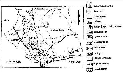
Figure 13: Zio basin tenure (Akibodé, 2000) 4.4
Impacts of human action
According to estimates' of FAO and OIBT (International
Organization of Tropical Wood) during 2000 to 2004, several million forest
hectares disappear in developing countries and this in despite the world forest
community mobilization. In West Africa, more than 2/3 of wooden surfaces
disappeared these last decades. In this context that Zio basin forest
destruction is registered.
The history recalls that it quasi totality of the basin was
covered by an abundant forest, including gallery forest before the human
occupation (GAYIBOR, 1988); just as of other work (ORSTOM, 1967), agree to
recognize vegetable cover importance in pass and devastations operated by the
man. Thus, basin forests degradation led to:
- Marked fall of the soil fertility, made
uncultivated following, an accelerated migration of the fine particles (effects
of deflocculating of clays and dispersion of colloids); none recycling of the
organic matter; an induration's of the pedological profiles;
- River and effluents silting, due to the
important deposits of alluvial loads continuation to the draining making
intermittent the flow and difficult for economic activities depended to the
river exploitation;
- Loss of biological diversity, floristic and
fauna richness basin consequently its economic capital in long term as regards
wood in all its forms, products of fishing and hunting;
- Progressive basin turning into a desert,
justified with the increasingly noticed presence of certain woody species like
Adansonia digitata commonly called «Baobab»
characteristic of the zones strongly touched by the phenomenon;
- Extension of «badlands» reduced cultures
surfaces, leading to the fall of the agricultural outputs and
consequently incomes of the riverside residents.
Taking into consideration of precedes; it can admit that the
vegetable cover is used of natural screen guard or against grounds erosion and
Zio river silting up. The chart below indicates the various sites of the basin
affected by degradation.
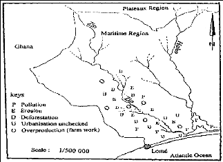
Figure 14: Indicators chart of Zio basin environmental
degradation (Akibodé, 2000)
5 SOLUTION APPROACHES OF RIVER SILTING UP AND
BASIN
DEGRADATION
Zio basin can be considered as a territorial entity,
ecologically rich which would have known in the pass an environmental
stability. But, nowadays, the situation of strongly increasing population it
undergoes a considerable degradation of its natural resources such as forest
formations. The major environmental problems in the basin are:
· Deforestation about culture, charcoal and wood
production;
· Soil impoverishment by hydrous erosion and human
factors;
· River banks instability (degradation);
· Zio River silting up and water resources lacking;
· Eutrophication;
· Air and hydrous pollution;
· Biological diversity in loss;
· Desertification (soil degradation ...).
Solution of these problems requires urgent measures of
environmental protection and dispositions go from defense to respect basin
dynamics function. In fact, the problem of management of the basin environment
and natural resources arise in term of prevention and conservation: prevention
of the damage which can inflict the combined effects of poverty and development
efforts and rare resources conservation and fragile forest ecosystems.
This study proposes to make a global and integrated solution
of the environmental problems. Thus, it considers a multitude effective
solution experimented in the country or in the West Africa to fight in general
against erosion and river silting. Process, regarding basin reforested by
»Taungya system» with idea to promote agroforestry, and to manage
effectively bush fires practice, to protect the biodiversity, to sensitize the
bordering populations, to limit or control eutrophication, to practice
inexpensive anti-erosive measurements and control soil erosion.
Agroforestry, an innovative farming approach includes the
culture of the trees and shrubs providing, fruits, nuts, fibres, medicinal
substances, heating and work wood. Experiences show that this mode improves
peasant food, also other existing conditions. Tongya technical allows the
peasants to associate crop and wood production.
5.1 Basin reforestation and fire management
Reforestation is replanting and maintaining the trees,
keystone of fight against deforestation, desertification and soil
impoverishment. Basin vegetable cover degradation appears like thorough that
the idea of a systematic prohibition of any form of exploitation comes at to
mind. Also, the regulation is the legal way to submit the wood owners to the
principles of environmental and natural resources protection.
However, it will be more judicious to intensify the national
policy of reforest instituted since 1977 (1 st June, Tree Day) in the basin.
Rehabilitation of the old clearings is an alternative to be considered.
In a general way, efforts of reforestation are far from
compensating the fires destruction often practiced by the peasant breeders to
facilitate herbaceous carpet pushes back for the pasture. In addition to the
suitable regulation for the practice of fire, restraint measures considered
relate to the massive introduction of fodder species of substitution making
allow herds to wait the first rains and the new vegetable.
For this forest settlement or natural vegetation restoration,
several objectives can be associated through the wood production or firewood
for other uses, such as agroforestry, timbering of the village tributary of the
river regarding Taungya principles following the strategy proposed in Table 7
below:
Table 7: Agroforestry strategy to limit erosion effect in
basin
|
Agroforestry practice
|
Category Species
|
Propagation Method
|
Uses
|
|
Live-fencing and basin
boundaries
|
Chosen
following
soils
taxation
(vocation,
study)
|
Exotic (E)
|
Cuttings
Cutting/seed
Seed, Suckers
|
Protection, Fibre
Fruit, Timber/Poles
Fuelwood &
Windbreak
Protection
|
|
Indigenous
(In)
|
Truncheons
Truncheons/Seed
Seed left to grow
|
Protection, Fruit,
Firewood, Timber,
Medicinal, Fodder,
Seed,
Shade
Nutrients Alleviation
Protection
|
|
Trees in Pasture Land
|
|
Vegetable
Garden/Homesteads
|
E
|
Left to Grow/Planted
Left to Grow
|
Shade, Fodder, Fertilizer,
Fruit, Timber, Fuelwood
|
|
In
|
Left to Grow/Planted
|
Timber, Shade, Seed
|
|
Trees in Cropland
Conservation Structures
|
|
E
|
Seed/Buds
Seed, Sucker
Seed/Graft
Cutting
|
Fruit, Fuelwood, Poles
Medicine
|
|
In
|
Left to Grow
Left to Grow/Planted
|
Fruit, Fuelwood, Poles
Medicine, Timber
Nuts,
Sculpture
|
|
E
|
Seed/Graft, Seed
Planted
|
Fruit, Shade, Poles
Timber, Fuelwood
|
|
In
|
Left to Grow/Planted
Left to Grow
|
Live fencing & Medicine,
Poles
Fuelwood,
Fodder
Carvings, Shade, Food,
Fruit, Fertilizer
|
5.2 Biodiversity protection
Only by taking account of information received from the
riverside residents, it is can think indeed that impoverishment in biological
resources of the basin would be accelerated considerably with the population
increase. Also, although specifically inventories do not prove the hypothesis,
it estimates with the rhythm of current deforestation that several hundreds of
floristic and fauna species are threatened of extinction or disappear.
Face to this situation, it is pressing to protect the basin
zones being of ecological interest not only ethical but also economic. Aside,
Wouto forest classified, the complex forest of Eto-Lili in rehabilitation, some
forest gallery maintained and Bayémé Zoo restoration project in
sight by Ministry of Environment and Forest Resources, it can create in the
strongly degraded zones other forest reserves and integral surfaces protected
with participative management like Togodo and Amakpapé forests
classified respectively in the Mono and Haho basins and this by taking account
soil vocation and bordering populations daily considerations.
5.3 Fight against eutrophication
According to Ryding and Rast, fighting key is the
bio-filtration process which is efficient and consists in enhancing large
filtrating zooplankton. Amount of zooplankton filtrating needs to balance
respective phytoplankton production, which can be achieved by appropriate fish
stock management. Daphnia sp. is organism recommended for phytoplankton removal
by filtration.
Also, denitrification process through this
balance equation: NO3- -* NO2, is chemical reaction
only takes place under anoxic conditions. Thus, the bacteria employ the
NO3- as source of oxygen. Many saprophytes carry
out the process such as Micrococcus, Spirillum, Bacillus, Escherichia, and
Pseudomonas ...
Two others strategies with their methods can be using to
control and restrict eutrophication in Zio river and lake (Lac-Togo); they are:
Ecological control variable and Technological measures outline (Table 8)
below:
|
Eutrophication control
|
|
Ecological control variable
|
Technological/Ecotechnological measures
|
|
External nutrient-load from the
drainage basin
|
* Control of point sources : sewage
treatment,
algal ponds, sewage diversion from the catchments
area,
water-saving technologies in industrial
establishments, reduction of liquid
manure losses in
animal husbandry, low P-content in detergents ;
* Control of diffuse sources : protective
zones,
proper application of fertilizers, soil stabilizing-
technical in
agriculture, afforestation, seepage
trenches, pre-dams, P-elimination plant,
reed belts,
retention basins for storm water
|
|
Internal load
from the
sediment
|
Phosphorus
|
* Hypolimnion aeration
* Injection of nitrate into the lake sediment
|
|
Nutrient
|
* lake bottom sealing *
sediment dredging
|
|
Export of nutrients by discharge
|
Deep water release (reservoirs)
|
|
Export of phosphorus into the
sediment
|
Precipitation by means of Al- or Fe-minerals
|
|
Water residence time
|
Flushing with water low in nutrients
|
|
Phytoplankton sedimentation
|
* Subdivision of the water body by baffles
* Introducing mineral substances
|
|
Zooplankton growth
|
Produce artificial feeding of zooplankton during
the lack
seasons
|
|
Zooplankton mortality
|
Reduction of zooplankton eating fish by high stocks of predacious
fish (biomanipulation)
|
Source: Ryding and Rast in «The Control of
Eutrophication of Lakes and Reservoirs»
(vol.1, 1989, USA)
5.4 Bordering populations awareness
According to the dictionary Larousse (1990), quoted by KLASSOU
(thesis, 1996), «environment, is the unit, at a moment, physical agents,
biological and the social factors likely to have a direct or indirect,
immediate effect or in the long term, on the living organisms and the
activities human». From this definition, it can admit that the Man takes a
significant part in the environmental degradation, his space life.
Nowadays, environmental degradation is a serious concerns
subject in many areas of the world; thus, many projects of development and
institutions charged to protect the environment tried to solve the problem in
margin of the populations, but the objectives appeared out of attack. The
failure comes from the ascribable start to the fact that did not know to
realize environment management contained also socio cultural dimensions.
It is thus convenient, for the sustainable development of the
Zio basin, to involve directly all bordering populations; by sensitizing on the
principles of participative local development, the awakening of the
environmental stakes of site users. It acts, to some extent to include so much
the aspect environment in all socio cultural activities; to develop
relationship between culture and environment at all levels; to integrate the
concept into lived daily of the populations so as to respond them face their
own becoming.
5.5 Anti-erosive measurements and soil erosion
control
There are several technical to protect basins slopes and
courses water against the silting up. Those which can be adapted in Zio basin
are stop shoulders, renewable organic matter stock; establish anti-erosive
works, drainage, contour and terraces crop. Not very expensive, they were
tested successfully in Ghana, Togo neighboring country, precisely in Volta
valley:
- Stop shoulders, as their name indicates,
they stop sediments transported by surface waters and are built either using
plants perennial settings in hedge laid out perpendicular to the slopes either
carried out starting from stone or deadwood. It can associate two manners to
reinforce the fight. Also, benches settlement is effective to fight against
erosion. Benches technical, is practiced to slow down erosion speed, with the
intercalated cultures (tomato, corn, bean, groundnuts etc...); alleys of
benches are used to cultivate the graminaceous consumable or not.
- Organic matter stock reconstitution, to
rehabilitate a temporarily abandoned ground, it can carry out the mechanical
clearing to make clean the culture field; the peasant can give again a
structure supporting the ventilation of the ground by some animal and vegetable
wastage (scum of sugar cane so much produces in the basin);
- Cultures in contours line and terraces, to
intensify the protection of the slopes emphasized, it can practice the culture
in contours, a culture established according to the level lines; balks of
culture, obstacles to the surface waters cross the slope following his
undulation. Terrace cultivation practiced to slow down speed of surface waters
in staircases or levels;
- Work anti-erosive and drainage, it
reinforces the device enumerated above and relates construction of the water
channels which will substituted drains, gullies and ravines. Laid out slopes
parallel, this latter will be used to evacuate surface waters towards the
principal flow; grids will be posed at the ends of the channels so to avoid
their filling up by clearing products.
In the low of the slopes, dams and stakes of stop are indicated
to fight against hydrous
erosion; they resist the attacks of water and last
a long time when they are out of concrete.
The latter block the sediments of erosion which can be taken to
rehabilitate the slopes exposed by water or for other work.
About soil erosion and according to Meyer and Wischmeier (USA,
1980) quoted by Fenli (CIPSEM, 2007), soil erosion control in river basin can
use Erosion Prediction Model which allow to, develop easily a
reasonable estimate of soil loss, manage soil adjusted decisions, evaluate
management impacts and assess resource inventory. This model uses Revised
Universal Soil Loss Equation, Version 2 (RUSLE 2) which is:
A = EI x K x LS x C x P x SSF
Where:
A = Average annual soil loss in tons/acre/year; EI = Rainfall
energy and intensity; K = Soil erodibility (Texture, Structure); LS = Slope
length, grade, shape; C = Cover-management factor (Rotation, Tillage); SSF =
Adjustable factor for Slope shape; P = Supporting practices (Terraces,
Contours, Buffers)
Soil discharge quantity obtained per year will be an indicator to
know if the basin area concern will submit with reforest or not.
6 CONCLUSION AND RECOMMENDATIONS
The project to fight against Zio river silting up and erosion
in the basin requires a perfect knowledge of the zone and its state of
degradation so to identify suitable measurements of fight. Those are concerned
which made object of this study resulting from its work arrived at the
conclusions and recommendations hereafter:
- From the geological and geomorphologic point of
view, basin of Zio is cutting in a sedimentary material sandy and clay
with low water holding capacity; which justifies the fast infiltration of the
an important volume rainwater to be collected towards the principal flow;
- River silting up and erosion, in the basin are
the major problems of degradation due to the combined effects of the factors
natural and human of destruction of the environment;
- Zio river in the coastal sedimentary basin
runs, in a channel of relatively weak unevenness whose value of the
slopes does not exceed 2%; what facilitates the deposit of loads during the
falls and low water levels contributing to the stranding of the river bed;
- Degradation of the basin forestry cover, has
naked the grounds is the principal cause of erosion.
To protect Zio river banks and fight against erosion in the
basin, the study recommends the participative and sustainable reforestation
with the idea to promote the agroforestry and to manage the bush fires
effectively, to protect the biodiversity, to limit eutrophication, to sensitize
the bordering populations, to control soil erosion and put anti-erosive
measurements into practice.
Although efforts are in hand on the various sectors level
concerned with management studied zone to constitute a data base, there is a
crucial lack reliable and recent data on sedimentary basin coast. This
situation does not encourage initiative to undertake studies on the area. Thus,
it pressing for the ministries concerned regarding question to create
harmonized data base on the sedimentary basin coast and with need together for
all territory with for coordinator the Ministry of Environment and Forestry
Resources.
We are convinced if all these measurements taken into account
and implementations, it obvious that very soon the environment of a favorable
environment for the bordering populations will reappear in the basin.
To finish, we launch a call to all those which work for
fundamental research in connection with river basins, in particular those of
the coastal sedimentary basin of Togo, to take account of the well-elaborated
intentions in the various work studies. It through this frank scientific
collaboration, the spirit of interdisciplinary can really contribute to the
human and sustainable development of our country.
REFERENCES
ADDRA, H (1975): Erosion régressive au quaternaire
récent et modèle du plateau de terre de barre (exemple du plateau
de Vogan), Ann, Univ du Bénin, série Lettres Tome 2,
no 2 Lomé, pp 30-49.
AKIBODE, A. S. Nelson (2000): Contribution a l'Etude Hydro
geomorphologique de la Basse vallée du Zio, Memo, Univ du Benin, Lome,
75 p
ANONYME (1981): Périmètre irrigué du Zio,
étude socio-économique, Rapport SOTED, Direction du Plan,
Lomé, 48 p.
BLIVI, A (1993): Géomorphologie et dynamique actuelle du
littoral du Togo (Afrique de l'Ouest), Thèse de Doctorat, Bordeaux, 458
p.
CHURCH, H et MOSS, R. P (1980): West Africa, a study of the
environment of man's use of it, Londres, 526 p
COLOMBANY, J (1968): Notice hydrologique sur le Bassin du Zio
à Kpédji, ORSTOM, Lomé, 42 p.
COUDRAY, J et BOUGUERA, M. L (1994): Environnement en milieu
tropical, ESTEM, Paris, 19 p.
GNONGBO, T. Y (1989): Contribution à l'étude
géomorphologique de la basse vallée du Zio, Mém, Univ. Du
Bénin, Lomé, 124 p.
GU-KONU, Y et al (1981): Atlas du Togo, J.A, Paris, 64 p.
HERVIEU, J (1968): Contribution à l'étude de
l'alluvionnement en milieu tropical, Mém, ORSTOM, n0 24, Paris, 58 p.
IROKO, O. Yao (2006): Fondements pour l'Elaboration du
Schéma Directeur de l'Aménagement Environnemental de la
Région des Plateaux, Mém, InSTEC, La Havane/Cuba,
JOHNSON, K (1987): Le Bassin côtier à phosphates du
Togo, Thèse, Univ. de Bourgogne- Dijon, 248 p.
KLASSOU, K. S (1989): Impact du climat sur l'évolution du
régime hydrologique, le cas du Zio et du Haho, Mém, Univ du
Bénin, Lomé, 120 p.
Martin, P. Wanielista (1990): Hydrology and Water Quantity
Control, Univ. New York, USA MICHEL, P (1990): Géographie physique
tropicale (Approche aux études du milieu), Karthala-ACCT, Paris, 351
p.
NORMAN, C (1982): Pluies de grains, pluies de mousson et
environnement dans la zone maritime du Togo, Mém, Univ. du Bénin,
Lomé, 122 p.
PECH, P et REGNAULD, H (1992): Géographie physique PUF,
Paris, 315 p.
PIERRE, G (1974): Dictionnaire de la Géographie PUF,
Paris, 346 p.
RYDING, S.O. and RAST, W. (1989): The Control of Eutrophication
of Lakes and Reservoirs, MAB (UNESCO) Vol. 1, Paris, 314 p.
SLANSKY, M (1962): Contribution à l'étude
géologique du bassin sédimentaire du Dahomey et du Togo,
Mém du BRGM, no11, Paris, 270 p.
SOGBEDJI, M (1987): Etude de la pluviométrie au Togo
Méridional, Rapport ORSTOM, Lomé, 24 p.
TIMO PUKKALA and KALLE EERIKAINEN (1998): Modelling the growth
of tree plantation and agroforestry system in South and East Africa, The
University of Joensuu, Falcuty of Forestry, Reaseach Notes 80, 1998, 256 p.
VIMARD, P (1979): Enquêtes démographiques sur la
Région Maritime, ORSTOM, Lomé,
34 p.
CHARTS AND FLY PHOTOS DOCUMENTS USED
- Togo topographic charts/ 1/50 000 IGN, Paris, 1954,
covering study zone:
1.
|
Kouété
|
Feuille NB-3 1 -XIX-2b
|
2.
|
Kati
|
Feuille NB-3 1 -XIII-4d
|
3.
|
Palimé
|
Feuille NB-3 1 -XIV-4b
|
4.
|
Lomé 3a
|
Feuille NB-31-XIV-3a
|
5.
|
Lomé 1c
|
Feuille NB-31-XIV-1c
|
6.
|
Lomé 1d
|
Feuille NB-31-XIV-1d
|
7.
|
|
Lomé 1b
|
Feuille NB-31-XIV-1b
|
|
- Fly photography/ 1/30 000, Maritime Region covering
study zone:
1.
|
Vol. 77-TOG-31/300:
|
2475
|
- 2476
|
- 2477
|
- 2478
|
- 2479
|
- 2480
|
|
|
2491
|
- 2492
|
- 2493
|
- 2494
|
- 2495
|
- 2496
|
2.
|
Vol. 78-TOG-31/300:
|
3368
|
- 3369
|
- 3370
|
- 3371
|
- 3372
|
- 3373
|
3.
|
Vol. 79-TOG-31/300:
|
3584
|
- 3385
|
- 3586
|
- 3587
|
- 3588
|
- 3589
|
TABLE OF FIGURES
1. Study area chart localization and geology
2. Curves of the monthly average temperatures of the basin over
25 years
3. Rainfall graphs of the monthly averages of the basin over 30
years
4. Curves of evolution of the monthly averages of sunstroke and
evaporation in the basin
5. Water supply of the Zio river
6. Zio catchments area and hydrographic network
7. Curves of evolution of annual average precipitations over 20
years
8. Curves of annual medium flows of Zio over 21 years period
9. Curves of evolution of Zio flowing over 21 years
10. Zio alluvia terraces space provision
11. Recognizing Zio valley geomorphology sketch in coastal
sedimentary basin (Akibodé, 2000)
12. Zio basin topographic sketches indicating the silting up
level
13. Zio basin tenure (Akibodé, 2000)
14. Indicators chart of Zio basin environmental degradation
(Akibodé, 2000)
Sources:
TOGO:
. Ministère de l'Environnement et des
Ressources Forestières
. Départements de Géographie, de
Géologie/Université de Lomé
. Direction de l'Urbanisme et du Cadastre
. Ministère de l'Agriculture, de
l'Elevage et de la Pêche
. Ministère des Mines, Energie et
Eau
. Riverains et autres usagers du basin
GERMANY:
. Technische Universität Dresden -
Library/Dresden
. Institute of Soil Science and Site
Ecology/TUD/Tharandt
. Ministry for the Environment, Nature
Conservation and Nuclear Safety, Berlin . Centre for
International Postgraduate Studies of Environmental Management (CIPSEM)/TUD
. Neunzehnhain Ecological Station: Training and
research Center of Water Engineering Department of the Faculty of Forestry,
Geo- and Hydrosciences TUD
. The International Academy for Nature
Conservation, Isle of Vilm . German National Park
. Regional Commis sion/Council Integrated Rhine
Programme, Freiburg
Others:
. Czech Republic: Institute of System Biology
and Ecology, Academy of Sciences of the Czech Republic, Ceske Budejovice &
Prague
. France: National School for Water and
Environment Engineering, Strasbourg (Research Centre in Agricultural and
Environmental Engineering)
|
|


