|
NATIONAL UNIVERSITY OF RWANDA

CENTRE FOR GEOGRAPHIC INFORMATION SYSTEMS AND REMOTE
SENSING (CGIS)
LANDFILL SITES SELECTION FOR MUNICIPAL SOLID WASTE
USING MULTI CRITERIA EVALUATION
TECHNIQUES.
Case of Rusizi Town, Rwanda
Individual Case Study done in the partial fulfillment for
the award of the Post Graduate Diploma in Applied Geo-Information
Science
By Fidèle RUGIRAMANZI
Supervisor: Mr. Theodomir MUGIRANEZA
June, 2013
DECLARATION
I declare that the dissertation hereby submitted in the
partial fulfillment for the award of the Post Graduate Diploma in Applied
Geo-Information Science at the National University of Rwanda/ Centre for
Geographical Information System and Remote Sensing, is original and has not
been published and/or submitted for any other degree award to any other
University before.
Signed: Date:

Fidèle RUGIRAMANZI
II
DEDICATION
To the almighty God,
To my mother,
To my Brothers and Sisters,
To my Friends, classmates and Colleagues
ACKNOWLEDGEMENTS
Firstly, I give thanks and praise to GOD for everything that
happened in my life.
Much of the work for this project as well as for my study
programme could not have been completed without the help and support of many
people. I would like to thank my supervisor, Mr. Theodomir MUGIRANEZA, I am so
deeply grateful to his help, support, and valuable guidance throughout this
research and my study programme that I do not have enough words to express my
gratitude.
My incredible recognition goes out to my fellow students for
their moral and collaboration during this research.
Finally, special thanks are extended to all institutions and
individuals that supported me in different manner.
My sincere gratitude is expressed to each and every one who
supported me in one way or another to accomplish this research.
III
I COUNT YOU ALL AS A GIFT FROM GOD TO ME: BE EXTREMELY
BLESSED
ABSTRACT
Siting a landfill is an extremely complex task mainly due
to the fact that the identification and selection process involves many factors
and strict regulations. For proper identification and selection of appropriate
sites for landfills careful systematic procedures need to be adopted and
followed. Wrong siting of landfill may have negative environmental, economic
and ecological impacts. In this study, attempts have been made to determine
sites that are appropriate for landfill siting in Rusizi Town of Rusizi
District, Western Province in Rwanda. This was achieved by combining geographic
information system (GIS) and a multi-criteria evaluation technique. For this
purpose, ten input map layers including Roads network, Rivers, Kivu Lake,
wetlands, forests, airport, markets, health facilities, schools and slope were
prepared. A constrained area was created with respect to 100m buffer from the
roads, 300m buffer from rivers, forest, wetlands and Kivu Lake, 1000m buffer
from schools, health facilities and market and 3000m buffer from Kamembe
airport. The final map was produced after spatial overlay of permissible area
and suitable slope of between 8 and 12%. The final output was produced where
133 sites were identified to fulfill the required criteria; among them five met
the land size criteria requirement of 2 hectares and above for a potential
landfill site. 04 potential sites were identified in Mururu Sector while 01
potential site was identified in Gihundwe Sector. However, during this
research, the lack of some of the required data such as ground water levels and
geologic data that may improve the quality of the final result was among the
problem faced due to time and budget constraints. The results showed
the efficacy of GIS and multi-criteria evaluation technique in decision making,
while dealing with complex and conflicting criteria.
iv
Keyword: Landfill, Site selection,
Municipal Solid Waste, Multi Criteria Evaluation Technique
V
TABLE OF CONTENTS
DECLARATION I
DEDICATION II
ACKNOWLEDGEMENTS III
ABSTRACT IV
TABLE OF CONTENTS V
LIST OF TABLES VII
LIST OF FIGURES VIII
LIST OF ABBREVIATIONS AND ACRONYMS IX
CHAPTER 1: GENERAL INTRODUCTION 1
1.1. BACKGROUND OF THE STUDY 1
1.2. PROBLEM STATEMENT 2
1.3. RESEARCH OBJECTIVES AND RESEARCH QUESTIONS 3
1.4. SCOPE OF THE RESEARCH 4
1.5. RESEARCH CONTRIBUTIONS 4
CHAPTER 2: LITERATURE REVIEW 5
2.1. SOLID WASTE CATEGORIES 5
2.2. SOLID WASTE MANAGEMENT 6
2.2.1. Source reduction 6
2.2.2. Recycling 6
2.2.3. Waste transformation 7
2.2.4. Landfilling 7
2.3. CRITERIA FOR LANDFILL SITING 9
2.3.1. Environmental Criteria 9
2.3.2. Political Criteria 10
2.3.3. Economic Criteria 11
2.3.4. Hydrologic/Hydrogeologic Criteria 12
2.3.5. Topographical Criteria 12
2.3.6. Geological Criteria 12
2.4. GIS AND MULTI CRITERIA TECHNIQUES IN SITE SELECTION 13
vi
CHAPTER 3: STUDY AREA AND METHOLOGY 14
3.1. STUDY AREA DESCRIPTION 14
3.2. DATA AND MATERIAL 15
3.3. METHODS AND TECHNIQUES 15
3.4. DATA ANALYSIS AND INTERPRETATION 18
CHAPTER 4: WASTE GENERATION AND MANAGEMENT IN RUSIZI:
BOTLENECKS' ANALYSIS AND SUITABLE
LANDFILL SITES LOCATION 19
4.1. WASTE GENERATION AND MANAGEMENT IN RUSIZI TOWN 19
4.2. GAPS AND CHALLENGES IN WASTE MANAGEMENT IN THE TOWN OF
RUSIZI 20
4.3. SITE SELECTION FOR LANDFILL IN RUSIZI TOWN 21
4.3.1. Criteria for site selection 21
4.3.2. Landfill site determination 23
4.4. POSSIBILITIES FOR LANDFILL SITES PROJECT IMPLEMENTATION
31
CHAPTER 5: GENERAL CONCLUSION AND RECOMMENDATIONS
32
5.1. GENERAL CONCLUSION 32
5.2. RECOMMENDATIONS 33
REFERENCES 35
vii
LIST OF TABLES
Table 1-1 : Research objectives and questions
3
Table 4-1 : Evolution of Solid waste by Sector in the Town of
Rusizi .. 19
Table 4-2 : Composition of Waste in Rusizi Town 19
Table 4-3 : Proportions (in %) of dwelling units according to
mode of disposal of household
waste in the town of Rusizi 21
Table 4-4 : Suitable Sites and their areas (in Sqm) 27
Table 4-5 : Potential landfill sites .. 29
Table 4-6 : Location of potential landfill sites 29
VIII
LIST OF FIGURES
Fig 2-1 : Waste management hierarchy 8
Fig 3- 1 : Location map of the study area 14
Fig 3-2 : Model builder for Factor Map 16
Fig 3-3 : Model builder for Constraints Map 17
Fig 3-4 : Model builder for Final Map . .. 18
Fig 4-1 : Rusizi Town MSW management related problems 20
Fig 4-2 : Slope analysis 24
Fig 4-3 : Constrained and permissible area . .. 25
Fig 4-4 : Distribution of Suitable sites in Rusizi Town 26
Fig 4-5 : Distribution of Potential landfill sites in Rusizi
Town 28
Fig 4-6 : General Suitability Map . 30
ix
LIST OF ABBREVIATIONS AND ACRONYMS
CBD : Central Business District
DEM : Digital Elevation Model
CGIS : Centre for Geographic Information
Systems
MCE : Multi Criteria Evaluation
MCET : Multi Criteria Evaluation
Techniques
MININFRA : Ministry of Infrastructure
MSW : Municipal Solid Waste
NGO : Non Governmental Organization
NIABY : Not in anyone's backyard
NIMBY : Not in my backyard
NUR : National University of Rwanda
REMA : Rwanda Environment Management
Authority
RNRA : Rwanda Natural Resources Authority
RURA : Rwanda Utilities Regulatory
Authority
1
CHAPTER 1: GENERAL INTRODUCTION
This study aimed at finding out potential landfill sites for
Municipal solid waste in the town of Rusizi. This chapter presents the
background of the study, problem statement, research objectives and research
questions, scope of the research and research contributions.
1.1. Background of the study
Municipal solid waste (MSW) collection and disposal is a major
problem associated with the urban development in different countries. It has
also been recognized as one of the major problems confronting governments and
city planners the world over (Rahman & Hoque, 2006). It is estimated that
the United kingdom produces 35 million tones of municipal solid waste
annually(Koshy, Emma, Sarah, Tim, & Kelly, 2007) and in the United states
of America, more than 140 million tones of municipal waste is generated
annually, while Japan and Germany generates 50.2 million and 43.5 million tones
of municipal wastes in 1993 respectively(Sakai et al., 1996). In Africa, the
situation appears to be the same as other parts of the world (Babalola &
Busu, 2011).
In the developing countries, municipal solid waste management
system is either not efficient or still at the rudimentary stage and as such
solid waste generated has become a threat to the environment (Babalola &
Busu, 2011). According to (Weigand, Fripan, Przybilla, & Marb, 2003) the
«Lack of MSW management leads to significant soil, water, air aesthetic
pollution associated human health problems, as well as an increase in
greenhouse gases emission».
In urban areas of developing countries massive wastes
generally consist of domestic garbage, organic litter, plant leaves, branches,
logs, spoiled agric produce, crop residues, bad food materials, pieces of
paper, polythene bags, rags, vehicle scraps, used tires, dusts, mire, plastics,
glass, blood, bones, animal skins, hides, leather, urinary and fecal materials.
When these wastes are improperly disposed-which is generally the case; they
constitute a threat to air, water, land, vegetable, wildlife and man. Sickness
and disease epidemics often occur when sewage, garbage wastes and unwanted
substances are not properly disposed of and well managed (Awomeso, Taiwo,
Gbadebo, & Arimoro, 2010).
For a sustainable solid waste management, system policies and
techniques such as waste recycling, reuse, waste reduction, thermal treatment,
landfilling must be in place. The landfill
2
method has been widely recognized as the most used of all the
waste management techniques and sanitary landfill is the most cost-effective
system of solid waste disposal for most urban areas in developing countries
(Nas, Cay, Iscan, & Berktay, 2010).
Several studies have been conducted on different scales to
find the optimum locations for solid waste disposal sites. The selection of
their ultimate site is complex. It must combine social, environmental,
technical and economical parameters. Also, the location must comply with the
requirements of the governmental regulations in order to be acceptable
(Al-Hanbali, Alsaaideh, & Kondoh, 2011).
According to (RURA, 2011) no landfill site shall be located in
any area where it is likely to have a significant negative impact on existing
land uses, the location of the landfill should not give rise to any adverse
effects or a significant risk of any adverse effects occurring». For a
sustainable urban development, it is imperative not only to set up an effective
system for waste collection and transport but also a selection of a suitable
site for waste deposition.
To do so, a Multi-criteria evaluation (MCE) technique is used
to deal with the difficulties that decision makers encounter in handling large
amounts of complex information. The principle of the method is to divide the
decision problems into more smaller understandable parts, analyze each part
separately, and then integrate the parts in a logical manner (Malczewski,
1997).
1.2. Problem statement
Rwanda cities are growing day by day. Due to the population
growth and the improvement of life standards, there is a growing concern
associated with waste generation. Some efforts were made to handle the urban
waste, but there are still some weaknesses related to the selection of suitable
sites for waste disposal. According to (REMA, 2010) waste disposal facilities
remain inadequate in resettlements (imidugudu), small towns and cities
throughout Rwanda.
In rural areas, organic waste is composted and mixed in
fields. Other types of waste are reused or put underlay. In urban areas, the
local administration usually manages solid waste collection and disposes waste
in open dumpsites.
3
Research has been done in the field of landfill site selection
for municipal solid waste in different countries and particularly in Rwanda, in
the City of Kigali, using GIS overlay analyses. While ideal for performing
spatial searches on nominally mapped criteria, these GIS overlay analyses are
limited in use when multiple and conflicting criteria and objectives are
concerned. MCE techniques offer means for making and supporting complex siting
decisions, involving multiple criteria (STEPHEN, 1991).
In addition, their results cannot be efficiently and
effectively used for the case of Rusizi Town without any modifications due to
the heterogeneity of economical, environmental, political and social parameters
that were used in other countries and cities. Therefore, this research is a
contribution to the site selection and determination in secondary city of
Rwanda such as Rusizi using state-of-art-technology like MCET.
1.3. Research objectives and Research questions
The main objective of this study is to identify/ show sites
for municipal solid waste in Rusizi Town using MCET. In order to achieve the
main research objective, the following specific objectives and research
questions were answered in this research.
Table 1-1: Research objectives and questions
|
Specific objectives
|
Research questions
|
1.
|
To assess the current situation of waste generation and
management in Rusizi Town.
|
What is the quantity of waste
generation per day?
What are the techniques used to select
waste disposal in Rusizi Town?
|
2.
|
|
To assess the suitability of the current landfill sites.
|
What are the criteria fulfilled by the current landfill sites?
|
|
|
3. To determine suitable site(s) for landfill for waste
dumping
|
|
What are the suitable locations of landfill sites for each
Sector?
How many potential landfill sites for
waste dumping in Rusizi town?
|
4
1.4. Scope of the Research
The study only covers the municipal solid waste in the Town of
Rusizi that is made of Kamembe, Gihundwe and Mururu Sectors. The design,
operations and maintenance of a landfill is out of the scope of this
project.
1.5. Research contributions
This research makes a contribution to the literature in terms
of landfill site selection. The result will always help city management
officials to quickly identify and select suitable landfills for municipal solid
waste disposal. In addition, it will help managers to cut down the time spent
debating location based problems as well as reduce costs.
5
CHAPTER 2: LITERATURE REVIEW
This chapter is about the review of literature on solid waste
management. The first part of this chapter discussed solid waste categories,
the second parts identifies different technologies that are used in solid waste
management, the third part identifies various criteria that are taken into
consideration in landfill siting, while the fourth part presents the role of
GIS and MCE in site selection.
2.1. Solid waste categories
Rubin and Davidson (2001), created two classes of solid
wastes: hazardous and nonhazardous. A hazardous waste was defined as «
a solid waste or combination of solid wastes which because of quantity,
concentration, or physical, chemical, or infectious characteristics may (1)
cause, or significantly contribute to, an increase in mortality or an increase
in serious irreversible , or incapacitating reversible illness; (2) pose a
substantial present or potential hazard to human health or to the environment
when improperly treated, stored, transported, or disposed of, or otherwise
managed.»
On the other hand, wastes that are not designed as hazardous
are said to be non-hazardous. The most familiar type of nonhazardous waste is
what we commonly call trash or garbage. These are components of municipal solid
waste (MSW) which includes all of wastes commonly generated in residences,
commercial buildings ( like shopping smalls, restaurants, and corporate
offices), and institutional buildings (such as universities and government
offices). MSW consists of such things as paper, packaging, plastics, food
wastes, wood and discarded appliances. Similar kinds of wastes generated by
industrial facilities also are part of MSW. The additional wastes generated by
manufacturing processes, construction activities; mining and drilling
operations, agriculture, and electric power production are distinct from MSW
and are referred to as industrial wastes.
Pandey and Carney (2005) identify 2 broad categories of solid
waste materials:
Household solid waste where household solid materials are
collected locally and the amount depends upon the size and consumption habits
of the population. Commercial wastes that are generated by commercial
establishments but are usually disposed off by public facilities.
6
2.2. Solid waste management
Solid waste management may be defined as the discipline
associated with the control of generation, storage, collection, transfer and
transport, processing and disposal of solid wastes. Integrated solid waste
management includes the selection and application of suitable techniques,
technologies and management programs to achieve specific waste management
objectives and goals (G. Tchobanoglous & Kreith, 2002). However, current
solid waste management technologies can be summarized as:
1) Source reduction
2) Recycling
3) Waste transformation
4) Landfilling
2.2.1. Source reduction
It involves diminishing waste amount, volume and toxicity at
the source of waste generation (Kreith, 1994). Source reduction is the most
effective way which reduces the quantity of waste, the cost of associated with
its handling, and its environmental impacts. Waste reduction may occur through
the design, manufacture, and packaging of products with minimum toxic content,
minimum volume of material, or a longer life and also at the household,
commercial, or industrial facility through selective buying patterns and the
reuse of products and material (G Tchobanoglous & 1993).
2.2.2. Recycling
It involves (1) the separation and collection of waste
materials; (2) the preparation of these materials for reuse, reprocessing, and
remanufacture; and (3) the reuse, reprocessing, and remanufacture of these
materials. Recycling is an important factor in helping to reduce the demand on
resources and the amount of waste require disposal by landfilling (G
Tchobanoglous & 1993). Reusing waste products can be simply made by the
public by returning drink containers to bottling manufacturers and the donation
of used clothes, shoes, furniture, and electrical products to charities and
retailers. Product recycling primarily involves melting glass and metals,
pulping of paper waste so that the end product is useful as a raw material to
manufacturers. Benefits of waste recovery include conserving finite
7
resources, lowering the need for mining or harvesting virgin
material, reducing inert residues from incinerators, and fewer demands on
landfills (Kreith, 1994).
2.2.3. Waste transformation
It involves the physical, chemical, or biological alteration
of wastes. Typically, the physical, chemical, and biological transformations
that can be applied to municipal solid wastes are; (1) to improve the
efficiency of solid waste management operations and system, (2) to recover
reusable and recyclable materials, and (3) to recover conversion products and
energy in the form of heat and combustible biogas. The transformation of waste
materials usually results in the reduced use of landfill capacity
(Tchobanoglous, 1993).
Transformation examples include mechanical clipping,
shredding, and grinding, thermal combustion, and composting organic food and
yard waste (Kreith, 1994). A benefit of thermal incineration is the potential
for energy generation while reducing waste volume up to 90% (Tchobanoglous,
1993).
2.2.4. Landfilling
It is the process by which the solid wastes that cannot be
recycled nor further used; the residual matter remaining after the recovery
facility and after the recovery of conversion products and energy is placed in
a landfill. Although there is a public opposition to landfills, it is necessary
and there is no combination of waste management technique that does not require
landfilling to make them work. Landfilling includes monitoring of the incoming
waste stream, placement and the compaction of waste, and installation of
landfill environmental monitoring and control facilities. Disposing of waste in
a landfill involves burying the waste. A properly-designed and well-managed
landfill can be a hygienic and relatively inexpensive method of disposing of
waste materials. However, poorly-designed or poorly-managed landfills can
create a number of adverse environmental impacts such as wind-blown litter,
attraction of vermin, and generation of liquid leachate (REMA 2010).
Moreover, waste management is the collection, transport,
processing, recycling or disposal, and monitoring of waste materials. The term
usually relates to materials produced by human activity, and is generally
undertaken to reduce their effect on health, the environment or aesthetics.
Waste management is also carried out to recover resources from it. Waste
management can involve solid, liquid, and gaseous substances, with different
methods and
8
fields of expertise for each. Waste management practices
differ for rural, small town, urban or industrial producers (REMA, 2010).
Nevertheless, landfill technique and incinerators are two
methods commonly used for solid waste management (Pandey & Carney, 2005).
Incineration is a disposal method that involves combustion of waste material.
Incineration and other high temperature waste treatment systems are sometimes
described as "thermal treatment". Incinerators convert waste materials into
heat, gas, steam, and ash. Incineration is carried out both on a small scale by
individuals and on a large scale by industry. It is used to dispose of solid,
liquid and gaseous waste. It is recognized as a practical method of disposing
of certain hazardous waste materials (such as biological medical waste).
Incineration is a controversial method of waste disposal, due to issues such as
emission of gaseous pollutants (REMA, 2010).
Fig 2-1: Waste management hierarchy
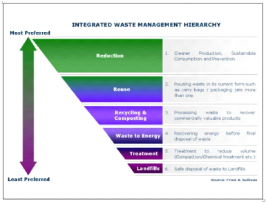
Source: REMA (2010)
To summarize, solid waste management techniques vary from
country to country depending on physical geography, demographics and level of
economic development. Most industrialized countries have regular solid waste
collection and disposal services, waste disposal sites that are by law required
to have at least some environmental prevention and control techniques
(Nakakawa, 2006).
9
2.3. Criteria for Landfill siting
Landfill siting is a difficult, complex, tedious, and
protracted process requiring evaluation of many different criteria (Chang,
Parvathinathanb, & Breden, 2008) since it has to combine social,
environmental, technical, and financial factors. Environmental factors are very
important because the landfill may affect the biophysical environment and the
ecology of the surrounding area ; (Kontos, Komilis, & Halvadakis, 2003);.
Economic factors must be considered in the siting of landfills, which include
the costs associated with the acquisition, development, and operation of the
site (Delgado, Mendoza, Granados, E. L., & Geneletti, 2008).
Social and political opposition to landfill siting have been
indicated as the greatest obstacle for successfully locating waste disposal
facilities (Lober, 1995) . The «not in my backyard» (NIMBY) and
«not in anyone's backyard» (NIABY) phenomena (Chang et al.,
2008);(Kao & Lin, 1996); (Erkut & Moran, 1991); (Kontos, Komilis, &
Halvadakis, 2003); (Lin & Kao, 2005) are becoming popular nowadays creating
a tremendous pressure on the decision makers involved in the selection of a
landfill site.
According to ENER, B. (2004), there are a number of criteria
for landfill site selection. These are environmental criteria, political
criteria, economical criteria, hydrologic and hydrogeological criteria,
topographical criteria, geological criteria, availability of construction
material and other criteria. Each criterion will be discussed briefly in the
next sections.
2.3.1. Environmental Criteria
2.3.1.1. Ecological value of the flora and fauna
The direct and indirect spatial use of a landfill will destroy
the actual vegetation and fauna. When making a decision, the ecological value
of the actual vegetation and fauna should be evaluated carefully for the
candidate area. Ecological value is based on diversity, naturalness and
characteristic feature.
2.3.1.2. Odour and dust nuisance
A new landfill should not be located within a distance of a
housing area because of the dust and odour emissions. Dependent of the local
wind direction and speed, the safe distance necessary to locate a landfill site
should be determined to prevent sensing dust and odour.
10
2.3.1.3. Nuisance by traffic generation
A new landfill will generate more traffic. How much more
traffic depends of the distance to the collection area, the kind of transport
and the use of transfer stations. Access roads passing through housing areas
will cause more nuisance than access roads through the open country side. So,
routing vehicle traffic through industrial, commercial or low density
population areas decreases the noise impacts of landfill related vehicles.
2.3.1.4. Ecological, scientific or historical
areas
Especially national parks and natural conservation areas and
also historical areas are not suitable for the location of a landfill.
2.3.1.5. Tourist/recreation areas
A new landfill should not be planned within an existing
recreational area or adjacent to it. However, a landfill is possible in some
kinds of recreation areas like car/motor racing. Also the final use of a
landfill can be planned as a recreational area.
2.3.2. Political Criteria
2.3.2.1. Acceptance by the local municipalities
The political acceptance of a new landfill location can differ
in each region and sometimes the potential sites are located in different
regions. The level of political acceptance has influence on the willingness of
the local municipalities to make their regional physical plans and to give
permission for the construction of a landfill. The unwillingness will cause to
a delay of the decision on the landfill location
2.3.2.2. Acceptance by the pressure groups involved
The acceptance by the public of a landfill in their own region
or municipality is an important factor in the decision making process. The
so-called NIMBY (not in my backyard) syndrome is becoming a common attitude.
The influence of the public is significant if there are local groups which are
well organized and having good relations with the local authorities and the
media (papers, radio and television). The level of the public acceptance can be
measured how far the local pressure groups are succeeding to delay the decision
making process.
2.3.2.3. Property of the landfill area
The ownership of the needed land for the landfill is very
important. Public ownership is easier than private ownership because the
private ownership will give problems with the cost of the land. Sometimes,
expropriation is needed.
11
2.3.3. Economic Criteria
2.3.3.1. Costs of land
Costs of the land depend on the land prices which can differ
for each location. The actual use of the land is important for the price which
influences the level of compensation for the owner or actual users. The
potential landfill with the lowest costs is more preferable.
2.3.3.2. Costs for the access of the
landfill
Costs for the access of the landfill depend on the condition
and the presence of roads close to the landfill. If reconstruction of actual
roads is needed, the costs will increase. Because of that road network is an
important factor to locate a landfill site.
2.3.3.3. Transport costs
Transport costs are determined by the transport distances from
the source of waste generation, the way of transport and the way of collection.
The other factors affecting transport costs are the need for waste transfer
stations and the possibility to use railways.
2.3.3.4. Costs for personnel, maintenance and
environmental protection
The costs for personnel will not differ so much between the
different potential landfill sites. Maintenance depends on the availability of
soil needed for the daily or regular covering and for the stability of the
landfill. If the soil is not available in the area, it should be imported which
increases the maintenance costs. Extra technical provisions should be placed to
prevent the pollution of the soil, groundwater and surface water at the
landfill. Monitoring the drainage system and the quality of the leachate and
surface water are also important factors in the maintenance costs. The
potential landfill with the lowest maintenance costs is more suitable for a
landfill.
3.3.3.5. Costs for the after-care
The costs for after-care is not only dependent on the kind of
final use but also on provisions to monitor the groundwater quality, existence
of gas, the winning of gas, the stability of the completed landfill. Needed
provisions are depending on the characteristics of the filled waste, the kind
of subsoil, the hydrogeological situation, and the kind of final use.
12
2.3.4. Hydrologic/Hydrogeologic Criteria 2.3.4.1.
Surface water
The landfill site should not be placed within surface water or
water resources protection areas to protect surface water from contamination by
leachate. Safe distances from meandering and non-meandering rivers should be
achieved to prevent waste from eroding into rivers and major streams. A
landfill should not be located within 100 feet (30.48 m) of any non-meandering
stream or river, and at least 300 feet (91.44 m) from any meandering stream or
river. Large ponds, lakes, and reservoirs should have a buffer zone of land to
prevent blown debris and runoff from harming aquatic habitats. Large bodies of
water (greater than 20 acres (80937.45 m2) of surface area) should be at least
100 feet (30.48 m) from any landfill site.
2.3.4.2. Groundwater
To protect subsurface drinking water, landfills should not be
situated over high quality groundwater resources. Fresh groundwater (total
dissolved solids>1000 mg/l) should be avoided or protected with a compound
liner system and monitoring wells (Bagchi, 1994). Since potential leachate
leaks will travel down gradient, landfills should be placed greater than 304.8
m (1000 feet) up gradient from water wells.
2.3.5. Topographical Criteria
The topography of an area is an important factor on site
selection, structural integrity, and the flow of fluids surrounding a landfill
site because it has important implications for landfill capacity, drainage,
ultimate land use, surface and groundwater pollution control, site access and
related operations (Wilson, 1977). Deciding the type of landfill design (area-,
trench-, and depression-type landfills) is directly related to topography of a
site.
2.3.6. Geological Criteria
The geology of an area will directly control the soil types
created from the parent material, loading bearing capacity of the landfill's
foundation soil, and the migration of leachate. Rock and its structure type
will determine the nature of soils and the permeability of the bedrock.
Geologic structure will influence the movement of leachate and potential
rock-slope failure along joints and tilted bedding planes.
On the other hand, RURA states that a landfill site should meet
the following criteria:
The site shall not be closer than three thousand (3,000) meters
from an airport, airfield or site reserved for the construction of an airport
or airfield;
13
The site shall be located and operated in such a manner that
it does not create significant negative impacts on flora and fauna on adjoining
land;
The site shall not be closer than four hundred (400) meters from
an existing residential development;
The edge of the landfill shall not be closer than hundred
(100) meters from an area to which the public have access, a national park,
protected area or an area having national historical or archaeological
significance;
There must be a buffer area around the landfill of at least
twenty (20) meters to allow provision for visual screening from adjoining
properties.
Landfill access roads shall be located and constructed so as
to have a minimum impact on adjacent residents.
2.4. GIS and Multi Criteria Techniques in site
selection
Site selection procedures can benefit from the appropriate use
of GIS. Common benefits of GIS include its ability to: (a) capture, store, and
manage spatially referenced data; (b) provide massive amounts of spatially
referenced input data and perform analysis of the data; (c) perform sensitivity
and optimization analysis easily; and (d) communicate model results (Vatalis
& Manoliadis, 2002).
Multi-criteria evaluation (MCE) is used to deal with the
difficulties that decision makers encounter in handling large amounts of
complex information. The principle of the method is to divide the decision
problems into more smaller understandable parts, analyze each part separately,
and then integrate the parts in a logical manner (Malczewski, 1997) . The
integration of GIS and MCE is a powerful tool to solve the landfill site
selection problem because GIS provide efficient manipulation and presentation
of the data and MCE supplies consistent ranking of the potential landfill areas
based on a variety of criteria (Sener, Suzen, & Doyuran, 2006).
(Higgs, 2006) reported the potential of integrating
multi-criteria techniques with GIS in waste facility location and documented
through a review of the existing literature to highlight the opportunities and
challenges facing decision makers at different stages of the waste facility
management process. Moreover, projects with numerous variables are best
approached in GIS using a multi- criteria evaluation (MCE). The MCE is
particularly effective as it allows for designation of suitability values to
portions of the study area so as to determine which sites would be best suited
to meet all criteria.
CHAPTER 3: STUDY AREA AND METHOLOGY
This chapter presents 4 different parts: Study area
description, data and material, methods and techniques and data analysis and
interpretation.
3.1. Study area description
The town of Rusizi is composed of Kamembe, Gihundwe and Mururu
Sectors of Rusizi District. In the west, it shares borders with the Democratic
Republic of Congo, separated by Rusizi River and Lake Kivu. It occupies a
surface area of some 34.94 Km 2 with 70345 populations.
Fig 3- 1: Location map of the study area
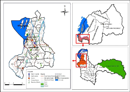
14
Source: Author, RNRA/CGIS-NUR
15
3.2. Data and material
Data availability is of prime importance when using GIS.
During this research, the main and specific objectives were achieved after
using primary and secondary data. Field observation and interview with
different District staffs in charge of environment, infrastructure and land
officer land were used as techniques to obtain primary data that were used to
complement spatial data that were used as secondary data. Systematic
exploration of written documents such as books and others was used as
documentation technique.
Spatial data for Rusizi town were collected from Rwanda
Natural Resources Authority (RNRA/Department of Lands and Mapping) through
CGIS-NUR were used to come up with a proposed suitability map for landfill site
selection.
On the other hand, different materials were also used so as to
come up with the expected result. They include:
|
>
|
DEM ( Slope)
|
>
|
Airport
|
|
>
|
Roads network
|
>
|
Market
|
|
>
|
River
|
>
|
Schools ( Primary and Secondary)
|
|
>
|
Lake
|
> Health facilities ( health centers and
|
> Forest District hospitals)
> Wetlands
3.3. Methods and techniques
The methods and techniques are research tools for data
collection, adapted at the same time for investigation, adapted for analysis
and above all from the point of view, guide the research. The methodology in
this chapter provides evidence for analysis that is utilized to determine the
optimal landfill sites. The technical approach was also employed to produce
suitability maps emphasizing «suitable» geographic areas resulting
from weighted and combined map layers based on established variables.
Methodologies used are normally based on a composite
suitability analysis using map overlays and their extension to include
statistical analysis. In this study, the approach was to utilize models that
combine and integrate maps to determine an optimal landfill siting. There are a
number of integration models in GIS.
Probably the simplest and best-known type of GIS model is
based on Boolean operation. It involves the logical combination of binary maps
resulting from applicable conditional operators. If the criteria and guidelines
are to be established as a set of deterministic rules (Constraints), this
method is a practical and easily applied approach (Dikshit, Padmavathi, &
Das, 2000). The model consists of applying Boolean operators to a set of input
maps. Each of the maps used as a condition can be thought of as a layer of
evidence. The various layers of evidence are combined to support a hypothesis,
or proposition. The output is a binary map, because each location is either
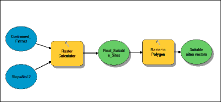
satisfactory or is not (Bonham-Carter, 1994). The following figures show model
builder that were used in this study.
Fig 3-2: Model builder for Factor Map
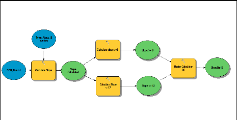
Source: Author
16
This model builder was used to produce Slope analysis Map (Fig
4-2).
Fig 3-3: Model builder for Constraints Map
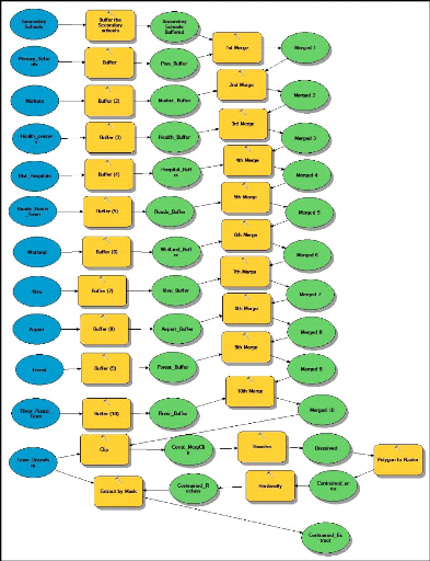
Source: Author
17
This model builder was used to produce Constraints and
Permissible Area Map (Fig 4-3).
18
Fig 3-4: Model builder for Final map
Source: Author
This model builder was used to produce Distribution of
Suitable and Potential sites Maps (Fig 4-4 and Fig 4-5).
3.4. Data Analysis and Interpretation
AGIS-based analysis was conducted using ArcGIS software,
Spatial Analyst. Spatial Analyst is a raster or grid based software package
that provides a platform for working with gridded data sets. It was used to
produce suitability maps highlighting «suitable» geographic areas
derived from weighted and combined map layers based on established criteria.
Analyzing spatial layers essentially involves setting the
study area boundary, making slope map, buffer zone maps, find distance from
water body and roads, reclassified maps and suitability maps that are presented
in Chapter 4 of this study.
Raster maps as constraints maps indicating areas, which are
suitable and not suitable for the sitting of a landfill, will be provided. The
non-suitable areas are known as buffers (Kontos, Komilis, & Halavdakis,
2003). These constraints maps include the surface water, towns, rivers, roads,
and land-use. They will also be used as factor maps representing areas that
range from low suitability to high suitability.
CHAPTER 4: WASTE GENERATION AND MANAGEMENT IN RUSIZI:
BOTLENECKS' ANALYSIS AND SUITABLE LANDFILL SITES LOCATION
This chapter presents 4 different parts: Waste generation and
management in Rusizi town, Gaps and challenges in waste management in Rusizi
town, Site selection for landfill in Rusizi town, possibilities for landfill
sites project implementation.
4.1. Waste generation and management in Rusizi Town
There are no major industries within the town of Rusizi and as
such the solid waste generated within the CBD is largely biodegradable material
from the municipal market mixed with polythene and paper products used in
packaging.
Table 4-1: Evolution of Solid waste by Sector in the Town of
Rusizi
|
Name of Sector
|
Solid waste generation ( Kg/ day) and its projections
|
|
Year 2005
|
Year 2010
|
Year 2015
|
Year 2020
|
1. Kamembe
|
13,924
|
17,770
|
22,680
|
28,946
|
2. Gihundwe A
|
4,152
|
5,299
|
6,763
|
8,631
|
3. Mururu
|
|
2,888
|
3,685
|
4,703
|
6,004
|
|
|
Grand Total
|
20,964
|
26,754
|
34,146
|
43,581
|
Source: Cyangugu Town master plan 2005-2020
Table 4-2: Composition of Waste in Rusizi Town
|
Categories
|
Components
|
|
Biodegradable waste
|
Food and kitchen waste, green waste and paper
|
|
Recyclable material
|
Glass, bottles, cans, metals and plastics
|
|
Inert waste
|
Construction and demolition waste
|
|
Electrical and electronic waste
|
TVs, computers and screens
|
|
Composite waste
|
Clothing and tetra packs
|
|
Hazardous waste
|
Paints, chemicals, light bulbs, and fertilizers
|
19
Source: Cyangugu Town master plan 2005-2020
20
4.2. Gaps and challenges in waste management in the
town of Rusizi
According to REMA, the disposal of the following wastes with
the rest of the municipal solid waste is prohibited:
? Hazardous Wastes other than those specifically authorized in
the Hazardous Waste
Regulation;
? Bulk liquids and sludge which contain free liquid;
? Liquid or semisolid wastes including septage and sewage
treatment sludge;
? Automobiles, white goods, other large metallic objects and
tires (except in the case of
where recycling options are available; and
? Biomedical waste.
Despite the separation of some kinds of municipal solid waste
as requirement of REMA, Rusizi District Leaders have set up an open dumping
site where all solid wastes are disposed. The following pictures show gaps in
waste management of different municipal solid wastes that are disposed in an
open waste dumping located in Ruganda Cell, Kamembe Sector, Rusizi District.
Fig 4-1: Rusizi Town MSW management related problems
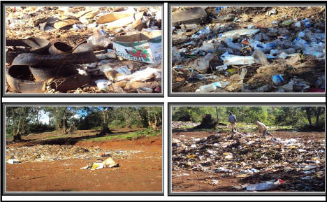
Tires and cartons dump
Dumping site located in the forest
Children in a non-fenced dump
Plastic bottles and bags dump
Source: Author
21
Table 4-3: Proportions (in %) of dwelling units according to
mode of disposal of household waste in the town of Rusizi.
|
Mode of disposal of household waste
|
%
|
|
Composting
|
51.3
|
|
Individual dust bin
|
3.9
|
|
Public dustbin
|
1.2
|
|
In the bush
|
2.7
|
|
On the farms
|
39.0
|
|
In the rivers/ streams
|
0.9
|
|
Others
|
0.9
|
|
Total
|
100
|
Source: Cyangugu Town master plan 2005-2020
According to MINIFRA, Rusizi town is facing different solid waste
management challenges
that include:
> There is no centralized garbage collection system;
> Lack of safe disposal methods;
> The municipal council collects garbage from the market and
some of the major
restaurants and institutions, and charges a nominal monthly
fee;
> Lack of designated dumping site / land fill where 50% of the
population relies on
compost pits while 40% of ordinary households on the farms;
> There is no designed garbage dumping site and most of the
garbage is deposited along
road reserves in the outskirts of the town and
> A majority dispose of garbage by burning or dumping by the
road sides.
4.3. Site selection for landfill in Rusizi Town 4.3.1.
Criteria for site selection
There are different criteria for landfill site selection, but
given the availability of data, environmental, economic and social criteria
were taken into consideration in this study.
22
4.3.1.1. Environmental criteria 4.3.1.1.1. Land
slope
(Lin & Kao, 2005) have suggested that the appropriate
slope for constructing a landfill is about 8-12% because too steep of a slope
would make it difficult to construct and maintain while too flat of a slope
would affect the runoff drainage. Slopes above 12% created high runoff rates
for precipitation. With higher runoff rate and decreased infiltration,
contaminants are able to travel greater distances from the containment area.
4.3.1.1.2. Proximity to wells and Forest
A landfill must not be located near any surface streams,
lakes, rivers, wells, or wetlands. Proximity to wells was an important
criterion to accessing the landfill site. Landfills create noxious gases and
leachate that make them unsuitable to be in proximity to water wells (Dorhofer
& Siebert, 1996). For this reason, a 300-m buffer would be placed using the
function in GIS software, which will be used to generate the buffer around all
wells and forests.
4.3.1.2. Social- economic criteria
4.3.1.2.1. Airports
Landfill sites attract variety of birds to be accumulated
around. This issue may interfere with the operation of airplanes. So it is
essential to consider suitable distance from landfill site according to airport
and airplane types (Daneshvar, 2004). By considering this criterion as a
constraint, for safety matters, 3 kilometer buffer around airport was omitted
from the next investigation.
4.3.1.2.2. Roads network
Landfill location must be close to roads network in order to
facilitate transportation and consequently to reduce relative costs. However,
aesthetically and logically a buffer of 100 meter has been considered in this
study. In other words, direct relationship between distance from roads and land
suitability is started from the 100 meter distance of roads.
4.3.1.2.3. Schools, Hospitals and Markets
By considering this as a constraint, a buffer of 01 Km will be
reserved to Primary and Secondary schools, health centers and District
hospitals, and markets (REMA, 2010).
23
4.3.2. Landfill site determination
The site selection analysis involves three steps: preliminary
analysis, multi-criteria evaluation, and identification of the most suitable
site. The preliminary analysis stage involves creating a study area map to
input the data layers, then creating permissible area map for landfill sites in
Rusizi town.
The second step involves performing GIS overlaying, which is
conducted by combining the non restricted area map and slope analysis map in
order to get the suitable landfill sites in Rusizi town that would be located
in the intersection of non restricted area and suitable slope. The final step
relates the finding of suitable sites using the information in advanced GIS and
REMA regulations regarding landfill site's size.
Non restricted area map, Slope analysis map, Potential
landfill sites in Rusizi town, Potential landfill sites in Mururu Sector,
Potential landfill sites in Gihundwe Sector and General Suitability maps were
created and produced.
24
4.3.2.1. Slope analysis
Fig 4-2: Slope analysis
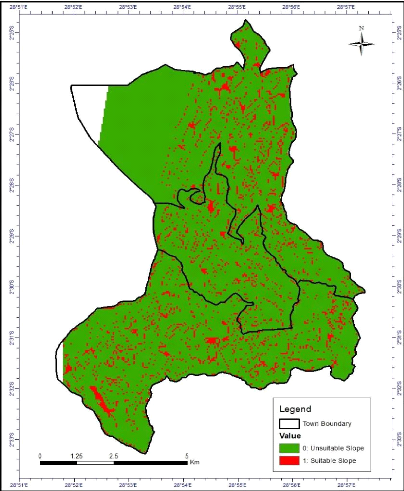
Source: Author, RNRA/CGIS-NUR
That slope map was created based on the DEM of Rusizi Town.
Using spatial analyst tools, the DEM was transformed into slope and after the
slope was classified into 2 classes using raster calculator as shown in Fig 3-2
in order to come up with the appropriate slope for constructing a landfill
which is about 8-12% because too steep of a slope would make it difficult to
construct and maintain while too flat of a slope would affect the runoff
drainage. Slopes above 12% created high runoff rates for precipitation. .
25
4.3.2.2. Constrained and permissible areas
Fig 4-3: Constrained and permissible areas
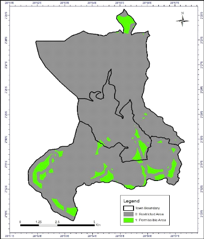
Source: Author, RNRA/CGIS-NUR
The constraint map was produced by merging each individual
theme within the study area. This procedure created a constraint map for each
theme containing only two classes (suitable land) and (unsuitable land). The 11
constraint maps (layers) namely, River, Lake, Wetland, forest, Roads, Airport,
Market, Primary schools, Secondary schools, District hospitals and Health
centers were used as shown by Fig 3-3.
26
4.3.2.3. Suitable sites in Rusizi Town
Fig 4-4: Distribution of Suitable sites in Rusizi Town
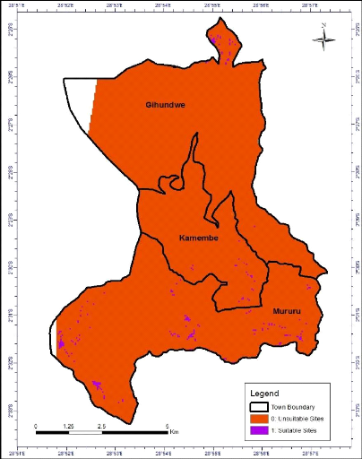
Source: Author, RNRA/CGIS-NUR
That map was created by combining the non restricted area map
and slope analysis map as shown in Fig3-4 in order to get the suitable landfill
sites in Rusizi town that would be located in the intersection of non
restricted area and suitable slope. 133 suitable landfill sites were identified
in the town of Rusizi. Their shape length area and shape area are shown in the
table 4-4 below.
27
Table 4-4: Suitable Sites and their areas (in Sqm)
|
OBJECT ID
|
Grid Cod
|
Shape
Length
|
Shape Area
|
|
OBJECT ID
|
Grid Cod
|
Shape
Length
|
Shape
Area
|
|
OBJECT ID
|
Grid Cod
|
Shape
Length
|
Shape Area
|
|
1
|
1
|
188.6
|
1711.6
|
45
|
1
|
355.0
|
5922.8
|
91
|
1
|
188.6
|
1711.6
|
|
2
|
1
|
200.0
|
2500.0
|
46
|
1
|
188.6
|
1711.6
|
92
|
1
|
187.5
|
1601.0
|
|
3
|
1
|
188.6
|
1711.6
|
47
|
1
|
283.7
|
3374.6
|
93
|
1
|
381.4
|
5010.8
|
|
4
|
1
|
200.0
|
2500.0
|
48
|
1
|
353.6
|
5867.0
|
94
|
1
|
188.6
|
1711.6
|
|
5
|
1
|
282.9
|
3413.5
|
49
|
1
|
188.6
|
1711.6
|
95
|
1
|
188.6
|
1711.6
|
|
6
|
1
|
188.6
|
1711.6
|
50
|
1
|
188.6
|
1711.6
|
96
|
1
|
355.0
|
5922.8
|
|
7
|
1
|
282.9
|
3413.5
|
51
|
1
|
188.6
|
1711.6
|
97
|
1
|
283.7
|
3374.6
|
|
8
|
1
|
188.6
|
1711.6
|
52
|
1
|
188.6
|
1711.6
|
98
|
1
|
188.6
|
1711.6
|
|
9
|
1
|
187.5
|
1601.0
|
53
|
1
|
188.6
|
1711.6
|
99
|
1
|
982.6
|
26915.3
|
|
10
|
1
|
282.9
|
3413.5
|
54
|
1
|
188.6
|
1711.6
|
100
|
1
|
188.6
|
1711.6
|
|
11
|
1
|
188.6
|
1711.6
|
55
|
1
|
188.6
|
1711.6
|
101
|
1
|
188.6
|
1711.6
|
|
12
|
1
|
841.2
|
29831.5
|
56
|
1
|
188.6
|
1711.6
|
102
|
1
|
433.8
|
11155.7
|
|
13
|
1
|
188.6
|
1711.6
|
57
|
1
|
188.6
|
1711.6
|
103
|
1
|
188.6
|
1711.6
|
|
14
|
1
|
282.9
|
3413.5
|
58
|
1
|
188.6
|
1711.6
|
104
|
1
|
188.6
|
1711.6
|
|
15
|
1
|
188.6
|
1711.6
|
59
|
1
|
188.6
|
1711.6
|
105
|
1
|
282.9
|
3413.5
|
|
16
|
1
|
188.6
|
1711.6
|
60
|
1
|
188.6
|
1711.6
|
106
|
1
|
188.6
|
1711.6
|
|
17
|
1
|
282.9
|
3413.5
|
61
|
1
|
188.6
|
1711.6
|
107
|
1
|
188.6
|
1711.6
|
|
18
|
1
|
379.4
|
5160.5
|
62
|
1
|
283.7
|
3374.6
|
108
|
1
|
188.6
|
1711.6
|
|
19
|
1
|
188.6
|
1711.6
|
63
|
1
|
188.6
|
1711.6
|
109
|
1
|
200.0
|
2500.0
|
|
20
|
1
|
353.6
|
5867.0
|
64
|
1
|
646.6
|
24024.8
|
110
|
1
|
282.9
|
3413.5
|
|
21
|
1
|
408.3
|
8280.5
|
65
|
1
|
282.9
|
3413.5
|
111
|
1
|
355.0
|
5922.8
|
|
22
|
1
|
282.9
|
3413.5
|
66
|
1
|
188.6
|
1711.6
|
112
|
1
|
400.0
|
7500.0
|
|
23
|
1
|
188.6
|
1711.6
|
67
|
1
|
188.6
|
1711.6
|
113
|
1
|
924.0
|
43540.0
|
|
24
|
1
|
188.6
|
1711.6
|
68
|
1
|
188.6
|
1711.6
|
114
|
1
|
187.5
|
1601.0
|
|
25
|
1
|
188.6
|
1711.6
|
69
|
1
|
282.9
|
3413.5
|
115
|
1
|
188.6
|
1711.7
|
|
26
|
1
|
188.6
|
1711.6
|
70
|
1
|
282.9
|
3413.5
|
116
|
1
|
200.0
|
2500.0
|
|
27
|
1
|
188.6
|
1711.6
|
71
|
1
|
188.6
|
1711.6
|
117
|
1
|
400.0
|
7500.0
|
|
28
|
1
|
188.6
|
1711.6
|
72
|
1
|
188.6
|
1711.6
|
118
|
1
|
200.0
|
2500.0
|
|
29
|
1
|
283.7
|
3374.6
|
73
|
1
|
188.6
|
1711.6
|
119
|
1
|
188.6
|
1711.7
|
|
30
|
1
|
188.6
|
1711.6
|
74
|
1
|
188.6
|
1711.6
|
120
|
1
|
188.6
|
1711.7
|
|
31
|
1
|
188.6
|
1711.6
|
75
|
1
|
188.6
|
1711.6
|
121
|
1
|
188.6
|
1711.7
|
|
32
|
1
|
188.6
|
1711.6
|
76
|
1
|
188.6
|
1711.6
|
122
|
1
|
200.0
|
2500.0
|
|
33
|
1
|
188.6
|
1711.6
|
77
|
1
|
188.6
|
1711.6
|
123
|
1
|
188.6
|
1711.7
|
|
34
|
1
|
188.6
|
1711.6
|
78
|
1
|
188.6
|
1711.6
|
124
|
1
|
282.9
|
3413.5
|
|
35
|
1
|
353.2
|
5791.9
|
79
|
1
|
188.6
|
1711.6
|
125
|
1
|
200.0
|
2500.0
|
|
36
|
1
|
188.6
|
1711.6
|
80
|
1
|
381.4
|
5010.8
|
126
|
1
|
188.6
|
1711.7
|
|
37
|
1
|
188.6
|
1711.6
|
81
|
1
|
282.9
|
3413.5
|
127
|
1
|
200.0
|
2500.0
|
|
38
|
1
|
188.6
|
1711.6
|
82
|
1
|
188.6
|
1711.6
|
128
|
1
|
271.7
|
3488.0
|
|
39
|
1
|
188.6
|
1711.6
|
83
|
1
|
188.6
|
1711.6
|
129
|
1
|
200.0
|
2500.0
|
|
40
|
1
|
188.6
|
1711.6
|
84
|
1
|
355.0
|
5922.8
|
130
|
1
|
1135.6
|
52633.1
|
|
41
|
1
|
282.9
|
3413.5
|
85
|
1
|
188.6
|
1711.6
|
131
|
1
|
188.6
|
1711.7
|
|
42
|
1
|
188.6
|
1711.6
|
86
|
1
|
188.6
|
1711.6
|
132
|
1
|
188.6
|
1711.7
|
|
43
|
1
|
188.6
|
1711.6
|
87
|
1
|
282.9
|
3413.5
|
133
|
1
|
379.4
|
5160.5
|
28
4.3.2.4. Potential landfill sites in Rusizi Town
Fig 4-5: Distribution of Potential landfill sites in Rusizi
Town
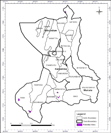
Source: Author, RNRA/CGIS-NUR
That map was created based on Distribution of suitable sites
in Rusizi Town map and REMA regulations regarding landfill site's size.
According to REMA requirement related to the size of a suitable landfill site,
05 potential landfill sites were identified because their area is greater than
20000 Sqm (2 Ha) given that the site should provide at least 10 years of use in
order to;
29
minimize costs for site establishment and closure, smooth
running of operations, and provision of adequate time for acquiring the next
site.
Table 4-5: Potential landfill sites
|
OBJECT ID
|
Grid Cod
|
Shape Length
|
Shape Area
|
|
1
|
1
|
841.2
|
29831.4
|
|
2
|
1
|
646.5
|
24024.7
|
|
3
|
1
|
982.6
|
26915.2
|
|
4
|
1
|
924.
|
43540
|
|
5
|
1
|
1135.5
|
52633.1
|
Table 4-6: Location of potential landfill sites
|
Administrative location of sites
|
Sites per Cell
|
Area (Sqm)
|
|
Sector
|
Cell
|
|
Mururu
|
Tara
|
2
|
1
|
52633.1
|
|
|
|
2
|
43540
|
|
Kabahinda
|
2
|
1
|
26915
|
|
|
|
2
|
24024,7
|
|
Gihundwe
|
Gatsiro
|
1
|
29831,4
|
|
Total
|
5
|
176944,2
|
30
Fig 4-6: General Suitability Map
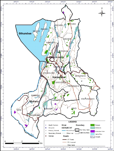
Source: Author, RNRA/CGIS-NUR
The general suitability map was created by combining potential
landfill sites map and different constraint layers including proximity to roads
(National roads, District roads, and other roads), proximity to river (Rusizi
River and other rivers), Kivu lake, wetland, forest,
31
airport, schools (primary and secondary schools), healthy
facilities (health centers and District hospitals) and markets layers.
4.4. Possibilities for landfill sites project
implementation
Landfill sites project implementation in Rusizi town can
involve different actors both private and public. After the identification of
different landfill suitable sites in Rusizi town, the public authority can
proceed on site location to find out whether there is no site that is located
in the public land so as to reduce the cost of compensation of land owners.
Given the budget constraint, landfill sites project in Rusizi town can be
implemented once they decided to use a sanitary landfill among different
landfill management techniques because sanitary landfill is the most
cost-effective system of solid waste disposal for most urban areas compared to
composting of solid waste that costs 2-3 times more than sanitary landfill, and
incineration that costs 5-10 times more (REMA 2010).
Landfill sites project implementation requires Private Sector
Involvement, if properly arranged, can increase the likelihood that landfill
design and operation specifications will be followed. Ideally, the landfill
would be designed, built, owned and operated by a private identity or NGO under
a concession agreement.
Landfill sites project implementation should be based on
environmental report that describes the site selected, outlines potential
environmental impacts of sanitary landfill at the site, and proposes mitigative
measures; public education and local consultations with residents in the
vicinity of the proposed sanitary landfill, including an open forum where all
interested parties have an opportunity to express their opinions concerning
site selection; compensation and resettlement action plans for affected
parties; and conceptual design and budgetary costing of the sanitary landfill,
including mitigative measures identified in the environmental report and
responsive to the local consultations.
CHAPTER 5: GENERAL CONCLUSION AND
RECOMMENDATIONS
5.1. General Conclusion
Locating suitable sites for any purpose (for example
industrial, landfills, and road construction or Infrastructure development
among others) is always a major challenge faced by both the government and the
private sector due to NIMBY attitudes among the communities. Landfill site
selection results are usually faced with NIMBY syndrome in every country,
because people are concerned about their property. So in site selection, the
problem is not to find sites which cause no opposition, but the goal is to find
sites which should lead to minimum conflicts as a result of waste disposal.
The main objective of this research was to identify/ show
different suitable landfill sites for municipal solid waste in Rusizi town.
Three specific objectives have been formulated in order to achieve the main
objective. The specific objectives are: to assess the current situation of
waste generation and management in Rusizi town, to determine different criteria
for selecting a landfill site in Rusizi town, and to determine suitable site
(s) for landfill for waste dumping.
To respond to these specific objectives, multi source data and
methods were used. These included the review of government rules and
regulations regarding landfill sites selection, secondary data and primary data
collected from the field. Several input data were also integrated in this
analysis. These included Airport, Digital Elevation Model, rivers, slope, Kivu
Lake, wetland, roads, schools, hospitals, markets and forests.
Objective 1: To assess the current
situation of waste generation and management in Rusizi town
To respond this specific objective, the field study was
conducted in Rusizi District and it was found out that about 26 tons of
municipal solid waste are generated per day and a small part of it is deposited
in open dumping landfill site located in Ruganda Cell, Kamembe Sector, in
Rusizi Town given that 50% of the population relies on compost pits while 40%
of ordinary households on the farms.
32
Objective 2: To assess the suitability of the
current landfill sites.
33
To achieve this specific objective, the necessary criteria
including regulations and constraints were gathered through literature review.
Regulations and constraints gathered from literature review were complemented
by field study that found out that Ruganda open dumping site was not suitable
for landfill site given that it did not fulfill the environmental, political,
economic, hydrologic, topographical and geologic criteria. Furthermore, it is
located in a forest.
Objective 3: To determine suitable site(s)
for landfill for waste dumping
To achieve this objective, GIS analysis was conducted with
respect to slope, roads network, rivers, Kivu Lake, wetlands, forest, schools,
healthy facilities, markets and airport, 131 suitable landfill sites were
produced. With reference to REMA regulations regarding to suitable landfill
size, 05 best landfill sites with more than 02 ha were identified in Rusizi
town where 04 suitable landfill sites were identified in Mururu Sector and 01
suitable landfill site was identified in Gihundwe Sector.
5.2. Recommendations
The major problem encountered during this study was lack of
some of the required data that may improve the quality of the final result.
Ground water levels of the recommended suitable sites were not measured because
of costs involved, lack of technical equipment required for that functionality,
and time. Soil types map was missing while (Sadek, El Fadel, & El Hougeiri,
2001) emphasize that in the selection of a site for MSW land-filling, special
care has to be given to the underlying foundation soil and bedrock
characteristics: geologic structure, soil type, existing fractures, and so on.
The starting point is a geologic map of the study area showing the geologic
characteristics, the chronology of a bedrock formation and lithology.
The recommendations for future urban planning and further
research are the following:
1. Establish a solid waste management structure that improves
MSW collection; transportation, treatment and disposal.
2. Conduct further studies, including a comprehensive
Environmental Impact Assessment, to establish the suitability of 04 potential
landfill sites in Mururu Sector and 01 potential site located in Gihundwe
Sector.
34
3. Launch public education and awareness campaign on safe
waste handling and disposal methods given that 50% of the population relies on
compost pits while 40% of ordinary households on the farms.
35
REFERENCES
Al-Hanbali, a., Alsaaideh, B., & Kondoh, A. (2011). Using
GIS-Based Weighted Linear Combination Analysis and Remote Sensing Techniques to
Select Optimum Solid Waste Disposal Sites within Mafraq City, Jordan.
Journal of Geographic Information System 03(04), 267-278.
Awomeso, J. A., Taiwo, A. M., Gbadebo, A. M., & Arimoro,
A. O. (2010). Waste Disposal and Pollution Management in Urban Areas: A
Workable Remedy for the Environment in Developing Countries. American
Journal of Environmental Sciences, 6(1), 26-32.
Babalola, A., & Busu, I. (2011). Selection of Landfill
Sites for Solid Waste Treatment in Damaturu Town-Using GIS Techniques.
[scientific research]. Journal of Environmental Protection,, 2,
1-10.
Bonham-Carter, G. F. (1994). Geographic Information
Systems for Geoscientists: Modelling with GIS. Oxford: Pergamon.
Chang, N., Parvathinathanb, G., & Breden, J. B. (2008).
Combining GIS with fuzzy multicriteria decision making for landfill siting in a
fast-growing urban region. Journal of Environmental Management, 87,
139-153.
Daneshvar, R. (2004). Customizing Arcmap Interface to Generate
a User- Friendly Landfill Site Selection GIS Tool. University of Ottawa.
Delgado, O. B., Mendoza, M., Granados, E. L., & Geneletti,
D. (2008). Analysis of land suitability for the siting of inter-municipal
landfills in the Cuitzeo Lake Basin, Mexico. Waste Management &
Research, 28, 1137-1146.
Dikshit, A. K., Padmavathi, T., & Das, R. K. (2000).
Locating Potential Landfill Sites Using Geographic Information Systems.
Journal of Environmental Systems, 28(1), 43-54.
Dorhofer, G., & Siebert, H. (1996). The search for
landfill sites--Requirements and implementation in Lower Saxony, Germany.
Environmental Geology, 35(1), 55-65.
Erkut, E., & Moran, S. R. (1991). Locating obnoxious
facilities in the public sector: An application of the hierarchy process to
municipal landfill siting decisions. Socio-Economic Planning Sciences,
25(2), 89-102.
36
Higgs, G. (2006). Integrating multi-criteria techniques with
geographical information systems in waste facility location to enhance public
participation. Waste Management & Research, 24, 105-117.
Kao, J. J., & Lin, H. (1996). Multifactor spatial analysis
for landfill siting. Journal of Environmental Engineering, 122(10),
902-908.
Kontos, T. D., Komilis, D. P., & Halavdakis, C. P. (2003).
Siting MSW landfills on Lesvos Island with a GIS-based methodology. Waste
Management & Research. 21(3): 262277.
Kontos, T. D., Komilis, D. P., & Halvadakis, C. P. (2003).
Siting MSW landfills on Lesvos island with a GISbased methodology. Waste
Management & Research, 21, 262-277.
Koshy, L., Emma, P., Sarah, L., Tim, J., & Kelly, B.
(2007). Bio-reactive of Leachate from Municipal Solid Waste As-sessment of
Toxicity. Science of the total Environment, 384(1-3), 177-181.
Kreith, F. (1994). Handbook of Solid Waste
Management. New York: McGraw-Hill.
Lin, H. Y., & Kao, J. J. (2005). Grid-based heuristic
method for multifactor landfill siting. Journal of Computing in Civil
Engineering, 19(4), 369-376.
Lober, D. J. (1995). Resolving the siting impasse:Modeling
social and environmental locational criteria with a geographic information
system. Journal of the American Planning Association. American Planning
Association, 61(4), 482-495.
Malczewski, J. (1997). Propagation of errors in multicriteria
location analysis: A case study. In G. Fandel & T. Gal (Eds.). Multiple
criteria decision making, 154-155.
Nakakawa, A. (2006). A Spatial Decision Support Tool for
Landfill Site Selection For Municipal Solid Waste Management. Makerere
University, Kampala.
Nas, B., Cay, T., Iscan, F., & Berktay, A. (2010).
Selection of MSW landfill site for Konya, Turkey using GIS and multi-criteria
evaluation. Environ Monit Assess, 160, 491-500.
Pandey, G. N., & Carney, G. C. (2005). Environmental
engineering. New Delhi: Tata McGraw-Hill.
Rahman, M., & Hoque, A. (2006). Site Suitability Analysis
for Solid Waste Disposal Using GIS: A Case Study on KCC Area. The Journal
of Geo-Environment, 6, 72-86.
37
REMA. (2010). Practical Tools on Solid Waste Management of
Imidugudu, Small Towns and Cities : Landfill and Composting Facilities.
RURA. (2011). STANDARDS ON THE MANAGEMENT OF WASTE
DISPOSAL SITE (LANDFILL).
Sadek, S., El Fadel, M., & El Hougeiri, N. (2001).
Optimizing Landfill Siting Through GIS Application, . Paper presented
at the Seventeenth International Conference on Solid Waste Technology and
Management,
. Sakai, S., Sawell, S. E., Chandler, A. J., Eighmy, T. T.,
Kosson, D. S., Vehlow, J., et al. (1996). World Trends in Municipal Solid Waste
Management. Waste Management, 16(5-6), 341-350.
Sener, B., Suzen, L., & Doyuran, V. (2006). Landfill site
selection by using geographic information systems. Environmental Geology,
49, 376-388.
STEPHEN, J. C. (1991). Integrating multi-criteria evaluation
with geographical information systems. International Journal of
Geographical Information Systems, 5(3), 321-339.
Tchobanoglous, G., & (1993). Integrated solid waste
management : engineering principles and management issues. New York: Mc
Graw Hill.
Tchobanoglous, G., & Kreith, F. (2002). Handbook of
Solid Waste Management. New York: McGraw-Hill.
Vatalis, K., & Manoliadis, O. (2002). A two-level
multicriteria DSS for landfill site selection using GIS: Case study in Western
Macedonia, Greece. Journal of Geographic Information and Decision
Analysis,, 6(1), 49-56.
Weigand, H., Fripan, J., Przybilla, I., & Marb, C. (2003).
IComposition and contaminant loads of household waste in Bavaria, Germany:
Investigating effects of settlement structure and waste management practice.
Paper presented at the Proc. of the 9th International Waste Management and
Landfill Symposium.
Wilson, D. G. (1977). Handbook of Solid Waste
Management. New York: Van Nostrand Reinhold Company.
| 

