CHAPTER III: PRESENTATION
OF THE RESULTS AND DISCUSSION.
At the sight of all that was presented up in
particular the importance of a hierarchisation of the lanes in urban
environment and the different categories which constitutes or should constitute
an urban space, we think that the structuring, the installation and the
adequate hierarchisation of the roadway system of a city have an impact on his
functioning. Indeed, this impact or rather these impacts is found on several
scale and aspects among which on the functioning of the aforesaid city, the
field of road safety etc.
3.1. The legibility and functionality of the plan of the
city
The YCC has a GIS exploited under
the software Mapinfo™. It is indicated on the roadway system, public
equipment, the marketing activities, the school and medical
infrastructures...
This GIS is thus a reliable source of information on the
roadway network of the town of Yaoundé. Indeed, according to its data,
the roadway network of the town of Yaoundé is estimated at 2.536
km of lanes of which 755 km are paved. Even if, part
of linear of the total roadway network of the GIS is out of the territory of
the YCC, the network of the city is being quite higher than the advanced
figures in all the municipal official documents, in particular 435 km of paved
routes and 465 km of unpaved routes.
Therefore, if we consider the whole of the roadway network of
the city, the level of coverture proposed in Yaoundé is in the average
of the developing countries. However, the covered network of the city has a
lower level of cover among to the world.
Table2: Indicators of roadway
cover of
Yaoundé
|
Indicator
|
Yaounde (total network)
|
Yaounde (covered network)
|
Developing country
|
Developed countries
|
|
Mètres/1000 inhabitants
|
1200
|
350
|
150 - 3000
|
530 - 10000
|
|
Meters/hectares
|
90 - 120
|
26 - 35
|
40 - 220
|
60 - 320
|
Source : PDU Yaoundé
The roadway network of the town of Yaoundé is arranged
hierarchically according to several types of ways. Although there do not exist
formal basic for this classification within the YCC. Wedistinguish there:
· the National roads, which are urban portions of the
national roads, long of 65 km, including 61 km paved;
· A network of 166 km of primary roadways system, of
which 159 km are paved;
· A secondary roadway system, having an overall length of
78 km, of which 57 km are paved;
· ATertiaryroadway network, of which 478 km of ways are
paved.
Table3:Hierarchisation of the highway network system
of the GIS of the town of Yaoundé
|
Classifyroadway system
|
Total (in km)
|
% of the total
|
Paved (km)
|
% Paved by Class
|
|
National roads
|
65
|
3%
|
61
|
94%
|
|
Primary
|
166
|
7%
|
159
|
96%
|
|
Secondary
|
78
|
3%
|
57
|
73%
|
|
Tertiary
|
2.227
|
88%
|
478
|
21%
|
|
Total
|
2 536
|
100%
|
755
|
30%
|
Source : PDU
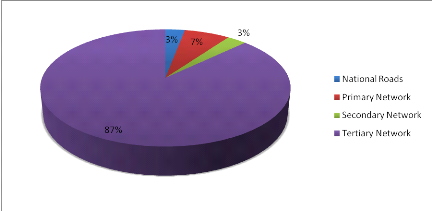
Figure 6: Repartition of
the highway network system of the town of Yaoundé
A weakness in the organization and the structuring of the
roadway network system makes it possible to highlight important dysfunctions
such:
· Problems «of use of the ways» i.e. important
loads of traffic on unsuited axes;
· Problems of grid of the network;
· Problems of legibility and marking out: because in a
badly structured space, it becomes difficult to know «spontaneously»
if we are or not on an main road, standardized crossroads and the great number
of roundabouts disturbing the comprehension of the routes network;
· Difficulties to make cohabit on the same space cars and
other alternative modes of displacements.
It thus appears essential to be concerned with hierarchisation
of the roadway network system to put in adequacy the treatment of a way and the
functions which it ensures in the network.
So, an urban space well organized must emphasize
· Ways with large transit which have as roles to direct
the national and regional transit through the city (flow which have nothing to
doin the urban perimeter but are just pass through ) just as it will have to
give access to the urban perimeter since and towards outside. The objectives of
the construction of this type of work are the fluidity and the safety of the
light vehicles and the heavy trucks, of the exchanges satisfactory with the
perimeter around. Thistype of ways has the characteristic of a highway
· Penetrating ways which have as roles in the roadway
network system, to allow an exchange between the transit ways and the internal
road network of the city. These ways have characteristics of fast tracks.
This hierarchisation brought back to the context of the town
of Yaoundé is almost the same. Thus, we distinguish four classes there;
from whose only the two first ways are regarded as being structuring ways of
the agglomeration. We have there:
· The primary Roadway system: it includes the whole of
the ways which constitute the principal grid of the urban highway network:
national roads, the principal penetrating, by-pass, ways connecting between
them principal public equipment and with the great centres of population;
· The secondary Roadway system: the secondary network of
roadway system here ensures the connection between the zones bordering located
inside the meshs on the primary distributers. Connected to the primary network
of roadway system, it supplements the structuring grid of the city;
· The tertiary Roadway system: the tertiary network is a
network of service road which makes it possible to reach in the middle of the
various districts of the city;
· Particular Roadway systems: the ways of the industrial
parks, of the zones where circulation is partially or completely prohibited,
are the subject of a classification and a specific standardization.
The current network structuring town of Yaoundé is
equipped with 270 kilometers structuring ways; is
13% of the total linear of the roadway system of the city
including 120 kilometers of primary ways and 150
kilometers of secondary roads. The current configuration of the
network shows a concentration of structuring ways in the center town area.
Indeed, the administrative center and the shopping mall are best equipped in
broad avenues and paved boulevards. Because of their localization, on one hand,
and limited number of loop lines, on the other hand, they constitute the zone
of passage of important flows of traffic.
The structuring network of the town of Yaoundé appears
being thus relatively weak. Moreover, in this classification,
10% of the total network are consisted of the primary
distributers (and national roads), against 3% for the
secondary roadway system what is rather inadequate because the primary
distributers having to be lower than the secondary roadway system.
As corollaries of this
insufficiency of the structuring network of the city, we have a saturation of
the principal access roads to the city just as it is noticed there a presence
of traffics and misfit practice sources of multiple traffic accident and a
functionality of the plan of the city which appears rather poor.
Indeed, a study of the various types of traffic having an
origin and/or an internal or external destination of the city reveals that the
inbound traffic towards outside amounts to approximately 4% of
the total traffic. Moreover, 0,4% of the counted total traffic
are a through traffic thus inappropriate because being a traffic having an
origin and an external destination at the city. This figure, in spite of that,
has to being raised to take account of the night traffic, since the trucks of
more than 20 tons, like the timber trucks, cannot circulate in Yaoundé
during the day. This through traffic can be estimated at approximately
1% of the total traffic by the night counting carried out
during the investigations. The buses and the minibuses have a ratio of exchange
close to 35%. Transport by bus ensures the service road close
to Yaoundé and that of the big cities of the country.
Table4: Distribution of the
traffics in the town of Yaoundé
|
Intern
|
Importation
|
Export
|
Transit
|
|
Motor bikes
|
94,9%
|
2,5%
|
2,5%
|
0,0%
|
|
Cars and 4X4
|
92,9%
|
3,4%
|
3,4%
|
0,3%
|
|
Taxis
|
95,3%
|
2,2%
|
2,2%
|
0,3%
|
|
Mini bus
|
65,8%
|
16,4%
|
16,4%
|
1,4%
|
|
Bus
|
62,8%
|
17,9%
|
17,9%
|
1,4%
|
|
Van
|
88,8%
|
5,5%
|
5,5%
|
0,2%
|
|
Trucks (=2 axles)
|
78,4%
|
9,8%
|
9,8%
|
2,0%
|
|
Trucks (  2 axles) 2 axles)
|
77,8%
|
11,1%
|
11,1%
|
0,0%
|
|
Trailers
|
100%
|
0,0%
|
0,0%
|
0,0%
|
Source : PDU
3,9%
Moreover, the GIS of the YUC provide information on the state
of 267 kilometersof ways. Thus, even if more than
90% of this linear is judged in a good or average state, it
should be recalled that the analysis related only to 11% of
the total highway network and 72% of the structuring
network.
Table5: State of the road in the town of
Yaoundé according to the GIS of the YCC
|
Class of ways
|
Good
|
Means
|
Bad
|
In the course of work
|
Total
|
% analyzed by class of ways
|
|
National roads
|
44
|
4
|
0
|
0
|
48
|
74%
|
|
Primary
|
107
|
14
|
4
|
3
|
129
|
78%
|
|
Secondary
|
30
|
9
|
6
|
0
|
45
|
57%
|
|
Tertiary
|
21
|
16
|
6
|
1
|
44
|
2%
|
|
Total
|
202
|
45
|
16
|
4
|
267
|
11%
|
Another study carried out by
ECTA-BTP in 2006 fact the point on the state of the structuring network of the
city. This study aimed to work out a multiannual program of maintenance of the
priority roadway system of Yaoundé and related to 281 kilometers of
«structuring» ways, mainly paved. Three criteria of synthetic
qualification of the state of the sections were given for the needs for the
study:
· «Good» if degraded surface is lower or equal
to 10% of the entire surface of the section;
· «Average» if degraded surface lies between 10
and 30% of the entire surface of the section;
· «Bad» if degraded surface is higher than 30%
of the entire surface of the section.
The results of this analysis are deferred in the table
hereafter.
Table6: State of the priority
ways of Yaoundé in 2006
|
State
|
Roadway
|
Dependences of the roadway
|
Cleansing
|
Lighting
|
Indication/safety
|
|
Good
|
75%
|
34%
|
42%
|
32%
|
7%
|
|
Means
|
17%
|
15%
|
11%
|
2%
|
1%
|
|
Bad
|
8%
|
47%
|
43%
|
62%
|
89%
|
|
No value
|
0%
|
4%
|
3%
|
3%
|
3%
|
|
Total
|
100%
|
100%
|
100%
|
100%
|
100%
|
Source : PDU
If the state of the roadways is described as «good»
in 75% of the cases, the other elements were often recognized
«bad», in particular the lighting, the street signs and safety.
It is to note efforts which are made in the direction of the
resolution of these various failures in particular through constructions of
various penetrating ways and of skirting which will make it possible to better
manage the through traffics in the town of Yaoundé.
| 

