Will ASECNA meet the needs of african air navigation for the 21st century? an analysis of asecna strategy for adopting CNS/ATM( Télécharger le fichier original )par Francis NTONGO Cranfield college of aeronautics - MSc Air Transport Management 2005 |

4.7 ConclusionThis chapter has allowed us to present the basic components of CNS/ATM systems. How the proposed CNS/ATM technologies work, and how they actually deliver the expected benefits to ASECNA has been studied. The study shows that the systems are suitable to ASECNA as trials indicate that they could respond to its characteristics and its problems. Satellite based navigation, data communication, and improved radar surveillance, will render air traffic management much more efficient. Future communication and satellite-based technologies will allow better exchanges between pilots and controllers on both continental and oceanic airspaces. Trials presented have shown that CPDLC, relying on high bit rates and more capacitive data link techniques such as VDL, Mode S and satellite communication reduces communication errors and reduce voice channels saturation and interferences. This 18 Before the airline's bankruptcy means a safer communication environment. As controllers and pilots will loose less time in unnecessary communications, this will have a positive effect on airspace capacity, and increase safety margins. Moreover, controllers' workload will significantly been reduced, particularly in areas where traffic is relatively dense, which will improve productivity and cost effectiveness in peak periods. In areas where traffic is less dense, the new system will not have a significant impact, as controllers' workload is already very low. At last, ATN will improve the quality, the speed and the integrity of data transmission between users and service providers Satellite navigation, in providing more navigation accuracy in conjunction with augmentation systems, will allow aircraft to flight efficient trajectories and make a better use of airspace with less dispersion, potentially avoiding diversion cost in bad visibility conditions. Secondary airports will be accessed without the need of landing aids. RNAV, RVSM, and RNP will increase route efficiency, safety, and capacity. New surveillance technologies performance during trials (ADS, Radar Mode S) show that aircraft detection and identification are improved in remote areas such as oceans or deserts, and allow ANSPs to deliver a safer service at a significantly lower acquisition and operating cost. Big air operators are fitting their fleet with these capabilities. Small carriers will not have the means to upgrade their old fleet. ASECNA has to adapt to each category's particular needs. At last, transition between the old and the new system requires cooperation between the different stakeholders. To ensure a smooth shift in technologies, interoperability between the systems is essential. Chapter 5: Analysis of ASECNA's Modernisation Strategy The aim of this chapter is to present and analyse ASECNA's modernisation strategy, for each CNS/ATM component. 5.1 Description 5.1.1 Communications ASECNA's objective is the full deployment of an ATN environment with the possibility to accommodate FANS1/A and the highest degree of functionality possible. Fixed Network: ASECNA has embarked in the modernization of AFTN by high-speed links and in the integration of its telecommunication systems. The Interconnection of sub-regional communication networks and the setting up of an independent satellite digital telecommunication network within its area, for AFTN and mobile communications needs and for exchanges of meteorological data to assist ATM are being implemented. Data Communication: The use of secured and efficient protocols is expected to increase end-to-end reliability of data transmission. A Flight data automation program is engaged: The FIR Antananarivo already has FDPS, CPDLC and ADS-C capabilities. Trials for similar systems and testing of a VDL sub-network and HFDL are being conducted in Dakar. VHF coverage: The VHF coverage programme is well advanced. Plans suggest that almost all ASECNA's routes will be covered and controlled by means of VHF radio, except the Oceanic FIR. VHF has been deported to Agades, Zinder, Tessalit, GAO, Dirkou (FIR Niamey- Areas of Routing 3-4-9), Faya-Largeau (FIR N'Djamena AR-3) by means of VSAT stations. Others are being implemented in Bir Moghrein, Nema, Taoudennit, Tombouctou, Nouadhbou (FIR Dakar continental, AR 1-9), Moroni, Toamassima, Tolangnaro (FIR Antananarivo,AR-10), Sao Tome and Principe, Bria, Makokou and Pointe Noire (FIR Brazzaville, AR-4-5). A program to modernise VHF and HF Chapter 5: Analysis of ASECNA's Modernisation Strategy equipments and installation of VSAT TS Direct speech facilities in other places are also on the way. 5.1.2 Navigation Successful flight trials in May 2005 from Dakar to Nairobi have been conducted, using EGNOS. These followed other trials in West and Central Africa, conducted in February 2003 in Dakar, Senegal and in June 2003 at many airports of the States of Central Africa (Nigeria, Cameroon, Gabon and Equatorial Guinea). GNSS approach procedures are already available for all major airports in ASECNA. As it is necessary to maintain adequate navigation service during the transition period, ASECNA has launched a program to replace Navaids (VOR, ILS, and DME...) in certain locations before the full implementation of GNSS. The use of satellite technologies has allowed the Agency to implement 21 RNAV routes over its upper airspace since 2004. RVSM are already implemented in Antananarivo, Brazzaville, Dakar, N'djamena and Niamey's Flight Information Regions in accordance with ICAO regional agreements. Since the beginning of 2006, operators wishing to penetrate this airspace received RVSM aircraft airworthiness and operational approval from the appropriate state authority. 5.1.3 Surveillance Voice position reports remain the dominant procedure. However in high and medium traffic density terminals and approach areas, SSR will be required while ADS will be progressively introduced. ADS/CPDLC Antananarivo's and N'djamena's FIRs have already implemented ADS/CPDLC. ASECNA was the first to develop ground equipments in the AFI region for the ADS. It served to demonstrate the potential advantages of ADS displays in the AFI region. These were the first ADS trials on the continental scale. Chapter 5: Analysis of ASECNA's Modernisation Strategy As part of a surveillance exercise, ASECNA is currently carrying out ADS/CPDLC trials in Dakar. Implementation plan (2001-2005) provides for the installation of ADS systems in Dakar and in Sal Island (cap Verde) to monitor the oceanic FIRs. These systems have screen displays capabilities in order to monitor the aircraft position at the control centres. The display technologies used are:
The system will use CPDLC data exchanged between pilots and controllers to automatically update corresponding flight plans. Trials were still on-going in June 2005. But regulatory and normalisation requirements slow the decision process. Radar Mode S It is planned to install 5 Monopulse SSR mode S radars with full ADS/CPDLC capabilities in N'djamena, Dakar, Niamey, Brazzaville. Abidjan's radar is already operational. They should all be operational within 2 years (2007). Trials are being conducted in N'djamena, Dakar and Brazzaville. The new system will be able to manage at least 17 airspace sectors simultaneously, and will permanently be monitored by 12 controllers, including optional positions, instead of 5 today. A total of 24 to 30 controllers, forming teams of 4 to 5 people, will be trained in that purpose. Other surveillance projects include multilateration surveillance systems at Bir Moghreim, Taoudenit, Tessalit, Agadez Bria, and Faya Largeau. Chapter 5: Analysis of ASECNA's Modernisation Strategy 5.1.4 On-board the aircraft The aircraft of major international airlines linking Africa to Europe are already equipped with built-in onboard CNS/ATM systems. Aircraft only flying national or sub-regional routes are equipped with RNAV-1 systems and autopilot. A low-cost CNS/ATM system composed of a VHF data link, an ADS mode and GNSS for navigation is added to it. Communications and ADS surveillance benefit from VHF cover and ATM automation on the ground. These aircraft are to be equipped with a C-mode transponder for surveillance radar requirements in some terminal regions. The design approach for the configuration of avionics is modular, to allow the evolution from one ATM level to another. 5.1.5 Aviation weather To better meet the airline demands, ASECNA is integrating the requirements expressed via IATA into its equipment plans. Over the period 2000-2006, ASECNA has strengthened the capacities of its meteorological centres by making the following major investments:
These systems have not all been implemented yet, but the process is well advanced. ASECNA is progressively migrating onto the Second Generation Weather Satellites (MSG), with greater capacity of data processing (Flight planning dossiers, Turbulence, Obstacle...etc) (Ndobian Kitagoto, Met Engineer, ASECNA). Chapter 5: Analysis of ASECNA's Modernisation Strategy 5.1.6 Air Traffic Management ASECNA's ATM Concept is primarily instituted between airports rather than gate-togate1. Departure/arrival management will be implemented through SIDs and STARs and not through fully integrated management like in ECAC for instance. The airspace will offer some flexibility sizing capability, whereas ECAC will implement a dynamic flight-to-flight adjustment. The agency has also planned to offer its users their preferred routes within the filed flight plans, with some collaborative decision-making between aircrew and controller using ADS/CPDLC, instead of free flight with autonomous operations. Three dimensional RNAV based on GNSS and RNP has been preferred to full autonomous aircraft with airborne conflict avoidance and separation assurance. Under an agreement with the ATM systems manufacturer Thalès, EUROCAT2 air traffic management system is being installed in Dakar (Senegal), Abidjan (Ivory Coast), Brazzaville (Congo) and in Niamey (Niger). The EUROCAT advanced air traffic management system provides safe and efficient operations in high density, complex airspace. Its operational displays, radar networks and flight plan processing comply fully with ICAO standards requirements. It integrates radar, ADS-C, CPDLC and ADS-B surveillance facilities for the management of traffic over oceanic and large continental areas. It will provide area and approach air traffic control. There will be a combined total of 28 working positions across all four centres which will provide controllers with advanced flight plan and radar processing, and the capability for several centres within a FIR to use a common and centralised database for improved co-ordination between centres and for sharing and handing over of flight information, search for and resolution of conflicts, flexible and dynamic track processing and ATN interface and Flight data link service, especially for aeronautical weather. 1 Gate to Gate operational concept is based on better collaboration between ATM actors and better planning to enhance the exchange of accurate and reliable data, resulting into increased capacity and safety (Hugo de Jong & Marc Soumirant, june,1st,2004). 2 The Eurocat air traffic management system is a highly integrated air traffic management system, currently used operationally in more than 100 flight information regions. To date, 130 EUROCAT air traffic management systems, in multiple configurations, have been purchased by more than 50 civil aviation authorities all over the world. Chapter 5: Analysis of ASECNA's Modernisation Strategy Airspace rationalisation Within the framework of airspace rationalisation and controls extension, ASECNA, plans to create 2 sectors within the upper airspace (>FL 245) in the Dakar continental FIR, and integrate the existing UTAs. The long term objective of ASECNA is to reform ATM procedures by reducing the number of number of UIRs (upper flight data regions) and the number of FIRs and control centres, harmonizing TMA limits and integrating of sub-regional ATM systems. RVSM In order to increase its airspace capacity, ASECNA has implemented RVSM in parts of its airspace. RSVM implementation3 in ASECNA's area comes after what was done in the Oceanic FIR, and in the EUR/SAM corridor. 5.1.7 Cooperation Technical aspects ASECNA is cooperating with its neighbours within the framework of ICAO's CNS/ATM regional planning. Technical cooperation includes telecommunications, and some aspects of airspace rationalisation. Main cooperation activities are done with ENNA (Etablissement National de la Navigation Aerienne, Algerian ANSP) and SADC (South African Development Cooperation) led by ATNS. In the light of the drawbacks in the interface and the experience acquired, ASECNA and ENNA have established an efficient and viable co-operation framework that could enable them to carry out their mission of ensuring the security and regularity of air traffic more efficiently. A master plan establishing a framework of cooperation has been established since 2000. The aim of the master plan for coordination and harmonisation context, is to tackle the scope and diversity of the problems caused by the extension of the FIR interface under ASECNA and ENNA management, the shortcomings in terms of communications, the volume of air traffic today and the 3 Between FL 290 and Fl 410 included. RVSM will be implemented with the upper lateral limits of the following UIRs: Antananarivo, Brazzaville, Dakar continental, Dakar Oceanic, N'djamena, Niamey, and SAL oceanic. Chapter 5: Analysis of ASECNA's Modernisation Strategy envisioned growth, the application of the new ICAO civil aviation navigation system. Ultimate goals are better coordination and harmonisation aiming at: harmonising working procedures and methods; creating air routes; harmonising their means of coordination; joint use of technical equipment; co-ordinating development activities and exchanging information, particularly, with regard to CNS/ATM systems and the exchange of personnel. Considered as the appropriate framework for promoting the security and regularity of air traffic, this plan which conforms to the ICAO recommendations will make it possible to homogenise the levels of performance of the two systems. Cooperation with SADC is well advanced. The interconnection of the SADC and ASECNA VSAT networks allows Johannesburg to communicate with Congo Brazzaville and Madagascar (Antananarivo) through the AFISNET4 network whilst Antananarivo communicates with Beira (Mozambique) and Dar es Salaam (Tanzania) through the SADC network. In ensuring a balanced solution, ATNS installed a SADC terminal in Antananarivo and ASECNA installed the AFISNET terminal in Johannesburg. The agency has migrated on Intelsat 10.02 with Nigeria, Ghana, and other neighbouring Airspaces. It's waiting for the others (CAFSAT, SADC) to join them on the same satellite transponder. Cooperation with Nigeria is very limited as this country has just started to build a viable air navigation system. Nigerian Airspace Management agency (NAMA) was created in 2000 following the Kenya Airways Airbus crash off the coast of Cote d'Ivoire, killing 69 Nigerians on board, after it could not land in Lagos due to poor visibility and the unavailability of instruments landing systems. The Agency has since launched an ambitious modernisation programme and is cooperating with ASECNA 4 In view of the difficulty of developing a network on a landline infrastructure, the AFISNET West Africa sub-network is the first slice of this AFISNET aeronautical network developed by ASECNA. It is based on the installation of Earth stations sited directly on the major operating sites (airports, VHF remote antenna). The Earth stations of Bangui, Brazzaville, Douala, Libreville, and N'djamena have been in service since April 1995. The Dakar and Abidjan Earth stations have been in service since 1996. ASECNA operates and maintains the oldest and largest international satellite network dedicated to the needs of air navigation. The AFISNET network is composed of about fifty Earth stations, grouped into two sub-networks: Chapter 5: Analysis of ASECNA's Modernisation Strategy which calibrates its Navaids equipments. Nevertheless, Nigerian airspace is developed to meet domestic requirements. Like in ASECNA, EUROCAT systems have already been planned elsewhere across Africa including Nigeria, Sudan, Algeria, Egypt, South Africa and Mauritius. By implementing similar systems each ANSP can benefit from a greater regional interoperability and enhances the continent's air safety. As ASECNA is the most advanced form of air navigation integration, it's calling for the others to adopt its model, in order to deliver a seamless airspace. The concept of «single African sky» ASECNA and ATNS (South Africa Service Provider) jointly hosted African air navigation service providers in Senegal in 2002 to discuss the challenges facing air navigation in the region. The focus was on the benefits of regional service provision to reduce duplication of services, the importance of the interoperability of systems, as well as a continued drive for the commercialisation of air navigation service providers to ensure that aviation revenue is reinvested into aviation (ATNS, 20002). Within that framework, in 2003, in Yaoundé, Cameroon, ASECNA and other African service providers agreed that the concept of a single African sky should be a long term objective that needs to be studied. It should be the result of a gradual process comprising the following steps: 1 Harmonisation of ATM systems and procedures, including training programs. 2 Rationalisation of service areas 3 Cross boundaries cooperation between ANSPs 4 Consolidation if necessary of air navigation services, based on costs-benefits, the elimination of discontinuities, and the necessity of a flexible system taking into account the users needs. Chapter 5: Analysis of ASECNA's Modernisation Strategy 5.1.8 Training Seminar/workshops to raise awareness about CNS/ATM techniques are provided in the region. ASECNA has introduced courses on the new systems into the training programme for engineers and technicians in its training centres, with the participation of the ICAO's TRAINAIR programme (established to encourage states to use standardised training methodology, and develop international training systems sharing). An air traffic management training centre for air traffic controllers will be installed at ASECNA's training school (EAMAC) in Niamey. Fitted with an ATM simulator, it will significantly increase ASECNA's ability to train its controllers and permits ASECNA to standardise its training procedures and the qualification of its controllers. In order to improve the quality of its services, ASECNA considerably increased its training budget between 1998 and 2004 to meet the shortage of technical staff and put the required number of staff in place. During that period, the number of technical staff increased from 781 to 1,116 graduates. ASECNA has already trained controllers for the introduction of RVSM although it is not implemented yet. 5.1.9 Financing The principle of funding of the business case is that the planned CNS/ATM technologies for ASECNA are economically viable investments with adequate financial returns for both ASECNA and airlines. The life cycle of the investment is assumed to be 15 years. The total capital investment in this case can be fully recovered through the provision of user charges. The result of this analysis indicates a life cycle net present value (NPV5) (i.e. present value revenues minus present value costs) of $23.5 million. The payback period, the point at which cumulative revenues equals cumulative expenses would be 12 years from the implementation of the plan. Both CNS/ATM and current ground-based systems were assumed to operate in parallel during this phase of the implementation. 5 The NPV approach requires predictions of the future profiles of the annual costs and benefits associated with the implementation of CNS/ATM systems. Once all the year-by-year expenditure and benefits are established, the net benefit (benefit minus cost) for each year are calculated and discounted back to the base year in accordance with standard accounting practices. Chapter 5: Analysis of ASECNA's Modernisation Strategy Sources of Financing ASECNA has signed financing convention with different financial institutions worldwide and Political Organizations. These include the European Bank of Investment, the African Development Fund, The West African Development Bank, The Central African Bank of Development, The European Union and others. CNS/ATM demonstrations and tests are generally self-financed and sometimes financed by subsidies from these financing structures. For the actual implementation of the system, the agency's usual financers (mainly European and African) indicate that they are ready to deal with and continue the adventure with ASECNA in upgrading its equipment to the next generation. Cost effectiveness sequencing ASECNA's current charging policy is as follows: Charge for use of en-route facilities and services managed by the agency are payable whatever are the conditions in which the flight is accomplished (IFR or VFR) and whatever are the departure and the destination aerodrome. Charging varies depending on the nature of the flight (national, regional, international) and the weight of the aircraft. However, these incremental costs (A in the Figure 5.1) are unique to CNS/ATM systems, and would not be incurred if the systems were not implemented (ICAO, 1995). In this later case, incremental expenditures on present technology would be required in order to continue operating the existing system (B in Figure 5.1). These would be avoided if CNS/ATM is fully implemented. Substantial annual expenditures are common to current and future systems (C in Figure 5.1). These expenditures would be incurred even if CNS/ATM is implemented. CNS/ATM costs also comprise conversion costs (D in the Figure 5.1). In the case of ASECNA, agency will have to pass these incremental costs to users as said previously. This means that charges will progressively increase during the life cycle of the investment (15 years), in order to reconcile current and future revenues and capital expenditure. The investment program amounts for about $276 million dollars from 1995 to 2010 (235 up to 2005). Assuming that a proportionate investment will be consented during the following ten years, and that current and future systems coexist, users will have to bear 225 million $US from 2005 to 2020, that is to say 16.5 million dollars per year if a margin of 10 % is taken into account. ASECNA collected about 170 Chapter 5: Analysis of ASECNA's Modernisation Strategy million dollars in 2004. This means that the navigation charges could potentially increased by 9.7 per cent per year over the period6. Figure 5.1: Classification of Costs
Cost Existing CNS/ATM C B D A C Source: ICAO, 1995 5.1.10 ASECNA's implementation schedule up to 2015 ? Step 1: 2005 to 2010 - Progressive removal of ground based systems that are necessary to FANS systems: HF, NDBs, VORs, DMEs, ACARS, ILS/MLS Cat 1, Radioborne... etc. - Progressive introduction of CNS/ATM systems - Participation to the end of global transition plan ? Step 2: 2010 to 2015 - Transition completed and FANS systems are unique to be operated. The plan will be updated according to the technologies available 6 The payback period may be different, and probably lesser, which will increase the annual rate Chapter 5: Analysis of ASECNA's Modernisation Strategy ASECNA is slightly late in its implementation plans. The removal of ground based Navaids has not started. The Agency is even reinforcing ground based navigation in some countries. However, this is consistent with the pace of global implementation. 5.2 Analysis The strategy depicted above clearly shows that ASECNA is aiming at tackling three operational aspects: Safety, Efficiency and Capacity. These objectives are in line with the industry's requirements that have been identified and defined earlier. In fact, the agency is fully implementing ICAO's CNS/ATM transition guidelines. ASECNA's high level strategic goal appears to be the consolidation and the modernisation of existing systems, getting the future ready by gradually introducing CNS/ATM systems that interoperate with the conventional means, in order to be operational when these systems will be fully required. For Communications, the strategy is to extend VHF coverage along international major traffic flows and inhospitable areas. The modernisation of the telecommunication network infrastructure and systems through digitalisation is a step towards greater data transmission and processing accuracy, efficiency and capacity. Recent deregulation of the telecommunication markets in the region is what allows ASECNA to implement suitable systems for its operations. For Navigation, the agency aims at ensuring the good maintenance of existing means during the transition phase, establishing tests beds and technological survey for satellite based navigation, and carrying-on the implementation of WG-84 coordinates. Once completely introduced, satellite navigation will also be used in remote airports that actually lack instrument landing means. It potentially concerns 76 secondary airports. Depending on the quality of ground infrastructures, and the availability of practicable runways, this will increase their availability for operations, and could create potentials for air travel growth. Introducing RVSM in its airspace, the agency is permitting homogenous navigation areas between EUR CAR/SAM, ASIA/PAC and ASECNA. More than 90 per cent of Western airlines' aircraft will be fitted with RNP and RNAV Chapter 5: Analysis of ASECNA's Modernisation Strategy capabilities (as mentioned earlier in Chapter 4) by the beginning of next decade, whereas local airlines could not have the means to upgrade their old fleet to that level. Hence, ASECNA is adopting a modular approach by setting up flexible ATM systems that will be able to cope with multiple aircraft navigation capabilities. By initiating ADS-B trials for the Atlantic Antananarivo and Dakar's FIRs, the agency is anticipating traffic characteristics in the EUR/SAM corridor and the Indian Ocean. This dual strategy will certainly respond to both the needs of large and small airlines, but this is questionable, as it is clear that it could not be cost-efficient. The fleet of certain national and sub-regional aircraft operators is heterogeneous, and they have limited means. There are greatest concerns about their capacity to respect the transition schedule. A well organized transition is costly in terms of regulations, installation, testing and training for all of the means, on the ground and onboard. Badly organized transition is even more expensive: maintaining dual ground and onboard installations, delay in receipt of benefits. Equally questionable is the ability of the agency's strategy to deliver a fully efficient navigation system. In fact, the strategy does not suggest a desire to totally cover the airspace, but only the most frequented routes. The rigid routes structure being maintained, it's obvious that the benefits that could be derived from RNP and ADS capabilities will significantly be limited in the continental airspace. For Surveillance, ASECNA's strategy is to progressively install modern surveillance technologies such as SSR-Mode S and ADS/CPDLC in each one of its ACC and where they are mostly needed for safety reasons. For ATM, airspace rationalisation and cross boundaries operational harmonisation of rules and procedures are the agency's ultimate aims. But rationalisation is oriented towards navigation efficiency rather than capacity in term of saturation. Cooperation with other ANSPs is limited to technical collaboration and local operational cooperation. Airspace redesign, as suggested by the project of a single African Sky, similar to what is being studied in Europe through the Single European Sky initiative (Functional Airspace Blocks) is probably for the very far term. Chapter 5: Analysis of ASECNA's Modernisation Strategy For Weather, the plans are to follow technology evolution and to adapt the infrastructure accordingly. Finally, the pan African organization intends to finance its strategy through loans from international finance establishments and appear to have the financial backing to reach objectives. Figure 5.2: Possible airspace redesign in 2030
Source: CANSO, 2005 The geographical distribution of new air navigation means suggests that the agency is not anticipating a substantial growth of air travel domestic markets for the short or medium term. City-pairs market is insignificant (as explained chapter 1) mainly between Central and Western Africa. Moreover, local airlines have no interest in operating these non profitable routes, and prefer to operate the gulf of guinea corridor to improve their load factor. Therefore ASECNA's strategy to concentrate on main regional and trans-regional corridors actually responds to both local and western airlines' needs. 5.3 Conclusion ASECNA's strategy is coherent with the region's needs. The dual strategy perfectly responds to the requirement to accommodate both big and small airlines. But the cost effectiveness of this plan is questionable: Maintaining dual equipments is costly, and will certainly impact users' charges. Chapter 5: Analysis of ASECNA's Modernisation Strategy Dakar's ADS system programme is two years late for example and Brazzaville's Radar project is also late. It is difficult to predict whether or not the Agency will fully respect its schedule. The success depends on many factors that are not directly under its control. Partly because the implementation of new air traffic concepts requires that member states update their legislations, which is often a long and slow process. Moreover the lack of means in local airlines, and the high cost of upgrading their equipments also add to the uncertainty. It is doubtful that CNS/ATM systems will have been fully implemented by all stakeholders in ASECNA by 2010. However, the time frame is similar to those of other countries worldwide, and the implementation process is more or less at the same stage as other regions like Asia. ASECNA is even more advanced than areas like Europe on some aspects of the programme such as airspace integration since its airspace is already integrated. Chapter 6: Recommendations and Conclusion The primary objective of the thesis was to analyse the state of Air Navigation in ASECNA area in order to find out regional needs and priorities, which responds to the first research question. The study found that the needs are as follows.
The secondary objective of the thesis was to study CNS/ATM technologies and their relevance to ASECNA region. It responds to the second research question. Based on the region's geographic characteristics, and its needs presented above, the study found that the new systems brings better efficient, increases safety margins and capacity, enhances data processing, and allows the extension of services. They will be cost effective on the long term, as they will help to curb the maintenance costs, and reduce airspace fragmentation as their implementation requires international cooperation, and a substantial level of operational and technical harmonisation on the continental level. The third objective was to analyse ASECNA's on-going modernisation strategy, to assess whether it will respond to the needs and the priorities highlighted. It responds to the third research question. The agency has technical objectives to improve the current system, and to implement future air navigation systems. Some systems have already been installed, and others are progressively being made available to users. But the agency is confronted to the need to accommodate both small and big carriers which do not have common interests. Given the predominance of foreign carriers and the necessity to assist local airlines to help maintaining an acceptable level of air service within the region, ASECNA has decided to put in place evolutionary new systems, allowing each type of carriers to upgrade its fleet with regard to their means and their operations. However, the segmentation of the agencies operating revenues being overwhelmingly in favour of transcontinental activities, the agency has chosen to firstly and progressively equip strategic areas of routing with CNS/ATM systems and concepts. That responds to profitability imperatives. But it does not address the immediate safety concerns all over its areas of responsibility particularly in remote regions. The agency is not prioritising domestic markets where most accidents occur as most of conventional systems are maintained there. The airspace reorganisation process that is taking place will certainly reduce unit costs. The introduction of new systems is also expected to reduce maintenance costs. But no study measuring the economic impact of newly introduced systems is available for the time being. The users will have to bear the costly equipment upgrade, and will be passed the totality of costs of acquiring, installing and operating CNS/ATM systems. In addition, the fact that the agency is maintaining a dual system will inflate costs. The agency has planned to increase navigation charges by 10 per cent increase per year. That is not a cost effective sequencing given the general state of the airline industry. In particular, navigation charges should not inflate as the result of the introduction of new systems because it could have a negative impact on the local airline industry. Recent agreements between the agency and IATA that have frozen navigation charges during the past three years suggest that ASECNA is reconsidering its charging strategy. It shows that the agency has adopted a pragmatic policy in the interest of its users. Despite limited delays in the implementation process, ASECNA has already done a huge work to modernize its infrastructure and its procedures. Its strong financial situation and the support of local governments and international financial institutions guarantee that the agency will not lack means to carry on its programmes. However, the slowness and the variability of legislation procedures and the fragmentation of regulation authorities could generate additional delays. A key point in reaching its objectives is how ASECNA will collaborate with states and civil aviation authorities to speed up the process. Moreover, experts doubt that small local airlines will be able to respect the schedule, which will delay the moment of benefits. Actually, the question is not whether ASECNA will be able to deliver a modernised service and infrastructure to match the needs; its local users and regional authorities constitute the real threat to the programme. The agency has a solid training policy, and is training air navigation staff in its own schools to prepare the future and respond to the growing demand. That long term human resource strategy guarantees the availability of sufficient skilled staff. The agency cooperates with neighbouring air navigation service providers within the framework of ICAO's modernisation plans. A certain level of technical integration has already been reached, in particular between ASECNA and South Africa. As the agency is a leader in term of airspace integration on the continent, it's coordinating harmonization efforts. To conclude, and in response to the main research question, it can be stated that the ability of ASECNA to meet the needs of African Air navigation the 21st will depend on the following key factors:
ASECNA can help the Airline Industry reducing its costs through technology advances. But will it be substantial? In fact, deep structural changes are required in airlines' management practices in Africa. These necessary reforms, together with a real liberalisation, could secure a consistent growth. Nevertheless, even deep structural changes could only have limited impact if the demand side is not dealt with appropriately. High air travel taxation is a common practice in the region. States should revise that policy in the interest of economies. Given that the programme is already well advanced, and taking into account the fact that ASECNA's top management is committed to modernize the agency, and to keep its reputation as a leading and exemplary institution in Africa, it is highly probable that the Pan African institution will make adequate technologies available to its users, although there is no assurance that the time frame will be met. Whether states and air carriers will be able to fulfil their obligations in term of regulations and equipments modernisation remains uncertain. There are clear indications that they will not. Limitations and Suggestions for further research The contribution of this research was to give the reader an insight of an African region rarely studied, and one of its leading organisations that tries despite numerous environmental and structural constraints, to conduct a sound and successful strategy towards modernisation. However the work has several limitations. Many real-world problems were simplified or ignored because their solutions were outside the scope of this research. Particularly, political interferences in the management of the agency, non-harmonised civil aviation regulations together with intrinsic social and cultural characteristics that definitely influence the agency's performances, are examples of research studies that could be conducted by future students. However in a context of globalization and liberalization, studying the impact of an hypothetic privatisation of ASECNA on the quality of service would be a good contribution. References
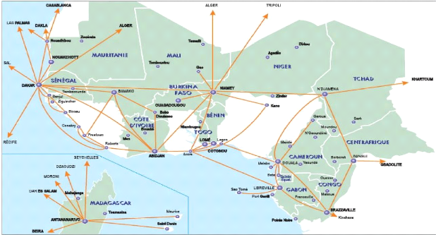
APPENDIX 1: Presentation of ASECNA History: An example of inter-African and Malgasy cooperation «L'Agence pour la Sécurité et la navigation aérienne en Afrique et a Madagascar» (ASECNA) was founded in 1959, in Senegal. It is a multinational organization, created by 16 African countries1, 14 from Western and Central Africa, plus Madagascar, and France. The group was joined by the Comorian Union in 2004. The agency is presented as the best example of North to South cooperation, as well as the structure for civil aviation excellence. ASECNA has managed to last more than half a century because it adapted itself to the political economic context. When it was created, ASECNA was mainly a cooperation organisation between France and African French speaking countries and Madagascar. But years after it was founded, the Malgasy and inter-African cooperation become Predominant. This transformation was translated in the facts, by the transfer of the Agency's head quarter from Paris to Dakar, and by the «Africanisation» of the management. In 1974, the Dakar convention was signed by the 15 countries (All the current members states, without Equatorial Guinea who joined the organisation in 1987). The Dakar convention remains opened to integrate any candidate country. Mission: Air Navigation safety ASECNA is governed by the Dakar convention, and essentially exercises community activities in accordance with article number 2; but it also manages national aeronautical activities, on a purely subsidiary basis, on the behalf of some individual states and other organizations. 1 Benin, Burkina Faso, Cameroon, Central African Republic, Chad, Comores, Congo, Equatorial Guinea, Ivory Cost, Gabon, Madagascar, Mali, Mauritania, Niger, Senegal, Togo. Community activities The agency controls an area 1.5 as large as Europe. This area is divided into 6 Flight Information Regions (FIRs): Antananarivo, Brazzaville, Dakar Oceanic, Dakar Terrestrial, Niamey, and N'Djamena2. It ensures the Control of air navigation flows, aircraft guidance, the transmission of technical and traffic messages, airborne information. It also gathers data, forecasts and transmits aviation weather information. Theses services are applied for both en route, terminal approach and landing phases of the flights. ASECNA ensures terminal approach aids for the 25 main airports3 of the region, as well as 76 secondary airports. This includes airports control, approach control, ground aircraft guidance and movements, as well as radio aids and fire protection services. For these reasons, ASECNA has the responsibility to maintain the equipments necessary to deliver these services, a part from the runways. National activities Articles 10 and 12 of the Dakar Convention allow member states to entrust ASECNA to manage, maintain and the install of aeronautical infrastructures. Benin, Burkina, Central African Republic, Gabon, Equatorial Guinea, Mali, Senegal and Chad signed specific contracts with the organization under article 10. 2 These cities are respectively the capitals of the following countries: Madagascar, Congo, Senegal, Niger and Chad. The Senegalese FIR is divided into an Oceanic FIR and a terrestrial FIR. 3 Douala, Port Gentil, Mahajanga, Garoua, Malabo, Bamako, Bangui, Ouagadougou, Gao, Brazzaville, Bobo-Diolasso, Niamey, Pointe Noire, Nouakchottt, Dakar, Abidjan, Nouadhibou, N'djamena, Cotonou, Toamasina, Sarh, Libreville, Ivato, Lome. Organisation and functioning Statutory structures The Committee of
Organization Chart The Committee of Ministers, composed of member states' transport or aviation ministers defines the general policy of the agency. It meets at least once a year. The Presidency of the committee is revolving on an annual basis, which constitute a problem to the efficiency of the agency. The Board of Directors takes necessary measures to ensure the well functioning of the organization. But above all, it appoints the accounting agent, the commissioners for accounts verification, and the financial controller. External representations In Each member state, the missions of the agency are ensured by a local representation, organised as follows: Representative Air Navigation Operations Radio Electrical Infrastructure Administration and Finances Aviation Weather Civil Engineering Infrastructure Payment services External representations organization chart The agency also has two delegations, one in Paris, and the other in Montreal; The one in Paris (DELP) ensures essentially missions for the general direction: - Links with aviation administrations, airlines, international organizations; - Air Navigation fees collection - Aeronautical information edition - Purchase and routing of equipments The one in Montreal represents the agency in ICAO. The delegate is member of the international organisation air navigation commission. He participates to the work of the air navigation experts group, and has permanent links with the ASECNA's member states delegations in ICAO. Financial ASECNA resources are essentially derived from:
Since January 1st 1998, geographic coordinates (latitude and longitude) are published in term of WGS-84 geodetic reference system. Geographic coordinate obtained through conversion to the WGS-84 system but for which the degree of original accuracy measured in the field does not meet the specifications of Annex 11 and Annex 14, are pointed out by an asterisk. The degree of accuracy required for civil aviation is determined as given in Annex 11.
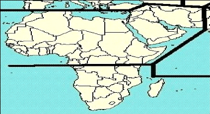
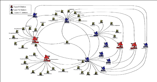
Appendix 4: ASECNA'S Telecommunications Network
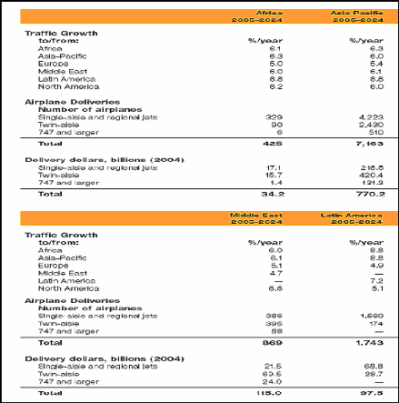
Source: Boeing 2005 outlook Appendix 5: Air Traffic Projected Growth by world region
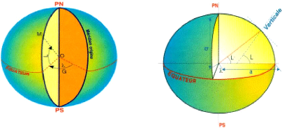
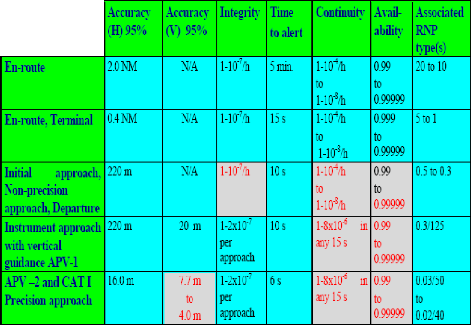
Appendix 6 : ICAO's Navigation SARPs
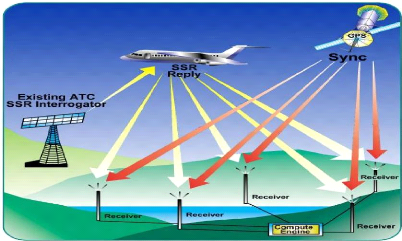
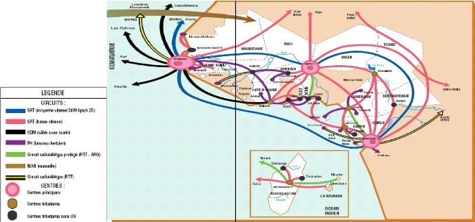
Appendix 7: ASECNA's Satellite Navigation Circuits
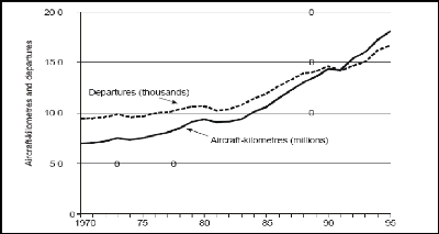
Appendix 8 ASECNA'S ATS/Direct Speech Network APPENDIX 9: Introduction to CNS/ATM Systems Drivers and Origins Background The air transport industry has grown dramatically and rapidly, more than other industries during the last two decades of the 20th century according to ICAO. The organization's statistics show that from 1985 to 1995, world air passenger travel and air freight respectively grew at an average annual pace of 5 and 7.6 per cent (ICAO, 2002). The annual variations worldwide are shown by the figure below. The number of aircraft departures gained almost 45 per cent from 1970 to 1995. A projected annual increase in traffic between 1992 and 2010 estimated that traffic would increase by about 2.5 per cent in North America, more 4 per cent in Europe, and 6 per cent in Asia, with the rest of the world following the same trend (Gallotti , 1999).
Annual Changes in scheduled aircraft movements
worldwide The picture below of a congested airspace best suggests how close some parts of the world are to the gridlock. In some parts of Europe and North America, traffic is restrained to preserve safety margins. Delays are growing, and this is hitting aircraft operators' bottom lines. On some days in the summer of 1999 European air traffic was near to collapse. According to airlines' representatives, delays have never been so bad, at least not since 1959 (Spaeth, 1999, Para 2). IATA recently estimates that delays in Europe have an annual cost of US$1.5 billion and 15 million minutes of unnecessary flight.
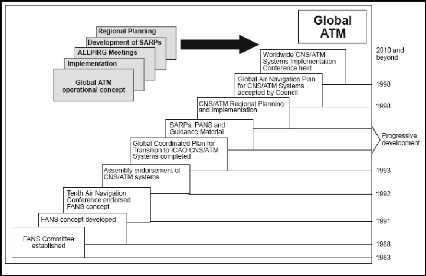
instant traffic situation display over the US airspace. Source: FAA, 2002 Elsewhere, in remote areas and over oceans, considerable improvements to ANS are required, as the current technology has limitations. These are discussed in the next chapter. ICAO's Global Implementation Plan and Monitoring FANS Committees Work Having considered the steady growth of international civil aviation before 1983, and taking into account the projected growth at that time, the council of ICAO determined in 1983 that conventional air navigation systems and procedures that were supporting civil aviation were approaching their limits, and that time had come to develop new approaches that will better suite modern air transport exigencies. In that purpose, it established a Special Committee on Future Air Navigation Systems (So called FANS committee). In 1989, the FANS committee concluded that new systems had to be developed to meet the pace of air transport development worldwide. It had also established that the shortcomings of conventional systems could have a negative impact on the development of air navigation almost anywhere. It also recognised that the new systems' objectives should be to provide a cost-effective and efficient system adaptable to all type of operations in as near four-dimensional freedom (space and time) as their capability would permit. The committee recommended that this had to be done at a global scale. In the wake of these conclusions, the ICAO council established a committee in charge the monitoring and coordination of Development and transition planning for FANS (So Called FANS committee II). Tenth Air Navigation Conference In 1991, the ICAO's tenth Air Navigation Conference (AN-Conf/10 endorsed the FANS concept, as proposed by the ad-hoc committees. The Conference concluded (Recommendation 1/1 - Endorsement of the global ATM operational concept) that ICAO, the States and the regional planning and implementation groups (PIRGs) consider the global ATM operational concept as the common global framework to guide planning for implementation of ATM systems and to focus all ATM work development. Theses concepts eventually came to be known as the CNS/ATM systems. In 1993, FANS II committee concluded that the implementation of these new technologies, and their expected benefits had to be gradual. This meant that an action plan was needed, in order to progress toward implementation of CNS/ATM technologies and systems. The emphasized was put on the important role states and the regions had to play, through PIRGs, with regard to the planning and implementation processes. The Planned evolution of the process is as shown on the following figure.
Evolution of CNS ATM implementation. Source: ICAO, 2002 The regional planning process The regional planning process is ICAO's main planning and implementation tool. A top down approach is used, comprising a global guidance and regional harmonization measures. This converges with the bottom-up approach formed by states and aircraft operators and their proposals for implementation options. Organizational and financial issues The organizational and financial aspects in the implementation process of CNS/ATM systems are the major challenges for the civil aviation community. Many CNS/ATM systems are characterised by a multinational dimension, which requires an international cooperation. Developed states have the means to finance and develop their
national CNS/ATM - Needs assessments and project development - Transition planning - Financing arrangements - Systems planning, specification, procurement, installation and commissioning - Human resource planning and development. Legal issues The legal framework that governs the conduct of service providers and users is the Chicago Convention and its annexes. Many concerns are about the Global Navigation satellite (GNSS) that shall be compatible with international law, including the Chicago Convention, its annexes and all the relevant rules applicable to outer space activities. Particularly, universal access to GNSS services without discrimination, the preservation of states sovereignty, authority and responsibility. Aircraft operators and providers of air navigation services rely on foreign systems, as the current GNSS facilities are controlled by one or several states (USA, EU, Russian Federation). The continuity of GNSS services is also a matter of concern among the community, as the state provider could decide to stop them, and force the users to rely on inefficient conventional backup systems. Appendix 10: Evolution of controllers Workforce from 2006 to 2011 in ASECNA
(c)Cranfield University 2005. All rights reserved. No part of
this publication may be |
| |||||||||||||||||||||||||||||||||||||||||||||||||||||||||||||||||||||||||||||||||||||||||||||||||||||||||||||||||||||||||||||||||||||||||||||||||||||||||||||||||||||||||||||||||||||||||||||||||||||||||||||||||||||||||||||||||||||||||||||||||||