Environmental impacts on lake Azué௠in Haiti due to degradation of its watershed( Télécharger le fichier original )par Jodany FORTUNE University of Puerto Rico - 2011 |

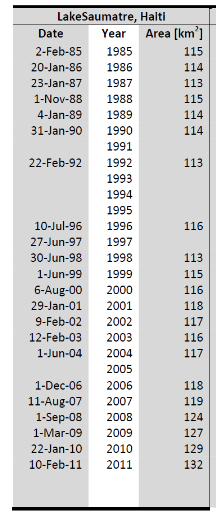
3.5 HydrologyLake Azuei is supplied in its periphery by 39 water sources of karstic origin. In the North, nine of these sources have a total average flow of 647 l / s. In the South there are sources that the average flow is between 94 l/ s and 140 l / s. It is reported that several sources are underwater. The water level of the lake varies with the rainy season and hurricane activity. In 1954, after Hurricane Hazel, the lake level rose and then returned to normal within the eight months that followed. The lake level has been exceeded on numerous occasions during the 1979-83 period with a storm rising water level of 2 meters above the current level (Thorbjarnason, 1984). But since 2007, there has been a dramatic increase in water level in Lake Azuei. 3.6 Surface Area and Lake Elevation ChangeThe surface area of the Lake Azuei fluctuates between 113 to 118 km2 from 1985 to 2002. Surface area of Lake Azuei has increased about 15% from 1985 levels. After 2003, experienced a clear increasing trend of surface area increase with Lake Azuei, reaching an area of 132 km2 in 2011 (Table I and Graph II). In Lake Azuei, the larger rate of surface area increase since 2007 may be related to water levels reaching lower sloping areas in the northwestern part in the lake.
Lake Azuei
Table I: Time Series of Lake Area Change for Lake Azuei : Romero and Poteau , 2011
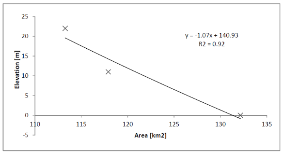
Graph II: Area vs. Elevation: Lake Azuei (Romero and Poteau, 2011) 2(*) 3.7 Major threats to management of freshwater ecosystems in Haiti (Ministere de l'Environnement : MDE, 2001)Threats to management of freshwater ecosystems in Haiti can be divided into two categories: Direct threats and indirect threats. a. Direct threats Over exploitation of the forest resources and erosion of drainage basins. Forests have been steadily exploited as wood for construction, as a source of energy ( 71% of the consumption) and as an expendable resource in the clearing of land for agriculture development. Deforestation is the major cause of erosion and the most crucial environmental concern of the nation. At present, of the thirty (30) major watersheds within the country, twenty five (25) are completely deforested (MDE, 1999). The forest cover was reduced from 60 % in 1960 to 6.7 % in 1978 (USAID, 1986). It has been estimated that the percent of the country remained forested represents less than 3% of the land surface today. The removal of vegetative cover negatively impacted freshwater ecosystems in Haiti by decreasing their capacities for sustained production. Non forested land use activities placed at risk the continued availability of reliable sources of domestic water, created general denudation of the landscape and increased erosional potential of upper water areas (MDE, 2001). b. Indirect threats They involve socio-economic and institutional factors: Ø The accelerated population growth coupled with increasing rate of poverty and uncontrolled urbanization process (shanty town): The Haitian population will reach 16 million by 2040 according to projections of the `'Secretairerie d'Etat à la Population''and as already stated the GNP per capita is $US 250, the lowest GNP in the western hemisphere (MDE, 2001). Ø The lack of application of existing laws and land use control measures to fully protect upper water catchment against illegal squatting and land clearing; Ø The lack of application, up to now, of existing policy in domestic water and its integration into a `'Schéma National d'Aménagement du Territoire'' and decision making; Ø The lack, up to now, of official strategy and action plans for critical wetlands of the country. * 2 In this case the authors want to establish the relationship between the lake surface increase and the depth (24-25 m). It's like pours some water in a conic recipient, the depth increases by adding water that increases also surface. |
|