3.1 Description of the Study Area and Experimental
Site 3.1.1 Geographical Location
Njombé covers a surface area of about 260
km2 and is located between latitudes 4°30`N and 4°40`N and
longitudes 9°30`E and 9°45`E. The average altitude of the area is 140
m. Njombé is bounded:
· to the North by Penja,
· to the South by Mbanga,
· to the West by Tombel,
· and to the East by the Nkam.
Figure 3.1 provides the geographical location of Njombé
while Figure 3.2 shows the area cultivated.
PHP group cultivates bananas and pineapples on a surface area
of about 3 500 ha and is divided into plantations, with one of them being the
Njombé plantation. These plantations in Njombé are an integral
part of the zone of production of PHP. In 2004, the cultivated land was about
2250 ha (Boa, 2005). The plantations are further divided into sectors and the
sectors into production plots.
3.1.2 Relief
Njombé has a relatively flat topography, made up of
plateaus and some eroded undulating landscape. One could notice the effects of
an old volcanic activity in the area (Tchiadje 1995).
3.1.3 Hydrology
The area has numerous water bodies and most of them are
exploited by the companies present in the area such as PHP, Tangui, SPM and by
the peasants for their day-to day activities. The principal water bodies are:
the Moungo, Moulinkam, Moumbé, Bwale, Mbomé, and Ngomba.
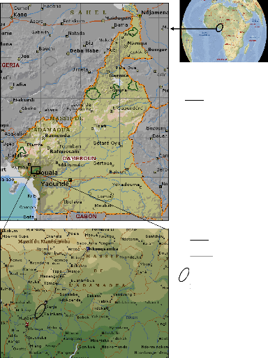
Scale :
1/20000000 Source : Encarta 2008
Scale :
1/1000000 Source : Encarta 2008
PHP plantations
Figure 3.1: Geographical location of
Njombé
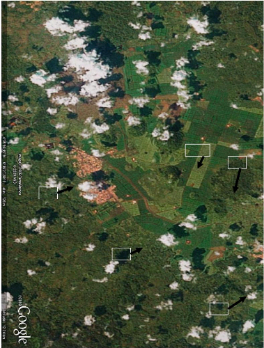
N
R
B
KEY
C
C: Hill
P
B: PHP cultivation
plots
P: Penja town
R: National road n°2
N: Njombe town Scale: 1/14000 Source: Google Earth version 5
Figure 3.2: Aerial view of PHP cultivation areas in the
Njombé Plantations
3.1.5 Vegetation
Njombé is situated in the Guineo - Congolese floristic
region, in the dense humid forest sector of the biafran forest. This forest
constitutes plants of the Cesalpiniaceae family. Some of the most
characteristic trees species found in the area are: Bidou (Saccaglottis
gabonensis) and Azobe (Lophira alata) (Van de
Pol et al, 2005). Due to the high fertility of soils in this area, there has
been serious deforestation for the setting up of either large plantations or
small farms or for the building of houses due to rapid urbanization.
Nevertheless, one could still notice some forest reserves rich in timber and
other forest species.
3.1.6 Climate
The climate of the area is equatorial with a long rainy season
which runs from March to November and a short dry season which runs from
November to February. It is a hot and humid climate with temperatures of
25-30°C and an average relative humidity of 80%. The cumulative average
annual potential evapotranspiration equals 1 055.6mm (an average weekly ETo of
20.3mm) while the annual rainfall averages about 2550mm (Thome, 2007). Table
3.1 shows the average annual precipitation of Njombé for a 5 year period
(2004-2008).
Table 3.1: Average annual precipitation of Njombé
(2004-2008)
|
Year
|
Precipitation (mm)
|
|
2004
|
2320
|
|
2005
|
2385
|
|
2006
|
2445
|
|
2007
|
2960
|
|
2008
|
2636
|
|
Mean
|
2550
|
Source: Climatic data from PHP meteorological
stations
Figure 3.3 shows the ombrothermic graph for Njombé area
for the year 2008. The graph shows the rainfall amounts and evapotranspiration
for the area for each week of the year and could be used to determine the start
and the end of the rainy and dry seasons. The peak of the rainfall lies between
the 26th and 29th month and almost zero from the
47th week to the 8th week of the year.
Figure 3.3: Monthly rainfall histogram
for Njombé in 2008 3.1.7 Soils
The soils in the area are mostly ferralitic in nature. These
are shallow soils with a clayey-sand granulometry. The pH of these soils varies
between 4.5 and 6.5. They are thus very fertile soils, rich in mineral content.
According to Defo and Marie, (1998), the soils in the banana areas of the
Moungo which are of volcanic origin have undergone several studies. These
studies have helped to distinguish with respect to the level of weathering of
the bedding rock. We could thus distinguish three types of soils:
1) Recent soils: These are andosols dominated by allophones.
These soils are characterized by a high porosity, a llight silty texture, a
fragile granular structure and an important number of stones.
2)
Soils dominated by Halloysites: These soils have a silty-clay
texture with a
ETP (m)
stable granular structure.
m
3) Highly weathered soils: These soils are dominated by
halloysites and kaolinite. They are thus soils with high clay content and thus
possess drainage problems.
| 

