Télédétection du manteau neigeux et modélisation de la contribution des eaux de fonte des neiges aux débits des oueds du haut atlas de Marrakech( Télécharger le fichier original )par Abdelghani Boudhar Université Cadi Ayyad - Doctorat National 2009 |

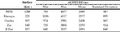
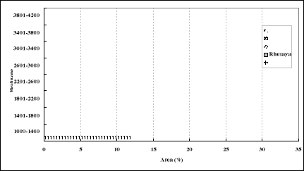
· IntroductionIn most arid and semi arid regions of the world, water resources are limited, and under severe and increasing pressure due to expanding needs for populations, tourism, industry and agriculture. Water resources are also affected by any succession of droughts. Several very dry years have been observed in the Mediterranean region over the last decade, and their frequency could increase due to climate change (Ceballos-Barbancho et al., 2008). In these regions, mountains may obviously play an important role in the regional water balance (Flerchinger & Cooley, 2000; Khazaei et al., 2003; Pitlick 1994; Viviroli et al., 2003), but the contribution of snow and rain to the annual and multi-annual water balance is still largely unknown. This is the case in the centre of Morocco, where the High-Atlas mountain range represents the most important water storage for the neighbouring arid plains through liquid but also solid precipitation (Matthews, 1989, Chaponniere et al., 2005; Boudhar et al., 2007). Snowfall usually occurs from November to May at altitudes above 1400m, but the snow cover is rarely continuous: snow can fall and melt within one week. However, in the highest parts of the High Atlas range, snow is stored during several weeks to several months. High melting rates contribute to baseflow from late winter to early summer, which can be beneficial to the agriculture. Remote sensing observations are particularly useful for providing spatially distributed input data for snowmelt runoff modelling (e.g. Dozier, 1989; Matson, 1991; Hall et al., 2002), and, in particular, snow cover areas in the High-Atlas mountains (Hanich et al., 2003; Chaponnière et al., 2005; Leroux, 2006; Boudhar et al., 2007). However, current satellites do not acquire cloud free images with a satisfying (optimally, daily) frequency, especially in mountainous regions where cloudiness is generally high. In order to compensate for the lack of continuity in remote sensing observations, additional information about snow state variables can be obtained from land surface models that are forced with surface meteorological (precipitation, air temperature and humidity, wind) and radiative variables (downward solar and longwave radiation). Ideally, a system that optimally combines snow information from both remote sensing observations and modelling predictions and at the same time accounts for the limitations of each should provide estimates that are superior to those derived from either models or remote sensing alone. This method is commonly known as data assimilation (McLaughlin, 1995). Data assimilation is a way to integrate data from a variety of sources with different resolutions and accuracies with model prediction to improve deterministic model accuracy (McLaughlin et al., 2005). It has been applied in hydrology with increasing frequency in recent years. Data assimilation is used not only to update the hydrological model states that optimally combine model outputs with observation, but also to quantify observational and hydrological model errors. Various data assimilation techniques are used in hydrologic application. Brasnett (1999) used statistical interpolation to assimilate global synoptic snow depth observations into a simple snow accumulation/snowmelt model. Sun et al. (2004) used an extended Kalman filter to assimilate synthetically generated snow water equivalent observations into a catchment-based land surface model. Andreadis & Lettenmaier (2006) assimilated snow cover area (SCA) estimates derived from the MODIS sensor as well as snow depth derived from the AMSR sensor into a macroscale hydrological model. Clark et al. (2006) also used SCA observations as part of an ensemble Kalman filter to modify the statistical distribution of snow in a mountainous watershed. They applied a simple, lumped snowpack/water-balance model and carried out synthetic experiments that showed that SCA assimilation does not result in significative improvement of simulated streamflow. However, they acknowledge that «satellite SCA information will be most useful in basins where snow cover is ephemeral», which is the case in the High Atlas range. The most widely used model designed to integrate SCA information directly as an input is the Snowmelt Runoff Model (SRM, Martinec et al., 1975). This approach is equivalent to the «direct insertion» method and is very efficient when model errors are larger than observation errors. Most other approaches simulate SCA and, when a satellite observation is available, they readjust the Snow Water Equivalent (SWE) to minimize the difference between simulated and observed SCA by mean of a Kalman Filter (Clark et al., 2006, Slater & Clark., 2006) or a variational assimilation scheme (Seo et al., 2003). Between two image acquisitions, they simulate the evolution of the snowpack with a snowfall/snowmelt model that uses detailed distributed meteorological data. These approaches are rather difficult to implement and perform accurately in well instrumented catchments where observation and model errors have comparable orders of magnitude. For most mountainous regions, partly due to accessibility constraints, rainfall/snowfall and other meteorological information are often lacking, especially in the highest parts of the catchments. It is the case in the High Atlas range where most of the meteorological stations, which measure routinely only bulk precipitation and air temperature, are located close to the catchment's outlet. The more complex models and assimilation methods are likely to fail or underperform in such poorly instrumented environments. This explains why many operational streamflow forecasting methods favour the simple and robust SRM model as well as the direct insertion method. Of course, driving models such as SRM with good SCA estimates remains a challenge in mountainous regions where spatially distributed climatic data is lacking and where remote sensing data cannot be acquired with a sufficient temporal resolution. In this context, the first objective of this paper is to compare snow cover area estimated by remote sensing and simulated by spatially interpolated meteorological data. The second objective is to test the performance of the SRM model for five sub-catchments of the High Atlas range during the years 2002-2005 and to study the impact of choosing either of the two SCA estimation methods on this performance: (1) snow depletion curves obtained from a temporal interpolation of SPOT-VEGETATION SCA estimates, and (2) a snowfall/snowmelt degree day model forced with spatially interpolated meteorological data. VI.2 Study areaThe study area takes place in the Tensift watershed in central Morocco ( Figure ýII ). This watershed covers 20 450 km2 and is composed by three parts: the northern `Jbilet' hills, the `Haouz' plain and the northern side of the high Atlas mountain range. The Tensift wadi flows sporadically from east to west and is supplied mainly from the basin's south bank: the Atlas north hillsides. The High-Atlas is mainly composed by metamorphic and eruptive formations, which are impervious and generate overland flow. Some pervious zones are still present, due to calcareous and marly sandstone formations or local weathering of the impervious formations. These pervious zones are probably responsible for an additional delay in lateral subsurface flow. The Atlas's relief is very sharp with steep slopes. Land cover consists in sparse trees below 2000m above sea level (coniferous and juniper), and bare rocks above. Soils are almost non-existent on the slopes because of high erosion rates. In the very narrow valleys, where the eroded sediments accumulate, deeper soils are present on which crops are grown. This mountain range, about 800 km long and 60 km wide, is oriented NE-SW. The highest peak in the region is the Jbel Toubkal (4167 metres above mean sea level), the highest summit of North Africa. The High Atlas range is the region's water tower, supplying several big irrigated areas in the surrounding plains of Haouz in the north, as well as Souss, Drâa and Dades in the south. In these regions, more than 85% of the available water is used by agriculture. Located in the surroundings of Marrakech city ( Figure ýII ), the Tensift watershed was intensively monitored as a pilot site of the SUDMED program (Chehbouni et al., 2008). The annual rainfall ranges from around 150 mm in the driest part of the plain to about 800 mm in the mountain. Both rain and snow are very irregular in time and space. There is no glacier in the area; therefore meltwater originates totally from snow. The main five tributary sub-catchments of the Tensift watershed are located at south and east of the Marrakech city, between latitudes 30°87 ' to 31°66' North and longitudes 22°7 'to 8°67' West. They form the southern boundary of the Tensift basin. They are from West to East: Nfis, Rheraya, Ourika, Zat and R'Dat ( Figure ýII ). To run the SRM model, the sub-catchments were subdivided into eight elevation zones. This partition was done using a Digital Elevation Model (DEM) at 90m spatial resolution provided by the Shuttle Radar Topography Mission (SRTM) after an 11-day mission in February of 2000. Figure ýVI illustrates the hypsometric variation of the study area and the main geographic characteristics of each sub-catchment are summarized in Table ýVI . The eight 400m elevation bands of Figure ýVI are chosen as individual hydrological response units for the SRM model. Relevant climatic input data will thus be required for each of these bands. The sub-catchments can be classified in two groups: basins with high altitudes (Ourika and Rheraya) and basins with lower elevations (Nfis, Zat and R'Dat).
Table ýVI- : Geographic characteristics of the study sub-catchments.
Figure ýVI-: Hypsometric variations for the five study sub-catchments. |
|