4.2. Determinants of
Communities' Vulnerability to Floods
4.2.1. Flood Frequency and Magnitude Analysis
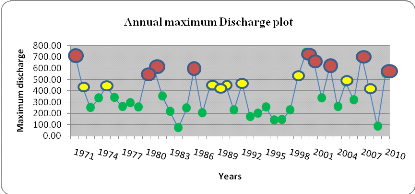
The maximum instantaneous flow of 736.70 m3/s was
recorded at Athieme during the 1999/ 2000 hydrological year while the lowest
flood flow of 69.16m3/s was recorded in 1983/1984 hydrological year.
The 40-years mean instantaneous maximum flood flow is 372.34m3/s
with a CV of 40.6% and a standard variate of 182.757m3/s "table
5". The coefficient of variation was applied to measure the consistency and the
steepness for the frequency curves in the river flow data. The CV value
obtained indicated that the distribution of flood flows was not highly
variable.
Table 5: Annual Maximum
flow basic statistics
|
Basic statistics
|
Values
|
|
Mean
|
372.34
|
|
Maximum
|
736.70
|
|
Minimum
|
69.16
|
|
Std. Deviation
|
182.757
|
|
Coef. of Variation (CV)
|
0.491
|
|
Skewness
|
0.406
|
The return period and the probability of occurrence for each
observation of the Mono River have been computed, using Weibull's formula, for
the period 1971- 2010 which generally starts to peak in the month of July with
the maximum in the month of September. according to flood hydrology data of
Athieme station.
The Mono River discharge at the downstream reveals that
the study area has been affected 22 times by low intensity flood with return
periods of 1 or 2 years with high probability of occurrence. The low intensity
is ranged between (69.16-372.33m3/s). The study area experienced
nine times moderate intensity flood with return period of 2, 3 or 4 years with
probability of occurrence less than 50% and magnitude between (372.34-549.64
m3/s). The study area was challenged with high flood event nine
times ranging between (549.65-736.70 m3/s) "figure 18" and "table
6".
The latest more severe flood for the downstream part of the
Mono basin is the one that occurred in 2010. Its return period is 5 years and
the probability of occurrence of the 2010 flood (as a same magnitude) would be
once in five years (Probability=0.22) "annexe 5". During the period, the
recurrence interval of high flood based on the 2010 flood magnitude has ranged
from 5 to 41 years. There are eight recurrence intervals covering a total
period of 40 years between the first and the last occurrence of high flood
events.
Low hazard
High Hazard
Moderate hazard
|
Discharge
|
Frequency
|
Magnitude of flood
|
|
549.65-736.70
|
9
|
High
|
|
372.34-549.64
|
9
|
Moderate
|
|
69.16-372.33
|
22
|
Low
|
Figure 12:Flood Frequency
and Flood Magnitude
4.2.2 Flood Duration and Flood Water Level
Assessment
The water level as well as flood duration were
different for the targeted villages "table 7". The result reveals that the
higher the flood water level, the higher the flood duration.
It was noticed that villages such as Kpodji,
Tchakponou and Logokpo have the highest flood level and highest flood duration
although they are the most distant of the Mono River. This can be explained by
the fact that these villages are surrounded by Mono River's sub-branches. They
are not directly inundated by the Mono river itself but rather by the Mono's
sub-branches. Then, when water comes from all the sub-branches, the total areas
is highly inundated. In addition, the area is made up by heavy soil which can
decrease the flood water infiltration capacity and increase the duration of
flood water in the area.What about the soil types in the affected
villages?????
Table 6: Depths of flood
water (2010) as revealed by marks on building walls and average flood duration
(2010) from household
|
Flooded areas
|
Depth of flood marks on walls (2010)
|
Proximity to the river body (m)
|
Flood duration (days) (2010)
|
|
Djrekpon
|
63- 99cm
|
470.35
|
58
|
|
Batoe
|
50-118 cm
|
303.79
|
82
|
|
Logokpo
|
70-100cm
|
909.28
|
88
|
|
Tchakponou
|
50-106cm
|
626.13
|
80
|
|
Kpodji
|
57-170 cm
|
1874.22
|
95
|
|
Tofacope
|
30-45cm
|
112.54
|
41
|
|
Atikpatafo
|
65- 70 cm
|
165.55
|
71
|
|
Mawussou
|
45-65cm
|
435.55
|
51
|
In addition, all the eight surveyed villages lie in
the low altitude level of the Yoto district comprised between (12-58m) which
makes them to be highly exposed to flood hazards "Map 2".
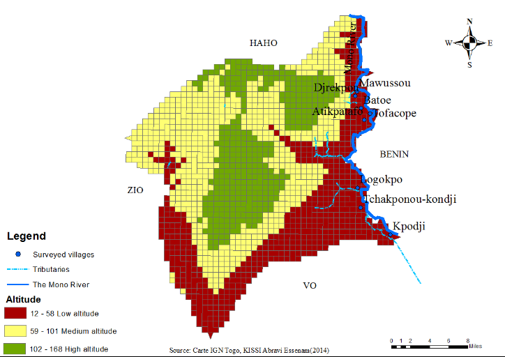
Map 2: Map of Yoto district
showing the surveyed villages in low altitude
4.2.3. Elements at Risks
The study focuses on two main elements at risks: households and
their agriculture croplands. The total population from the surveyed sample is
about 2124 composed of children, young, elderly, and adult. 42.74% of the total
population are children, 4.61% are elderly and 17.14% are women. As it is shown
in various studies and confirmed by the majority of the respondents 72.36%,
women, children and elderly are considered as the most exposed to flood due to
their fragility. The little high proportion of children under 15 years in the
study area may increase the communities' vulnerability to flood disasters.
Based on information collected through the simple random survey,
it was found that those surveyed households were having agriculture croplands
of about 506 ha of which the majority is very closer to the river body (less or
equal to 200m). The crop production activity in the study area depends on
rainfall and practices which is still traditional with rudimentary tools.
Farmers are faced with problems of storage and preservation of harvested crops.
Thus, when flood came, before and even after harvesting period, the majority of
crops are destroyed.
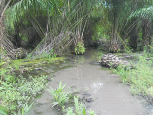
Photo 1: Oil palm farm under water since the 2010
flood, Photograph taken during field work
| 

