CHAPTER TWO
2.0 OVERVIEW OF THE STUDY AREA
2.1 The Study Area
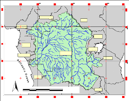
The study area comprises The Congo River Basin, bounded
between Latitude 100 and 150S and between longitude
100 and 350 degree East (Figure 1). This area covers
several countries in Africa: Democratic Republic of the Congo (DRC), the
People's Republic of the Congo, the Central African Republic, and partially
through Zambia, Angola, Cameroon, and Tanzania. The Congo River (also known as
the Zaire) is over 4,375 km long. It is the fifth-longest river in the world,
and the second longest in Africa - second only to the Nile River in
North-eastern Africa. The Congo ranges in width from 0.8 to 16 km depending on
the location and time of year (The Living Africa, 1998).
N
Cameroon
Congo Rep.
500 0 500 1000 Kilometers
Gabon
Angola
Central Africa
D.R.Congo
Sudan
Rwanda
Uganda
Zambia
Ta
nzania
Figure 1 General Location Map: Position of the study
area in Africa
The Congo River forms in the southern-most part of the DRC
where the Lualaba and Luvua Rivers meet, then flows to Stanley Falls, near
Kisangani, a point just north of the Equator before taking on a counter
clockwise course. The Congo loops first to the northeast, then to the west, and
then to the south before reaching an outlet into the Atlantic Ocean, feeding a
river
basin that covers over 4.1 million km2. At the outlet
into the Atlantic Ocean, the Congo discharge up to 34,000 m3/s of
water per second (The Living Africa, 1998).
Within the Congo's banks can be found over 4,000 islands, more
than 50 of which are at least 10 miles (16 km) in length. It is because of
these islands that some stretches of the Congo are not navigable. It has been
estimated that almost 400 km of the Congo are not navigable due to these
islands plus a number of cataracts, in particular at Livingstone Falls.
2.2 Physiography
The Congo basin is the most clearly bounded by various
geographic depressions situated between the Sahara to the north, the Atlantic
Ocean to the south and west, and the region of the East African lakes to the
east (Britanica, 2007). Tributaries flow down slopes that vary from 274.3 m to
457.2 m into a central depression that forms the basin. It measures more than
193 1.2 km north to south (from the Congo-Lake Chad watershed to the Angolan
plateaus). West to east - from the Atlantic to the Nile-Congo watershed - it
also measures 193 1.2 Km (Butler, 2006).
The Congo basin has a large depression in the central portion.
Referred to as a "cuvette", it is a large, shallow, saucer-shaped area. This
depression contains Quaternary alluvial deposits which rest on thick sand and
sandstone sediment of continental origin. Along the eastern edge of the cuvette
outcrops of sandstone are formed. The cuvette has a filling that dates to
Precambrian times (570 million years ago). Studies have shown that the sediment
has built up over time from the erosion of the formations that surround the
cuvette. The Congo River system is composed of three distinct sections - the
upper Congo, the middle Congo and the lower Congo.
Kisangani is situated downstream from the Boyoma Falls and is
at the beginning of where the Congo River becomes navigable. For 1000 miles
(1610 km) the river flows towards Kinshasa. At first the river is narrow but
soon widens as it enters the alluvial plain. From the point where the river
widens, strings of islands occur which divide the river into different forms.
The width of the Congo River can vary from 3.5 miles to 7 miles, reaching up to
8 miles at the mouth of the Mongala River. Along the banks of the river are
natural levees which have been formed by deposits of silt. When the river
floods these levees are washed away and the river banks increased in width.
The middle Congo is characterized by the narrowing of the
river. The banks are a half-mile to a mile apart, the river is much deeper and
its current is high. This section of the Congo is referred to as the Chenal
(Channel) or Couloir (Corridor). It is along this stretch of the river that its
principal tributaries flow into the Congo. They include the Ubangi River,
Sangha River and the Kwa River.
This results in a tremendous increase in the flow of water from
7079 m3/s at Kisangani to its maximum when it reaches Kinshasa
NE
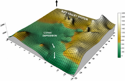
Figure 2 The Congo River Basin Elevation System. The highest
station elevation is located in the Tanzanian region while the lowest, at the
Atlantic Ocean (Note: this elevation grid is derived from the elevation of the
selected 145 meteorological stations falling inside the study area)
From the middle Congo (Chenal) the river divides into two. One
branch forms Malebo Pool, which is 24 mile by 27.3 miles large. This is the end
of the middle Congo. Just downstream are the first of 30 waterfalls as the
river continues to flow towards Matadi. At Matadi, the Congo's estuary begins
in a narrow channel only half a mile to a mile wide. Eventually it widens below
Boma but islands are once again a factor, dividing the river into several
forms. The Congo now flows freely into the Atlantic Ocean.
| 
