2.4. Description of the model of study
If it is true that the «cross sectional
profile», the installation of a road can have an impact on the
output of this road in urban environment, this impact should be able to be
checked or to be highlighted by the construction of a model which should make
it possible to confront this road with its output according to its category and
of the hours when the frequentation is maximum there.
The model adopted for the checking of the basic assumption of
the present report will thus have to take into account:
2.4.1. The
legibility and functionality of the plan of the city
The first of these requirements should allow an evaluation of
thefunctionality and legibility of the plan of the city and this through data
on the quantity and quality of the roadway network of the town of
Yaoundé.
Consequently, this criterion emphasizes the importance of the
structuring of space by suitable transportation routes which thus make it
possible to make readable the plan of the city just as it allow a better
functionality.
2.4.2. Requirements
of temporal delimitation: rush hours.
This criterion is relating to the period of collection of the
data: the data obtained should make it possible to know the capacities of
traffic at the hours of maximum frequentation.
Thus in order to be regarded as representative, a good
counting will have:
· To move away from the edges (January, December) and to
move away from the tops (July-August)
· The months representative of the year are the months
of: February, April, October,
· The weeks most representative of the month are the two
weeks of the medium
· The days representative of the week are: Thursday -
Friday - Saturday or Sunday - Monday - Tuesday
· The hours representative of the day are 7:00 - 10h or
16:00 - 19h what corresponds to the rush hours.
2.4.3. The
functioning of the transport system
This criterion is relating to urban mobility in the city
because it should enable us to evaluate mobility in the city object of the
study.
The models of simulation of traffic are important tools of
which the use is not limited simply to the planning of the transport
infrastructures. Daily, they can also be used for the regulation of the traffic
by testing the effects of technological innovations such as the Intelligent
Transport systems. They can finally be more generally used for the city
planning in general and the localization of the services and the urban
activities.
Thus, are studied there major elements for the urban
mobility such the offer of transport, the demand for transport, the traffic
motivations, the existing means of transport and reasons justifying their
choice during a displacement and finally the various zones between which
accomplishes transport in the zone of study. The delimitation of the zones of
transport constituting the key factor of this criterion, we renewed the model
made up at the time of the investigations carried out at the time the
production of the Urban Plan of Displacement of the town of Yaoundé.
This model of displacements in Yaoundé aimed at the
simulation of the traffic on the roads and the railroad in the city in order to
test scenarios of installation of the offer of infrastructures to check that
they would answer well the present needs (2010, date of realization of the
document) and futures of urban mobility. For this simulation, the Consultant
had actually built two models.
· The first is a static model, (traditional tool of
modeling based on a step at several stages which makes it possible to estimate
the various types of traffics on the whole of the network of roadway system and
of the rail network) which simulates the transport demand during the rush hour
on the whole of the network of the city and makes it possible to estimate the
various types of traffics on the whole of the network of roadway system
(mainly); It thus proves to be an extremely powerful tool to appreciate the
impact of specific installations on the general flow of the traffic.
· The second is a dynamic model of micro-simulation the
purpose of which is to optimize the time of crossing of the crossroads and the
geometry of the intersections which are often at the base of congestions. This
optimization, which is made by a simulation of traffic on precise sections is
obtained graces to the results (in flow of vehicles) of the static model.
The figure below illustrates the sequence of the various
models.

Figure 3: Sequence of the
two models at the time of the study
Source: PDU
The two models were gauged over the year under review (2010)
and were then used to simulate the situations by 2030.
Thus, the zone of study defined during the courses of this
investigation was consisted of the distribution in districts defined by the GIS
of the YCC. This distribution includes 87 internal zones and 9 external zones
(related to the penetrating roads). In order to better represent the traffic in
the downtown area, the Consultant moreover divided the zone of the
administrative and commercial center into three zones.
The table hereafter gives the names of the zones finally
retained for the study, while the chart it shows the extent of the zone.
Table1: listing of the
districts constituting the zone of study
|
AHALA
|
MBALLA 1
|
NGOUSSO 1
|
RN1 Nord
|
|
AWAE 1
|
MBALLA 2
|
NGOUSSO 2
|
RD46 NE
|
|
AWAE 2
|
MBALLA 3
|
NKOLBISSON
|
RN10 Est
|
|
BASTOS
|
MBALLA 4
|
NKOL-EBOGO
|
RD11 SE
|
|
BITENG
|
MBALLA 5
|
NKOL-MESSENG
|
RN2 Sud
|
|
BIYEM-ASSI
|
MBANKOLO
|
NKOL-NDONGO 1
|
RN3 SS
|
|
BRIQUETERIE
|
MELEN
|
NKOL-NDONGO 2
|
Route Kribi
|
|
CITE-VERTE
|
MENDONG 1
|
NKOM-KANA
|
Route Douala
|
|
EFOULAN
|
MENDONG 2
|
NLONGKAK 1
|
6751
|
|
EKOUDOU
|
MESSA CARRIERE 1
|
NLONGKAK 2
|
|
|
EKOUMDOUM
|
MESSA CARRIERE 2
|
NLONGKAK 3
|
|
|
EKOUNOU 1
|
MESSAME-NDONGO
|
NLONGKAK 4
|
|
|
EKOUNOU 2
|
MFANDENA 1
|
NSAM
|
|
|
ELIG-EDZOA
|
MFANDENA 2
|
NSIMEYONG 1
|
|
|
ELIG-ESSONO
|
MIMBOMAN 3
|
NSIMEYONG 2
|
|
|
EMANA
|
MIMBOMAN 1
|
OBILI
|
|
|
ESSOS
|
NKOMO
|
OBOBOGO 1
|
|
|
ETAM-BAFIA
|
MOKOLO
|
ODZA
|
|
|
ETETAK 1
|
MVAN
|
OLINGA
|
|
|
ETETAK 2
|
MVOG EBANDA
|
OYOM-ABANG
|
|
|
ETOA-MEKI 1
|
MVOG-ADA
|
SIMBOCK
|
|
|
ETOA-MEKI 2
|
MVOG-BETSI 1
|
TSINGA 1
|
|
|
ETOUDI
|
MVOG-BETSI 2
|
TSINGA 2
|
|
|
ETOUG-EBE
|
MVOG-MBI
|
CENTRE ADMINISTRATIF 1
|
|
|
GRAND MESSA
|
MVOLYE
|
CENTRE ADMINISTRATIF 2
|
|
|
KODENGUI 1
|
NDAMVOUT 1
|
CENTRE ADMINISTTRATIF 3
|
|
|
KODENGUI 2
|
NDAMVOUT 2
|
CENTRE COMMERCIAL 1
|
|
|
KODENGUI 3
|
NGOA-EKELLE 1
|
CENTRE COMMERCIAL 2
|
|
|
MADAGASCAR
|
NGOA-EKELLE 2
|
CENTRE COMMERCIAL 3
|
|
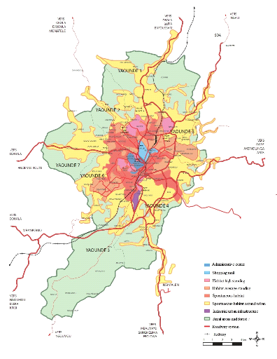
Figure 4: Modeling of the
zone of study
Source: Communauté Urbaine de
Yaoundé: Yaoundé 2020, Plan Directeur d'Urbanisme,
AUGEAINTERNATIONAL-IRIS CONSEIL-ARCAUPLAN, 2008
| 

