3.5 Calculation of the water requirements in each plot
3.5.1 System requirements
The water requirements of the plots which were been irrigated
was calculated by taking into consideration the type of irrigation system
concerned as well as the size of the plot and the number of sprinklers on the
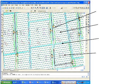
plot. AUTOCAD 2004 software was used to develop the irrigation map of each plot
and the number of sprinklers calculated. Figure 3.5 shows an irrigation map
developed with AUTOCAD 2004 software and served as the ground base for
calculating the number of sprinklers on a given plot. The number of sprinklers
was then entered into the database and the total flow rate calculated
automatically by taking the product of the flow rate, the number of sprinklers
on the plot and the efficiency of the system involved. Through queries on the
database, the total flow rate required for all the plots in production could be
calculated.
Plot valve
Sprinkler head
N02=Production
plot ID
SF6=Irrigation
plot ID
Figure 3.9: Irrigation map for a production plot
developed with AUTOCAD 2004
Through queries on the database, the system requirements of
the various plots were been calculated and the results of these printed up in
reports or used to create other tables which can be viewed from the forms
created. Figure 3.10 shows the environment for the creation of such queries
using Microsoft Access 2003 software.
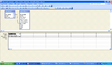
Figure 3.10: Query created in MS access to obtain the
water requirements of the system The SQL query created to obtain these
values is as follows:
UPDATE arroseur INNER JOIN parcelle_irriguée ON
arroseur.arr_model = parcelle_irriguée.arr_model SET
parcelle_irriguée.Débit_Nominal = [parcelle_irriguée].
[nbre_arroseur]*[arroseur]. [débit]
3.5.2 Crop water requirements
Crop water requirements were calculated using the water balance
equation
S(j+1)-S(j)= (Peff(j)+I(j))-(ETc(j)-D(j)) (3.1)
S(j+1)-S(j): Variation of available water content
Peff(j) : Effective rainfall
I(j) : Irrigation depth
ETc(j) : Daily crop evapotranspiration
D(j) : Drainage losses
Variation in available water content was computed in the database
by taking into consideration the water content of the previous day and that of
the following day.
Effective rainfall was computed using equations 2.4 and 2.5 by
entering these equations into an excel spreadsheet together with other
meteorological data for the different weather station involved. Rainfall after
the soil has attained its field capacity and those less than 5 mm/day are being
considered non significant to the water balance. These were considered as being
lost as runoff or by drainage.
ETc(j) was calculated as a product of the crop coefficient
Kc and the reference evapotranspiration ETp.
ETp values are being entered in the climatic data table in the
database as obtained from the records from the various meteorological stations.
Corresponding Kc values for the various plots were been used in the database
for the different number of days after planting in the plots. The Kc
values used in this work are those proposed by Allen et al., 1998.
Thus, for each plot ETc is given by equation 2.7.
Irrigation depth was calculated with respect to the system in
place; for microjet sprinkler systems, a factor of 0.9 is used while for
undertree systems, a factor of 0.85 is applied and 0.8 for big gun system to
take into consideration the efficiency of each system. Thus, the irrigation
depth is the product of the quantity of water applied and the correction
factor.
On each given date, depending on the events of the previous
day (rainfall and evapotranspiration) the quantity of water to be applied was
computed for each plot.
Using 20 year climatic data, a probability test for the risk
of non satisfaction of crop water requirements was calculated by taking the
mean of these requirements within this period for each month. Appendix I shows
the procedure used in the calculation of the water requirement as entered in MS
excel.
| 

