Hydrological modeling of the Congo River basin: Asoil-water balance approach( Télécharger le fichier original )par Bahati Chishugi Josue University of Botswana - Masters of Sciences (M.Sc.) 2008 |

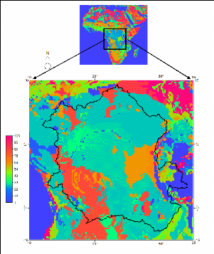
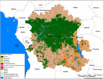
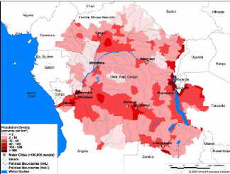
2.5 SoilsGenerally, there are two types of soils in the study area: those of the equatorial areas and those of the drier savanna (grassland) regions. The equatorial soils occur in the warm, humid lowlands of the central basin, which receive abundant rainfall throughout the year and are covered mainly with thick forests. This soil is almost fixed in place because of the lack of erosive forces in the forests. In the shore areas, however, swamp vegetation has built up a remarkably thick soil that is constantly nourished by humus, the organic material resulting from the decomposition of plant or animal matter. Although in the savanna regions the soils are constantly endangered by erosion, the river valleys contain rich and fertile alluvial soils. Special note should be made of the highlands of eastern Congo in the Great Lakes region, which are partly covered with volcanic lava that has been transformed into exceptionally rich soil. An agronomic soil map at 10X10 spatial resolutions (Figure 1 1) is available at FAO-UNESCO database (1984). This map can be resampled and reclassified according to the objectives of the research. In Hydrological modelling, a textural Soil map is required to derive soil retention properties such as field capacity, wilting point, available water content, etc. For the southern Africa, Alemaw and Chaoka (2003) demonstrate the usefulness of the agronomic soil data in deriving soil texture classes for hydrological modelling. 2.6 Land cover/use and Population densityThe land cover pattern of the Congo basin is viewed in Figure9 and summarised in Table 3. Mostly, the basin is coverd by green and dense forest. Dryer regions occupy less then 0.2 % of the basin. Figure 10 below shows the population density distribution over the basin.
Figure 8 Congo Basin Agronomic Soils Map. The polygon
limit the Congo watershed
Figure 9 Vegetation and Land cover and uses over the Congo River Watershed (after World river resources, 2003)
Figure 10 Population density distribution over the Congo River Watershed: Basin area 3,730,881 sq.Km, Average Population Density (people per sq.km): 15, Number of large cities (100,000 people). 2.7 GeologyThe Geology of the Democratic Republic of Congo is characterized by two large structural units separated by discordance and/or a significant gap: The Formations of covers (Phanerozoic), not metamorphosed, generally fossiliferous, and of age ranging between the Upper carboniferous and the Holocene; and the Basement terrains (Precambrian shield): Highly metamorphosed + shielded contouring continuously the basin. 2.7.1 Basement formation The Basement terrains are subdivided in "tectostratigraphic" units:
2.7.2 Surface formations The surface formations are grouped into four zones as follows:
The formations of each one of these 4 great zones are covered indifferently by recent formations, the ochre series of sands and the series of the polymorphic sandstones. |
|